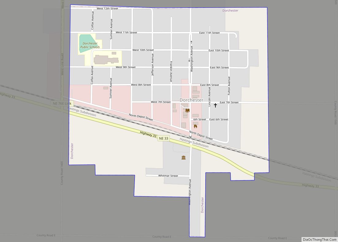
Map of Du Bois village, Nebraska
Du Bois(/du.ˈbɔɪz/ doo-BOYZ) is a village in the southeast corner of Pawnee County, Nebraska, United States. The population was 124 at the 2020 census. Du Bois village overview: Name: Du Bois village LSAD Code: 47 LSAD Description: village (suffix) State: Nebraska County: Pawnee County Elevation: 1,050 ft (320 m) Total Area: 0.45 sq mi (1.18 km²) Land Area: 0.45 sq mi (1.18 km²) ... Read more
Map of Du Bois village, Nebraska
Map of Douglas village, Nebraska
Douglas is a village in southwest Otoe County, Nebraska, United States. The population was 166 at the 2020 census. Douglas village overview: Name: Douglas village LSAD Code: 47 LSAD Description: village (suffix) State: Nebraska County: Otoe County Elevation: 1,250 ft (380 m) Total Area: 0.22 sq mi (0.57 km²) Land Area: 0.22 sq mi (0.57 km²) Water Area: 0.00 sq mi (0.00 km²) Total Population: 166 ... Read more
Map of Douglas village, Nebraska
Map of Elsie village, Nebraska
Elsie is a village in Perkins County, Nebraska, United States. The population was 106 at the 2010 census. Elsie village overview: Name: Elsie village LSAD Code: 47 LSAD Description: village (suffix) State: Nebraska County: Perkins County Elevation: 3,389 ft (1,033 m) Total Area: 0.17 sq mi (0.45 km²) Land Area: 0.17 sq mi (0.45 km²) Water Area: 0.00 sq mi (0.00 km²) Total Population: 102 Population ... Read more
Map of Elsie village, Nebraska
Map of Elmwood village, Nebraska
Elmwood is a village in southeast Cass County, Nebraska, United States. The population was 654 at the 2020 census. Elmwood village overview: Name: Elmwood village LSAD Code: 47 LSAD Description: village (suffix) State: Nebraska County: Cass County Elevation: 1,289 ft (393 m) Total Area: 0.38 sq mi (0.97 km²) Land Area: 0.38 sq mi (0.97 km²) Water Area: 0.00 sq mi (0.00 km²) Total Population: 654 ... Read more
Map of Elmwood village, Nebraska
Map of Elm Creek village, Nebraska
Elm Creek is a village in Buffalo County, Nebraska, United States. It is part of the Kearney, Nebraska Micropolitan Statistical Area. The population was 979 at the 2020 census. Elm Creek village overview: Name: Elm Creek village LSAD Code: 47 LSAD Description: village (suffix) State: Nebraska County: Buffalo County Elevation: 2,266 ft (691 m) Total Area: 0.69 sq mi ... Read more
Map of Elm Creek village, Nebraska
Map of Elk Creek village, Nebraska
Elk Creek is a village in Johnson County, Nebraska, United States. The population was 67 at the 2020 census. Elk Creek village overview: Name: Elk Creek village LSAD Code: 47 LSAD Description: village (suffix) State: Nebraska County: Johnson County Elevation: 1,102 ft (336 m) Total Area: 0.13 sq mi (0.34 km²) Land Area: 0.13 sq mi (0.34 km²) Water Area: 0.00 sq mi (0.00 km²) Total ... Read more
Map of Elk Creek village, Nebraska
Map of Elgin city, Nebraska
Elgin is a city in Antelope County, Nebraska, United States. The population was 661 at the 2010 census. Elgin city overview: Name: Elgin city LSAD Code: 25 LSAD Description: city (suffix) State: Nebraska County: Antelope County Elevation: 1,926 ft (587 m) Total Area: 0.73 sq mi (1.89 km²) Land Area: 0.73 sq mi (1.89 km²) Water Area: 0.00 sq mi (0.00 km²) Total Population: 717 Population ... Read more
Map of Elgin city, Nebraska
Map of Elba village, Nebraska
Elba is a village in Howard County, Nebraska, United States. The population was 215 at the 2010 census. It is part of the Grand Island, Nebraska Micropolitan Statistical Area. Elba village overview: Name: Elba village LSAD Code: 47 LSAD Description: village (suffix) State: Nebraska County: Howard County Elevation: 1,860 ft (567 m) Total Area: 0.37 sq mi (0.95 km²) Land ... Read more
Map of Elba village, Nebraska
Map of Edison village, Nebraska
Edison is a village in Furnas County, Nebraska, United States. The population was 133 at the 2010 census. Edison village overview: Name: Edison village LSAD Code: 47 LSAD Description: village (suffix) State: Nebraska County: Furnas County Elevation: 2,113 ft (644 m) Total Area: 0.38 sq mi (0.97 km²) Land Area: 0.38 sq mi (0.97 km²) Water Area: 0.00 sq mi (0.00 km²) Total Population: 111 Population ... Read more
Map of Edison village, Nebraska
Map of Edgar city, Nebraska
Edgar is a city in Clay County, Nebraska, United States. The population was 498 at the 2010 census. It is part of the Hastings, Nebraska Micropolitan Statistical Area. Edgar city overview: Name: Edgar city LSAD Code: 25 LSAD Description: city (suffix) State: Nebraska County: Clay County Elevation: 1,722 ft (525 m) Total Area: 0.79 sq mi (2.05 km²) Land Area: ... Read more
Map of Edgar city, Nebraska
Map of Elyria village, Nebraska
Elyria is a village in Valley County, Nebraska, United States. The population was 51 at the 2010 census. Elyria village overview: Name: Elyria village LSAD Code: 47 LSAD Description: village (suffix) State: Nebraska County: Valley County Elevation: 2,103 ft (641 m) Total Area: 0.27 sq mi (0.69 km²) Land Area: 0.27 sq mi (0.69 km²) Water Area: 0.00 sq mi (0.00 km²) Total Population: 50 Population ... Read more
Map of Elyria village, Nebraska
Map of Elwood village, Nebraska
Elwood is a village and the county seat of Gosper County, Nebraska, United States. It is part of the Lexington, Nebraska Micropolitan Statistical Area. The population was 707 at the 2010 census. Elwood village overview: Name: Elwood village LSAD Code: 47 LSAD Description: village (suffix) State: Nebraska County: Gosper County Elevation: 2,667 ft (813 m) Total Area: ... Read more
Map of Elwood village, Nebraska