Map of Omaha city, Nebraska

Map of Omaha city, Nebraska

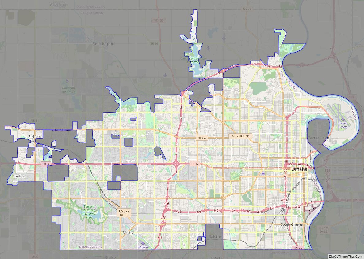
Omaha (/ˈoʊməhɑː/ OH-mə-hah) is the largest city in the U.S. state of Nebraska and the county seat of Douglas County. Omaha is in the Midwestern United States on the Missouri River, about 10 mi (15 km) north of the mouth of the Platte River. The nation’s 39th-largest city, Omaha’s 2020 census population was 486,051. Omaha is the … Read more

Map of Lincoln city, Nebraska

Map of Lincoln city, Nebraska

Lincoln is the capital city of the U.S. state of Nebraska and the county seat of Lancaster County. The city covers 100.4 square miles (260.035 km) with a population of 292,657 in 2021. It is Nebraska’s second-most populous city and the 73rd-largest in the United States. Lincoln is the economic and cultural anchor of a substantially … Read more

Map of Grand Island city

Map of Grand Island city

Grand Island is a city in and the county seat of Hall County, Nebraska, United States. The population was 53,131 at the 2020 census. Grand Island is the principal city of the Grand Island metropolitan area, which consists of Hall, Merrick, Howard and Hamilton counties. The Grand Island metropolitan area has an official population of … Read more

Map of Bellevue city, Nebraska

Map of Bellevue city, Nebraska

Bellevue (French for “beautiful view”; previously named Belleview) is a suburban city in Sarpy County, Nebraska, United States. It is part of the Omaha–Council Bluffs metropolitan area, and had a population of 64,176 as of the 2020 Census, making it the third-largest city in Nebraska, behind Omaha and Lincoln, and the second largest city in … Read more

Map of Kearney city, Nebraska

Map of Kearney city, Nebraska

Kearney (/ˈkɑːrni/ KARR-nee) is the county seat of Buffalo County, Nebraska, United States. The population was 33,790 in the 2020 census. It is home to the University of Nebraska at Kearney. The westward push of the railroad as the Civil War ended gave new birth to the community. Kearney city overview: Name: Kearney city LSAD … Read more

Map of Alda village

Map of Alda village

Alda is a village in Hall County, Nebraska, United States. The population was 642 at the 2010 census. It is part of the Grand Island, Nebraska Micropolitan Statistical Area. Alda village overview: Name: Alda village LSAD Code: 47 LSAD Description: village (suffix) State: Nebraska County: Hall County Elevation: 1,916 ft (584 m) Total Area: 0.56 sq mi (1.46 km²) Land … Read more

Map of Albion city, Nebraska

Map of Albion city, Nebraska

Albion is a city in and the county seat of Boone County, Nebraska, United States. The population was 1,650 at the 2010 census. Albion city overview: Name: Albion city LSAD Code: 25 LSAD Description: city (suffix) State: Nebraska County: Boone County Elevation: 1,772 ft (540 m) Total Area: 1.04 sq mi (2.70 km²) Land Area: 1.04 sq mi (2.70 km²) Water Area: 0.00 sq mi … Read more

Map of Ainsworth city, Nebraska

Map of Ainsworth city, Nebraska

Ainsworth is a city and county seat of Brown County, Nebraska, United States. The population was 1,728 at the 2010 census. Ainsworth city overview: Name: Ainsworth city LSAD Code: 25 LSAD Description: city (suffix) State: Nebraska County: Brown County Elevation: 2,520 ft (768 m) Total Area: 1.00 sq mi (2.60 km²) Land Area: 1.00 sq mi (2.60 km²) Water Area: 0.00 sq mi (0.00 km²) Total … Read more

Map of Adams village, Nebraska

Map of Adams village, Nebraska

Adams is a village in Gage County, Nebraska, United States. The population was 604 at the 2020 census. Adams village overview: Name: Adams village LSAD Code: 47 LSAD Description: village (suffix) State: Nebraska County: Gage County Elevation: 1,247 ft (380 m) Total Area: 0.59 sq mi (1.54 km²) Land Area: 0.59 sq mi (1.54 km²) Water Area: 0.00 sq mi (0.00 km²) Total Population: 604 Population … Read more

Map of Abie village

Map of Abie village

Abie is a village in Butler County, Nebraska, United States. The population was 69 at the 2010 census. Abie village overview: Name: Abie village LSAD Code: 47 LSAD Description: village (suffix) State: Nebraska County: Butler County Elevation: 1,463 ft (446 m) Total Area: 0.09 sq mi (0.24 km²) Land Area: 0.09 sq mi (0.24 km²) Water Area: 0.00 sq mi (0.00 km²) Total Population: 65 Population … Read more

Map of Alliance city, Nebraska

Map of Alliance city, Nebraska

Alliance is a city and the county seat of Box Butte County, in the western part of the state of Nebraska, in the Great Plains region of the United States. Its population was 8,151 at the 2020 census. Alliance is the home to Carhenge, a replica of Stonehenge constructed with automobiles, which is located north … Read more

Map of Allen village, Nebraska

Map of Allen village, Nebraska

Allen is a village in Dixon County, Nebraska, United States. Located south of US Hwy 20 on NE Hwy 9 between Martinsburg, NE and Wakefield, NE. It is part of the Sioux City, IA–NE–SD Metropolitan Statistical Area. The population was 377 at the 2010 census. Allen village overview: Name: Allen village LSAD Code: 47 LSAD … Read more