Map of Hooper city, Nebraska
Hooper is a city in Dodge County, Nebraska, United States. The population was 830 at the 2010 census. Hooper city overview: Name: Hooper city LSAD Code: 25 LSAD Description: city (suffix) State: Nebraska County: Dodge County Elevation: 1,230 ft (375 m) Total Area: 0.69 sq mi (1.79 km²) Land Area: 0.68 sq mi (1.76 km²) Water Area: 0.01 sq mi (0.03 km²) Total Population: 857 Population ... Read more
Map of Hooper city, Nebraska
Map of Homer village, Nebraska
Homer is a village in Dakota County, Nebraska, United States. It is part of the Sioux City, IA–NE–SD Metropolitan Statistical Area. The population was 549 at the 2010 census. Homer village overview: Name: Homer village LSAD Code: 47 LSAD Description: village (suffix) State: Nebraska County: Dakota County Elevation: 1,109 ft (338 m) Total Area: 0.37 sq mi (0.96 km²) Land ... Read more
Map of Homer village, Nebraska
Map of Holstein village, Nebraska
Holstein is a village in Adams County, Nebraska, United States. The population was 188 at the 2020 census. It is part of the Hastings, Nebraska Micropolitan Statistical Area. Holstein village overview: Name: Holstein village LSAD Code: 47 LSAD Description: village (suffix) State: Nebraska County: Adams County Elevation: 2,008 ft (612 m) Total Area: 0.25 sq mi (0.66 km²) Land Area: ... Read more
Map of Holstein village, Nebraska
Map of Holmesville CDP, Nebraska
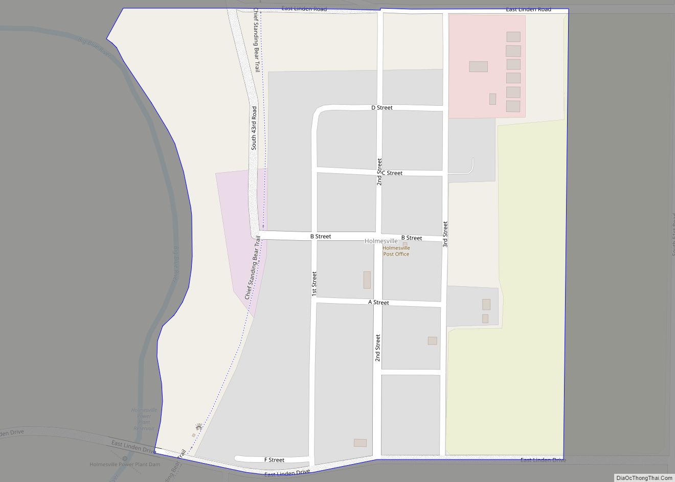
Holmesville is a census-designated place (CDP) in Gage County, Nebraska, United States. As of the 2010 census it had a population of 51. Holmesville CDP overview: Name: Holmesville CDP LSAD Code: 57 LSAD Description: CDP (suffix) State: Nebraska County: Gage County Elevation: 1,263 ft (385 m) Total Area: 0.23 sq mi (0.58 km²) Land Area: 0.22 sq mi (0.58 km²) Water Area: 0.00 sq mi ... Read more
Map of Holmesville CDP, Nebraska
Map of Holdrege city
Holdrege is a city in Phelps County, Nebraska, United States. The population was 5,495 at the 2010 census. It is the county seat of Phelps County. The Nebraska Prairie Museum is located in Holdrege. Holdrege city overview: Name: Holdrege city LSAD Code: 25 LSAD Description: city (suffix) State: Nebraska County: Phelps County Elevation: 2,329 ft (710 m) ... Read more
Map of Holdrege city
Map of Holbrook village, Nebraska
Holbrook is a village in Furnas County, Nebraska, United States. The population was 207 at the 2010 census. Holbrook village overview: Name: Holbrook village LSAD Code: 47 LSAD Description: village (suffix) State: Nebraska County: Furnas County Elevation: 2,211 ft (674 m) Total Area: 0.16 sq mi (0.42 km²) Land Area: 0.16 sq mi (0.42 km²) Water Area: 0.00 sq mi (0.00 km²) Total Population: 201 Population ... Read more
Map of Holbrook village, Nebraska
Map of Hildreth village
Hildreth is a village in Franklin County, Nebraska, United States. The population was 378 at the 2010 census. Hildreth village overview: Name: Hildreth village LSAD Code: 47 LSAD Description: village (suffix) State: Nebraska County: Franklin County Elevation: 2,175 ft (663 m) Total Area: 0.57 sq mi (1.48 km²) Land Area: 0.57 sq mi (1.48 km²) Water Area: 0.00 sq mi (0.00 km²) Total Population: 377 Population ... Read more
Map of Hildreth village
Map of Hickman city, Nebraska
Hickman is a city in Lancaster County, Nebraska, United States. It is part of the Lincoln, Nebraska Metropolitan Statistical Area. The population was 2,607 at the 2020 census. Hickman city overview: Name: Hickman city LSAD Code: 25 LSAD Description: city (suffix) State: Nebraska County: Lancaster County Elevation: 1,270 ft (390 m) Total Area: 0.89 sq mi (2.31 km²) Land Area: ... Read more
Map of Hickman city, Nebraska
Map of Humphrey city, Nebraska
Humphrey is a city in Platte County, Nebraska, United States. The population was 760 at the 2010 census. Humphrey city overview: Name: Humphrey city LSAD Code: 25 LSAD Description: city (suffix) State: Nebraska County: Platte County Elevation: 1,670 ft (509 m) Total Area: 0.50 sq mi (1.29 km²) Land Area: 0.49 sq mi (1.28 km²) Water Area: 0.00 sq mi (0.01 km²) Total Population: 857 Population ... Read more
Map of Humphrey city, Nebraska
Map of Humboldt city, Nebraska
Humboldt is a city in Richardson County, Nebraska, United States. The population was 800 at the 2020 census. Humboldt city overview: Name: Humboldt city LSAD Code: 25 LSAD Description: city (suffix) State: Nebraska County: Richardson County Elevation: 1,020 ft (310 m) Total Area: 1.33 sq mi (3.46 km²) Land Area: 1.33 sq mi (3.46 km²) Water Area: 0.00 sq mi (0.00 km²) Total Population: 800 Population ... Read more
Map of Humboldt city, Nebraska
Map of Hubbell village, Nebraska
Hubbell is a village in Thayer County, Nebraska, United States. The population was 63 at the 2020 census. Hubbell village overview: Name: Hubbell village LSAD Code: 47 LSAD Description: village (suffix) State: Nebraska County: Thayer County Elevation: 1,470 ft (448 m) Total Area: 0.31 sq mi (0.81 km²) Land Area: 0.31 sq mi (0.81 km²) Water Area: 0.00 sq mi (0.00 km²) Total Population: 63 Population ... Read more
Map of Hubbell village, Nebraska
Map of Hubbard village, Nebraska
Hubbard is a village in Dakota County, Nebraska, United States. It is part of the Sioux City, IA–NE–SD Metropolitan Statistical Area. The population was 236 at the 2010 census. Hubbard village overview: Name: Hubbard village LSAD Code: 47 LSAD Description: village (suffix) State: Nebraska County: Dakota County Elevation: 1,158 ft (353 m) Total Area: 0.17 sq mi (0.43 km²) Land ... Read more
Map of Hubbard village, Nebraska