Map of Tecumseh city, Nebraska
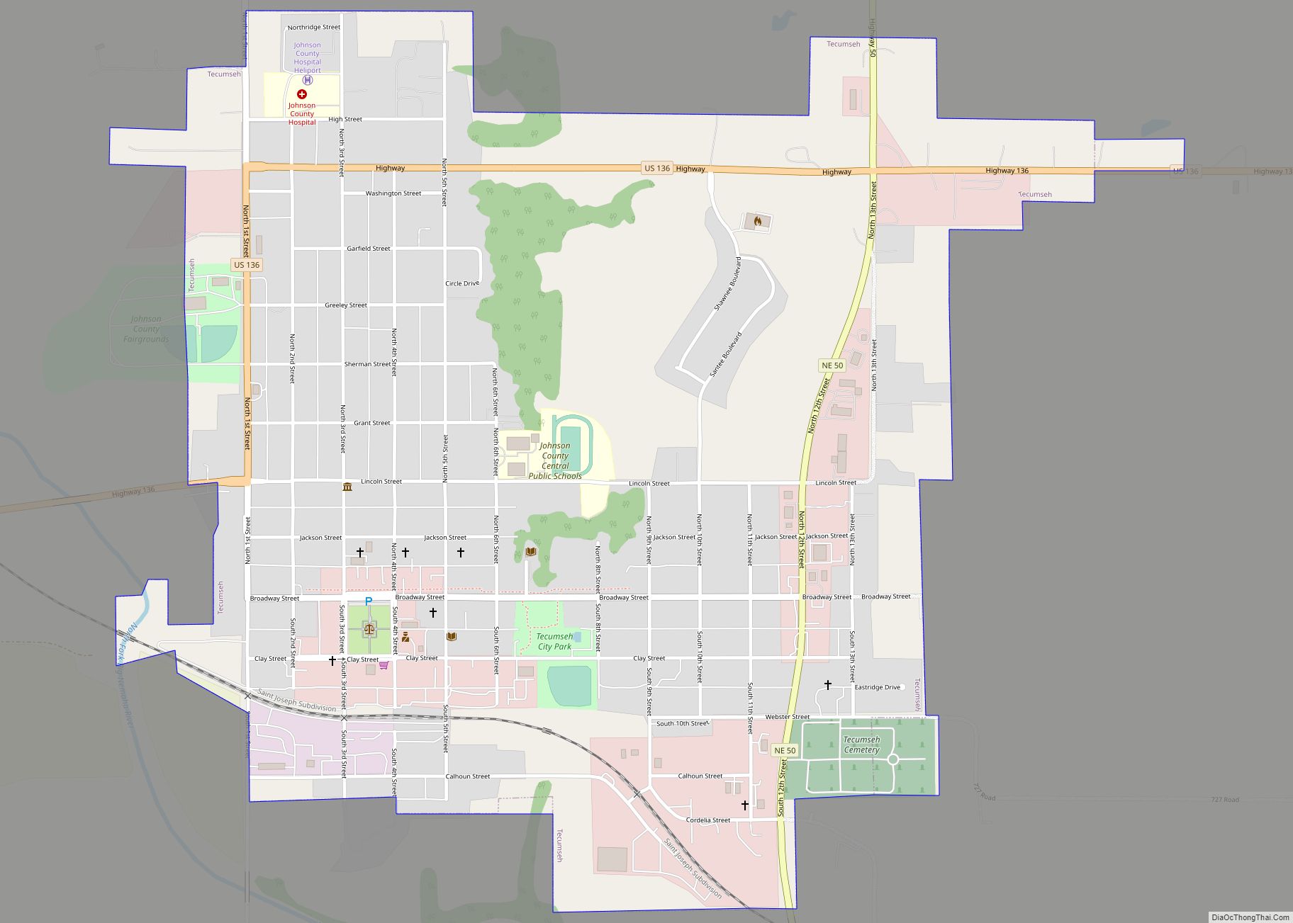
Tecumseh is a city in and the county seat of Johnson County, Nebraska, United States. The population was 1,677 at the 2010 census. Tecumseh city overview: Name: Tecumseh city LSAD Code: 25 LSAD Description: city (suffix) State: Nebraska County: Johnson County Elevation: 1,129 ft (344 m) Total Area: 1.51 sq mi (3.91 km²) Land Area: 1.51 sq mi (3.91 km²) Water Area: 0.00 sq mi ... Read more
Map of Tecumseh city, Nebraska
Map of Taylor village, Nebraska
Taylor is a village in, and the county seat of, Loup County, Nebraska, United States. The population was 190 at the 2010 census. Taylor village overview: Name: Taylor village LSAD Code: 47 LSAD Description: village (suffix) State: Nebraska County: Loup County Elevation: 2,267 ft (691 m) Total Area: 0.26 sq mi (0.68 km²) Land Area: 0.26 sq mi (0.68 km²) Water Area: 0.00 sq mi ... Read more
Map of Taylor village, Nebraska
Map of Tarnov village
Tarnov is a village in Platte County, Nebraska, United States. The population was 46 at the 2010 census. Tarnov village overview: Name: Tarnov village LSAD Code: 47 LSAD Description: village (suffix) State: Nebraska County: Platte County Elevation: 1,650 ft (503 m) Total Area: 0.03 sq mi (0.08 km²) Land Area: 0.03 sq mi (0.08 km²) Water Area: 0.00 sq mi (0.00 km²) Total Population: 52 Population ... Read more
Map of Tarnov village
Map of Tamora CDP
Tamora (/təˈmɔːrə/ tə-MOR-ə) is an unincorporated community and census-designated place in Seward County, in the southeastern part of the state of Nebraska in the Midwestern United States. The town presently consists of a large grain elevator complex and a small residential district, with a population of about 70. Tamora CDP overview: Name: Tamora CDP LSAD ... Read more
Map of Tamora CDP
Map of Trenton village, Nebraska
Trenton is a village in Hitchcock County, Nebraska, United States. The population was 516 at the 2020 census. It is the county seat of Hitchcock County. Trenton village overview: Name: Trenton village LSAD Code: 47 LSAD Description: village (suffix) State: Nebraska County: Hitchcock County Elevation: 2,674 ft (815 m) Total Area: 0.58 sq mi (1.51 km²) Land Area: 0.58 sq mi (1.51 km²) ... Read more
Map of Trenton village, Nebraska
Map of Tobias village
Tobias is a village in Saline County, Nebraska, United States. The population was 106 at the 2010 census. Tobias village overview: Name: Tobias village LSAD Code: 47 LSAD Description: village (suffix) State: Nebraska County: Saline County Elevation: 1,604 ft (489 m) Total Area: 0.26 sq mi (0.68 km²) Land Area: 0.26 sq mi (0.68 km²) Water Area: 0.00 sq mi (0.00 km²) Total Population: 114 Population ... Read more
Map of Tobias village
Map of Utica village, Nebraska
Utica is a village in Seward County, Nebraska, United States. It is part of the Lincoln, Nebraska Metropolitan Statistical Area. The population was 861 at the 2010 census. Utica village overview: Name: Utica village LSAD Code: 47 LSAD Description: village (suffix) State: Nebraska County: Seward County Elevation: 1,591 ft (485 m) Total Area: 0.46 sq mi (1.19 km²) Land Area: ... Read more
Map of Utica village, Nebraska
Map of Upland village, Nebraska
Upland is a village in Franklin County, Nebraska, United States. The population was 143 at the 2010 census. Upland village overview: Name: Upland village LSAD Code: 47 LSAD Description: village (suffix) State: Nebraska County: Franklin County Elevation: 2,162 ft (659 m) Total Area: 0.44 sq mi (1.13 km²) Land Area: 0.44 sq mi (1.13 km²) Water Area: 0.00 sq mi (0.00 km²) Total Population: 125 Population ... Read more
Map of Upland village, Nebraska
Map of Union village, Nebraska
Union is a village in southeast Cass County, Nebraska, United States. The population was 195 at the 2020 census. Union village overview: Name: Union village LSAD Code: 47 LSAD Description: village (suffix) State: Nebraska County: Cass County Elevation: 1,017 ft (310 m) Total Area: 0.21 sq mi (0.54 km²) Land Area: 0.21 sq mi (0.54 km²) Water Area: 0.00 sq mi (0.00 km²) Total Population: 195 ... Read more
Map of Union village, Nebraska
Map of Unadilla village, Nebraska
Unadilla is a village in Otoe County, Nebraska, United States. The population was 296 at the 2020 census. Unadilla village overview: Name: Unadilla village LSAD Code: 47 LSAD Description: village (suffix) State: Nebraska County: Otoe County Elevation: 1,106 ft (337 m) Total Area: 0.33 sq mi (0.84 km²) Land Area: 0.33 sq mi (0.84 km²) Water Area: 0.00 sq mi (0.00 km²) Total Population: 296 Population ... Read more
Map of Unadilla village, Nebraska
Map of Ulysses village, Nebraska
Ulysses is a village in Butler County, Nebraska, United States. The population was 171 at the 2010 census. Ulysses village overview: Name: Ulysses village LSAD Code: 47 LSAD Description: village (suffix) State: Nebraska County: Butler County Elevation: 1,526 ft (465 m) Total Area: 0.22 sq mi (0.56 km²) Land Area: 0.22 sq mi (0.56 km²) Water Area: 0.00 sq mi (0.00 km²) Total Population: 196 Population ... Read more
Map of Ulysses village, Nebraska
Map of Uehling village
Uehling is a village in Dodge County, Nebraska, United States. The population was 230 at the 2010 census. Uehling village overview: Name: Uehling village LSAD Code: 47 LSAD Description: village (suffix) State: Nebraska County: Dodge County Elevation: 1,260 ft (384 m) Total Area: 0.22 sq mi (0.58 km²) Land Area: 0.22 sq mi (0.58 km²) Water Area: 0.00 sq mi (0.00 km²) Total Population: 241 Population ... Read more
Map of Uehling village