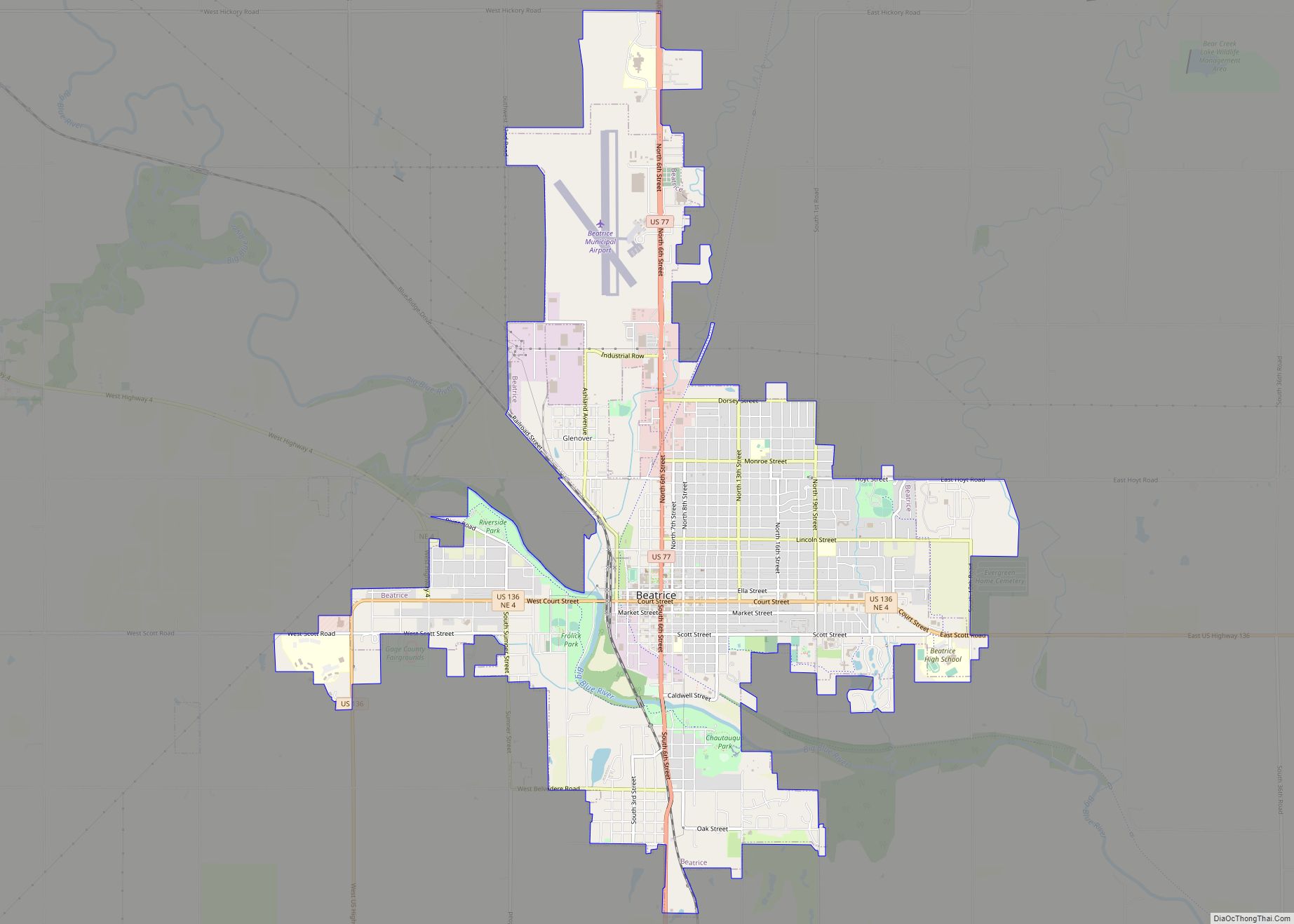
Map of Beaver Crossing village

Map of Beaver Crossing village

Beaver Crossing is a village in Seward County, Nebraska, United States. The population was 403 at the 2010 census. Beaver Crossing village overview: Name: Beaver Crossing village LSAD Code: 47 LSAD Description: village (suffix) State: Nebraska County: Seward County Elevation: 1,467 ft (447 m) Total Area: 0.66 sq mi (1.71 km²) Land Area: 0.66 sq mi (1.70 km²) Water Area: 0.01 sq mi (0.02 km²) Total … Read more

Map of Beaver City city

Map of Beaver City

Beaver City is a city in Furnas County, on the southern border of Nebraska, United States. The population was 609 at the 2010 census. It is the county seat of Furnas County. Beaver City overview: Name: Beaver City LSAD Code: 25 LSAD Description: city (suffix) State: Nebraska County: Furnas County Elevation: 2,178 ft (664 m) Total Area: … Read more

Map of Berea CDP, Nebraska

Map of Berea CDP, Nebraska

Berea is an unincorporated community and census-designated place in Box Butte County, in the northwestern part of the state of Nebraska in the Midwestern United States. It had a population of 41 at the 2010 census. Berea CDP overview: Name: Berea CDP LSAD Code: 57 LSAD Description: CDP (suffix) State: Nebraska County: Box Butte County … Read more

Map of Bennington city, Nebraska

Map of Bennington city, Nebraska

Bennington is a city in Douglas County, Nebraska, United States. The population was 2,026 at the 2020 U.S. Census. Bennington city overview: Name: Bennington city LSAD Code: 25 LSAD Description: city (suffix) State: Nebraska County: Douglas County Elevation: 1,148 ft (350 m) Total Area: 0.91 sq mi (2.35 km²) Land Area: 0.89 sq mi (2.32 km²) Water Area: 0.01 sq mi (0.03 km²) Total Population: 2,026 … Read more

Map of Bennet village

Map of Bennet village

Bennet is a village in Lancaster County, Nebraska, United States. It is part of the Lincoln, Nebraska Metropolitan Statistical Area. The population was 1,082 at the 2020 census. Bennet village overview: Name: Bennet village LSAD Code: 47 LSAD Description: village (suffix) State: Nebraska County: Lancaster County Elevation: 1,299 ft (396 m) Total Area: 0.52 sq mi (1.35 km²) Land Area: … Read more

Map of Benkelman city

Map of Benkelman city

Benkelman is a city in, and the county seat of, Dundy County, Nebraska, United States. As of the 2020 census, the city population was 821. Benkelman city overview: Name: Benkelman city LSAD Code: 25 LSAD Description: city (suffix) State: Nebraska County: Dundy County Elevation: 2,986 ft (910 m) Total Area: 1.20 sq mi (3.11 km²) Land Area: 1.20 sq mi (3.11 km²) Water … Read more

Map of Benedict village, Nebraska

Map of Benedict village, Nebraska

Benedict is a village in York County, Nebraska, United States. The population was 234 at the 2010 census. Benedict village overview: Name: Benedict village LSAD Code: 47 LSAD Description: village (suffix) State: Nebraska County: York County Elevation: 1,680 ft (512 m) Total Area: 0.18 sq mi (0.47 km²) Land Area: 0.18 sq mi (0.47 km²) Water Area: 0.00 sq mi (0.00 km²) Total Population: 203 Population … Read more

Map of Belvidere village, Nebraska

Map of Belvidere village, Nebraska

Belvidere is a village in Thayer County, Nebraska, United States. The population was 51 at the 2020 census. Belvidere village overview: Name: Belvidere village LSAD Code: 47 LSAD Description: village (suffix) State: Nebraska County: Thayer County Elevation: 1,496 ft (456 m) Total Area: 0.47 sq mi (1.21 km²) Land Area: 0.47 sq mi (1.21 km²) Water Area: 0.00 sq mi (0.00 km²) Total Population: 51 Population … Read more

Map of Belmar CDP

Map of Belmar CDP, Nebraska

Belmar is an unincorporated community and census-designated place in Keith County, Nebraska, United States. As of the 2010 census it had a population of 216. Belmar CDP overview: Name: Belmar CDP LSAD Code: 57 LSAD Description: CDP (suffix) State: Nebraska County: Keith County Elevation: 3,353 ft (1,022 m) Total Area: 4.58 sq mi (11.87 km²) Land Area: 4.58 sq mi (11.87 km²) Water … Read more

Map of Bellwood village, Nebraska

Map of Bellwood village, Nebraska

Bellwood is a village in Butler County, Nebraska, United States. The population was 435 at the 2010 census. Bellwood village overview: Name: Bellwood village LSAD Code: 47 LSAD Description: village (suffix) State: Nebraska County: Butler County Elevation: 1,444 ft (440 m) Total Area: 0.23 sq mi (0.61 km²) Land Area: 0.23 sq mi (0.61 km²) Water Area: 0.00 sq mi (0.00 km²) Total Population: 407 Population … Read more

Map of Belgrade village, Nebraska

Map of Belgrade village, Nebraska

Belgrade is a village in Nance County, Nebraska, United States. The population was 126 at the 2010 census. Belgrade village overview: Name: Belgrade village LSAD Code: 47 LSAD Description: village (suffix) State: Nebraska County: Nance County Elevation: 1,736 ft (529 m) Total Area: 0.19 sq mi (0.50 km²) Land Area: 0.19 sq mi (0.50 km²) Water Area: 0.00 sq mi (0.00 km²) Total Population: 103 Population … Read more

Map of Belden village, Nebraska

Map of Belden village, Nebraska

Belden is a village in Cedar County, Nebraska, United States. The population was 112 at the 2020 census. Belden village overview: Name: Belden village LSAD Code: 47 LSAD Description: village (suffix) State: Nebraska County: Cedar County Elevation: 1,558 ft (475 m) Total Area: 0.15 sq mi (0.39 km²) Land Area: 0.15 sq mi (0.39 km²) Water Area: 0.00 sq mi (0.00 km²) Total Population: 112 Population … Read more