Map of Lakeridge CDP
Lakeridge is a census-designated place (CDP) in Douglas County, Nevada, United States. The population was 371 at the 2010 census. Lakeridge CDP overview: Name: Lakeridge CDP LSAD Code: 57 LSAD Description: CDP (suffix) State: Nevada County: Douglas County Elevation: 6,400 ft (2,000 m) Total Area: 1.53 sq mi (3.97 km²) Land Area: 1.46 sq mi (3.77 km²) Water Area: 0.08 sq mi (0.20 km²) Total Population: ... Read more
Map of Lakeridge CDP
Map of Kingston CDP, Nevada
Kingston is an unincorporated town and census-designated place in Lander County, Nevada, United States. The population of the census-designated place of Kingston was 113 at the 2010 census. Kingston CDP overview: Name: Kingston CDP LSAD Code: 57 LSAD Description: CDP (suffix) State: Nevada County: Lander County Elevation: 5,962 ft (1,817 m) Total Area: 4.07 sq mi (10.54 km²) Land Area: ... Read more
Map of Kingston CDP, Nevada
Map of Kingsbury CDP, Nevada
Kingsbury is a census-designated place (CDP) in Douglas County, Nevada, United States. The population was 2,152 at the 2010 census. Kingsbury CDP overview: Name: Kingsbury CDP LSAD Code: 57 LSAD Description: CDP (suffix) State: Nevada County: Douglas County Elevation: 7,218 ft (2,200 m) Total Area: 21.81 sq mi (56.49 km²) Land Area: 21.81 sq mi (56.49 km²) Water Area: 0.00 sq mi (0.00 km²) Total Population: ... Read more
Map of Kingsbury CDP, Nevada
Map of Johnson Lane CDP
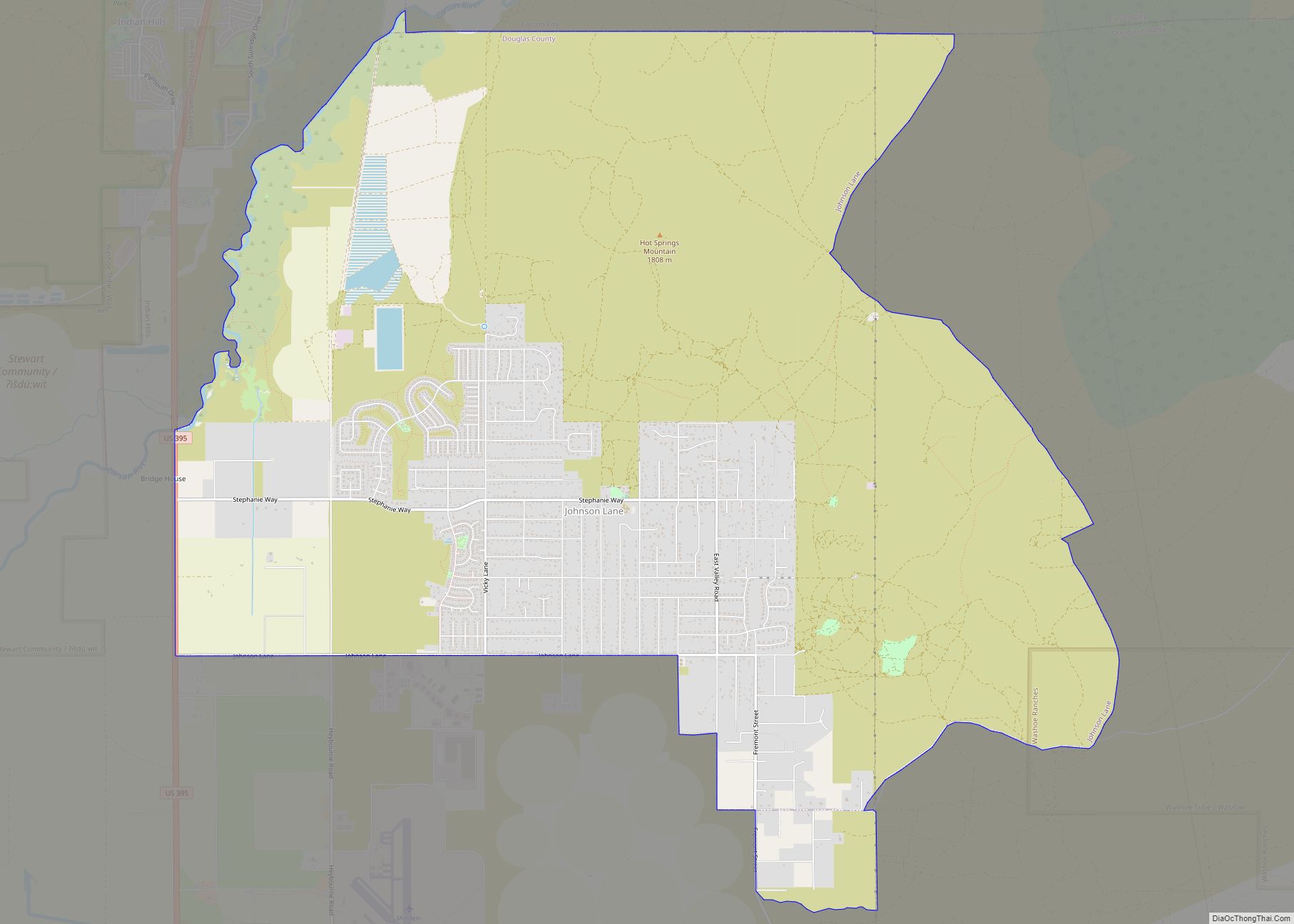
Johnson Lane is a census-designated place (CDP) in the south side of the Carson City metropolitan area in Douglas County, Nevada, United States. Its population was 6,490 at the 2010 census. Johnson Lane CDP overview: Name: Johnson Lane CDP LSAD Code: 57 LSAD Description: CDP (suffix) State: Nevada County: Douglas County Elevation: 4,820 ft (1,470 m) Total ... Read more
Map of Johnson Lane CDP
Map of Jackpot CDP
Jackpot is an unincorporated community and census-designated place (CDP) in Elko County, Nevada, United States. The population was 855 as of the 2020 census. Located less than one mile (1.6 km) from the Idaho border on US 93, Jackpot has been a popular casino gaming destination for residents of Idaho and other neighboring states since its ... Read more
Map of Jackpot CDP
Map of Indian Springs CDP, Nevada
Indian Springs is an unincorporated town and a census-designated place located on U.S. Route 95 next to Creech Air Force Base in northwestern Clark County and southern Nevada. The population was 991 at the 2010 census. Indian Springs CDP overview: Name: Indian Springs CDP LSAD Code: 57 LSAD Description: CDP (suffix) State: Nevada County: Clark ... Read more
Map of Indian Springs CDP, Nevada
Map of McGill CDP
McGill is a census-designated place (CDP) in White Pine County, Nevada, United States. The population was 1,148 at the 2010 census. McGill CDP overview: Name: McGill CDP LSAD Code: 57 LSAD Description: CDP (suffix) State: Nevada County: White Pine County Elevation: 6,204 ft (1,891 m) Total Area: 1.21 sq mi (3.13 km²) Land Area: 1.21 sq mi (3.13 km²) Water Area: 0.00 sq mi (0.00 km²) ... Read more
Map of McGill CDP
Map of McDermitt CDP
McDermitt is an unincorporated community straddling the Nevada–Oregon border, in Humboldt County, Nevada, and Malheur County, Oregon, United States. McDermitt’s economy has historically been based on mining, ranching, and farming. The last mining operation closed in 1990, resulting in a steady decline in population. As of the 2010 census, the combined population was 513. Seventy-five ... Read more
Map of McDermitt CDP
Map of Lund CDP
Lund is a small town and census-designated place in White Pine County, Nevada, United States. The population of Lund as of 2020 was 211. Lund CDP overview: Name: Lund CDP LSAD Code: 57 LSAD Description: CDP (suffix) State: Nevada County: White Pine County Elevation: 5,580 ft (1,700 m) Total Area: 1.97 sq mi (5.10 km²) Land Area: 1.97 sq mi (5.10 km²) Water ... Read more
Map of Lund CDP
Map of Lovelock city
Lovelock is the county seat of Pershing County, Nevada, United States, in which it is the only incorporated city. It is the namesake of a nearby medium-security men’s prison and a Cold War-era gunnery range. Formerly a stop for settlers on their way to California and later a train depot, the town’s economy remains based ... Read more
Map of Lovelock city
Map of Mogul CDP
Mogul is a census-designated place (CDP) in Washoe County, Nevada, United States. It lies on the western side of the Reno–Sparks Metropolitan Statistical Area, just off Interstate 80. The population was 1,290 at the 2010 census. Prior to 2010, the community was part of the Verdi-Mogul CDP. Mogul CDP overview: Name: Mogul CDP LSAD Code: ... Read more
Map of Mogul CDP
Map of Moapa Valley CDP
Moapa Valley is an unincorporated town in Clark County, Nevada, United States. As of the 2010 census, it had a population of 6,924. The valley in which the community lies, also named Moapa Valley, is about 40 miles (64 km) long and lies roughly northwest to southeast. Moapa Valley CDP overview: Name: Moapa Valley CDP LSAD ... Read more
Map of Moapa Valley CDP