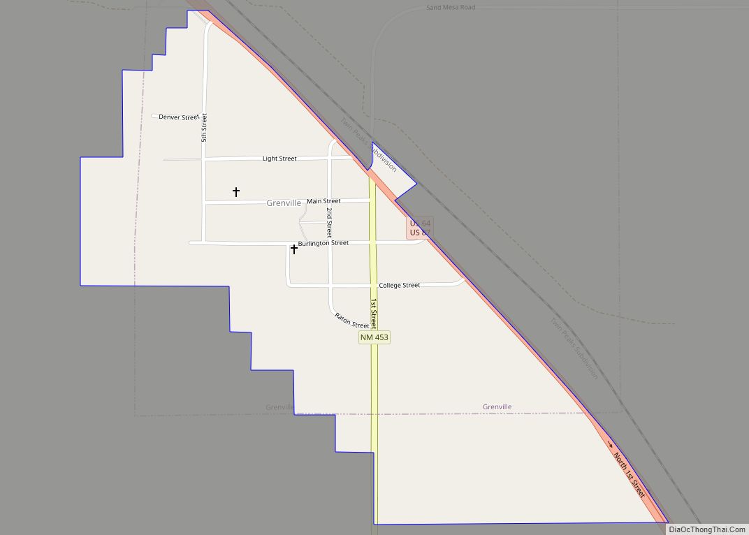
Map of Grady village, New Mexico

Map of Grady village, New Mexico

Grady is a village in Curry County, New Mexico, United States. The population was 107 at the 2010 census. Grady village overview: Name: Grady village LSAD Code: 47 LSAD Description: village (suffix) State: New Mexico County: Curry County Elevation: 4,600 ft (1,402 m) Total Area: 0.27 sq mi (0.69 km²) Land Area: 0.27 sq mi (0.69 km²) Water Area: 0.00 sq mi (0.00 km²) Total Population: … Read more

Map of Golden CDP, New Mexico

Map of Golden CDP, New Mexico

Golden is a census-designated place (CDP) located between the towns of Cedar Crest and Madrid in Santa Fe County, New Mexico, United States. Golden CDP overview: Name: Golden CDP LSAD Code: 57 LSAD Description: CDP (suffix) State: New Mexico County: Santa Fe County Elevation: 6,637 ft (2,023 m) Total Area: 6.73 sq mi (17.42 km²) Land Area: 6.73 sq mi (17.42 km²) Water … Read more

Map of Homestead CDP, New Mexico

Map of Homestead CDP, New Mexico

Homestead is a census-designated place in Catron County, New Mexico, United States. Its population was 47 as of the 2010 census. Homestead CDP overview: Name: Homestead CDP LSAD Code: 57 LSAD Description: CDP (suffix) State: New Mexico County: Catron County Elevation: 7,664 ft (2,336 m) Total Area: 1.17 sq mi (3.04 km²) Land Area: 1.17 sq mi (3.03 km²) Water Area: 0.00 sq mi (0.00 km²) … Read more

Map of Holloman AFB CDP

Map of Holloman AFB CDP

Holloman Air Force Base (IATA: HMN, ICAO: KHMN, FAA LID: HMN) is a United States Air Force base established in 1942 located six miles (10 km) southwest of the central business district of Alamogordo, and a census-designated place in Otero County, New Mexico, United States. The base was named in honor of Col. George V. Holloman, … Read more

Map of Hobbs city

Map of Hobbs city

Hobbs is a city in Lea County, New Mexico, United States. Its population was 40,508 at the 2020 census, increasing from 34,122 in 2010. Hobbs is the principal city of the Hobbs, New Mexico micropolitan statistical area, which includes all of Lea County. Hobbs city overview: Name: Hobbs city LSAD Code: 25 LSAD Description: city … Read more

Map of Hillsboro CDP, New Mexico

Map of Hillsboro CDP, New Mexico

Hillsboro is an unincorporated community in Sierra County, New Mexico, United States, located in the southwestern part of the state. It was founded in 1877, following the discovery of gold. The community was the county seat of Sierra County from 1884 until 1936, when Hot Springs (now called Truth or Consequences) became the county seat. … Read more

Map of Highland Meadows CDP

Map of Highland Meadows CDP

Highland Meadows is a census-designated place in Valencia County, New Mexico, United States. Its population was 624 as of the 2010 census. Highland Meadows CDP overview: Name: Highland Meadows CDP LSAD Code: 57 LSAD Description: CDP (suffix) State: New Mexico County: Valencia County Elevation: 5,492 ft (1,674 m) Total Area: 6.93 sq mi (17.94 km²) Land Area: 6.92 sq mi (17.94 km²) Water … Read more

Map of High Rolls CDP

Map of High Rolls CDP

High Rolls is an unincorporated community and census-designated place in Otero County, New Mexico, United States. It is nestled within the Lincoln National Forest at the southernmost tip of the Sacramento Mountains. High Rolls includes a general store, a post office, an elementary school, two churches, and sometimes a bar. High Rolls has many local … Read more

Map of Hurley town, New Mexico

Map of Hurley town, New Mexico

Hurley is a town in Grant County, New Mexico, United States. The population was 1,297 at the 2010 census, down from 1,464 in 2000. Hurley town overview: Name: Hurley town LSAD Code: 43 LSAD Description: town (suffix) State: New Mexico County: Grant County Elevation: 5,722 ft (1,744 m) Total Area: 1.02 sq mi (2.65 km²) Land Area: 1.02 sq mi (2.64 km²) Water … Read more

Map of House village

Map of House village

House is a village in Quay County, New Mexico, United States. The population was 68 at the 2010 census. House village overview: Name: House village LSAD Code: 47 LSAD Description: village (suffix) State: New Mexico County: Quay County Elevation: 4,705 ft (1,434 m) Total Area: 0.91 sq mi (2.37 km²) Land Area: 0.91 sq mi (2.37 km²) Water Area: 0.00 sq mi (0.00 km²) Total Population: … Read more

Map of Hot Springs Landing CDP

Map of Hot Springs Landing CDP

Hot Springs Landing is a census-designated place in Sierra County, New Mexico, United States. Its population was 110 as of the 2010 census. The community is located on the western shore of Elephant Butte Reservoir. Hot Springs Landing CDP overview: Name: Hot Springs Landing CDP LSAD Code: 57 LSAD Description: CDP (suffix) State: New Mexico … Read more

Map of Hope village, New Mexico

Map of Hope village, New Mexico

Hope is a village in Eddy County, New Mexico, United States. It is located approximately 20 miles (32 km) west of Artesia on U.S. Route 82. It has had a post office since 1890. As of the 2010 census, the village’s population was 105. Hope village overview: Name: Hope village LSAD Code: 47 LSAD Description: village … Read more