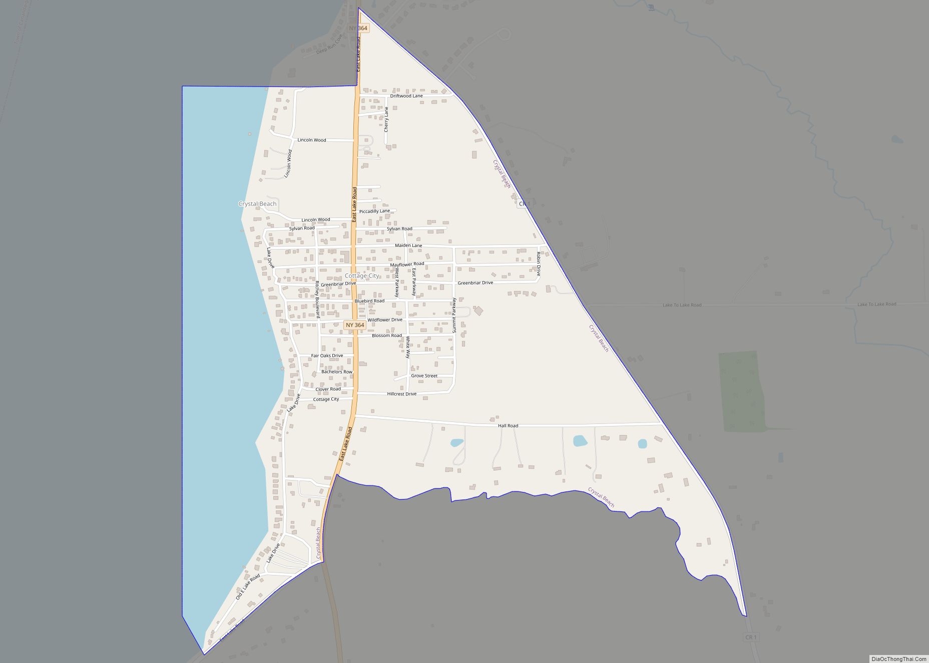
Map of Croghan village

Map of Croghan village

Croghan is a village in Lewis County, New York, United States. Its population was 618 at the 2010 census. The village is situated mainly in the southern part of the town of Croghan, with a small part in New Bremen. The town and the village were both named after George Croghan, a soldier in the … Read more

Map of Cranberry Lake CDP

Map of Cranberry Lake CDP

Cranberry Lake is a hamlet in the eastern part of the Town of Clifton, in St. Lawrence County, New York, United States. It lies along New York State Route 3 on the north shore of Cranberry Lake. The population was 200 at the 2010 census, which lists the community as a census-designated place. Cranberry Lake, … Read more

Map of Cumminsville CDP

Map of Cumminsville CDP

Cumminsville is a hamlet and census-designated place in the town of North Dansville, Livingston County, New York, United States. Its population was 183 as of the 2010 census. It is on the northwest edge of the village of Dansville, and Interstate 390 and New York State Route 36 pass through the community. Cumminsville CDP overview: … Read more

Map of Delanson village

Map of Delanson village

Delanson is a village in Schenectady County, New York, United States. The population was 377 at the 2010 census. Delanson is in the southeastern portion of the town of Duanesburg. Delanson village overview: Name: Delanson village LSAD Code: 47 LSAD Description: village (suffix) State: New York County: Schenectady County Elevation: 817 ft (249 m) Total Area: 0.65 sq mi … Read more

Map of DeKalb Junction CDP

Map of DeKalb Junction CDP

DeKalb Junction is a hamlet and census-designated place located in the town of DeKalb in Saint Lawrence County, New York, United States. Its population was 519 as of the 2010 census. DeKalb Junction has a post office with ZIP code 13630. U.S. Route 11 passes through the community. DeKalb Junction CDP overview: Name: DeKalb Junction … Read more

Map of Deferiet village

Map of Deferiet village

Deferiet is a village in Jefferson County, New York, United States. The population was 294 at the 2010 census. The village is named after settler Jenika de Ferriet. Deferiet is on the southwestern side of the town of Wilna, east of Watertown and south of Fort Drum. Deferiet village overview: Name: Deferiet village LSAD Code: … Read more

Map of Deer Park CDP, New York

Map of Deer Park CDP, New York

Deer Park is a hamlet and census-designated place (CDP) in the Town of Babylon, in Suffolk County, on Long Island, in New York, United States. The population was 27,745 at the 2010 census. Deer Park CDP overview: Name: Deer Park CDP LSAD Code: 57 LSAD Description: CDP (suffix) State: New York County: Suffolk County Elevation: … Read more

Map of Davenport Center CDP

Map of Davenport Center CDP

Davenport Center is a hamlet and census-designated place (CDP) in the town of Davenport, Delaware County, New York, United States. The population was 349 at the 2010 census. Davenport Center CDP overview: Name: Davenport Center CDP LSAD Code: 57 LSAD Description: CDP (suffix) State: New York County: Delaware County Elevation: 1,221 ft (372 m) Total Area: 3.14 sq mi … Read more

Map of Dansville village, New York

Map of Dansville village, New York

Dansville is a village in the town of North Dansville, with a small northern part in the town of Sparta in Livingston County, in western New York, United States. As of the 2020 census, the village population was 4,433. The village is named after Daniel Faulkner, an early European-American settler. Interstate 390 passes the west … Read more

Map of Dannemora village

Map of Dannemora village

Dannemora is a village located in the towns of Dannemora and Saranac in Clinton County, New York, United States. It is best known as the location for Clinton Correctional Facility, also known colloquially as Dannemora. The population was 3,936 (approximately 2,800 to 3,000 of this number are prison inmates) at the 2010 census. The village … Read more

Map of Dalton CDP, New York

Map of Dalton CDP, New York

Dalton is a hamlet and census-designated place (CDP) in the towns of Nunda and Portage in Livingston County, New York, United States. The population was 362 at the 2010 census. Dalton CDP overview: Name: Dalton CDP LSAD Code: 57 LSAD Description: CDP (suffix) State: New York County: Livingston County Elevation: 1,360 ft (410 m) Total Area: 0.76 sq mi … Read more

Map of Cuylerville CDP

Map of Cuylerville CDP

Cuylerville is a hamlet in the Town of Leicester, in Livingston County, New York, United States. The population was 297 at the 2010 census, which lists the community as a census-designated place. Cuylerville CDP overview: Name: Cuylerville CDP LSAD Code: 57 LSAD Description: CDP (suffix) State: New York County: Livingston County Elevation: 571 ft (174 m) Total … Read more