Map of East Hampton village, New York

Map of East Hampton village, New York

The Village of East Hampton is a village in Suffolk County, New York. It is located in the town of East Hampton on the South Fork of eastern Long Island. The population was 1,083 at the time of the 2010 census, 251 less than in the year 2000. It is a center of the summer … Read more

Map of East Hampton North CDP

Map of East Hampton North CDP

East Hampton North is a census-designated place (CDP) in Suffolk County, New York, United States. At the 2010 census, the population was 4,142. East Hampton North CDP overview: Name: East Hampton North CDP LSAD Code: 57 LSAD Description: CDP (suffix) State: New York County: Suffolk County Total Area: 5.57 sq mi (14.43 km²) Land Area: 5.57 sq mi (14.43 km²) Water … Read more

Map of East Greenbush CDP

Map of East Greenbush CDP

East Greenbush is a census-designated place (CDP) in Rensselaer County, New York, United States. The population was 4,487 at the 2010 census. East Greenbush is mostly within the southern part of the town of East Greenbush, but a small section of the community extends southward into the town of Schodack. U.S. Routes 9 and 20 … Read more

Map of East Glenville CDP

Map of East Glenville CDP

East Glenville is a hamlet (and a census-designated place) in Schenectady County, New York, United States. The population was 6,616 at the 2010 census. The CDP includes the adjacent hamlet of Alplaus. East Glenville is in the town of Glenville. East Glenville CDP overview: Name: East Glenville CDP LSAD Code: 57 LSAD Description: CDP (suffix) … Read more

Map of East Farmingdale CDP

Map of East Farmingdale CDP

East Farmingdale is a hamlet and a census-designated place (CDP) in Suffolk County, on Long Island, in New York. The population of the CDP was 6,484 at the 2010 census. Located in the Town of Babylon, the residents are served by the Farmingdale Post Office. In the past, some or all East Farmingdale was proposed … Read more

Map of East Avon CDP

Map of East Avon CDP

East Avon is a hamlet and census-designated place (CDP) in the town of Avon, Livingston County, New York, United States. The population was 608 at the 2010 census. East Avon CDP overview: Name: East Avon CDP LSAD Code: 57 LSAD Description: CDP (suffix) State: New York County: Livingston County Elevation: 825 ft (251 m) Total Area: 1.31 sq mi … Read more

Map of East Aurora village

Map of East Aurora village

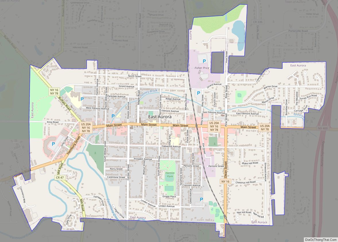
East Aurora is a village in Erie County, New York, United States, southeast of Buffalo. It lies in the eastern half of the town of Aurora. The village population was 5,998 per the 2020 census. It is part of the Buffalo–Niagara Falls Metropolitan Statistical Area. In 2015, East Aurora was rated the third-best town to … Read more

Map of East Nassau village

Map of East Nassau village

East Nassau is a village in Rensselaer County, New York, United States. The population was 587 at the 2010 census. The Village of East Nassau is in the eastern section of the town of Nassau along the Town of Stephentown border by Routes 20 and 66. East Nassau village overview: Name: East Nassau village LSAD … Read more

Map of East Moriches CDP

Map of East Moriches CDP

East Moriches (/moʊˈrɪtʃɪz/ (listen) moh-RITCH-iz) is a hamlet and census-designated place in the Town of Brookhaven, Suffolk County, New York, United States. The population was 5,249 at the 2010 census. The name Moriches comes from Meritces, a Native American who owned land on Moriches Neck. East Moriches CDP overview: Name: East Moriches CDP LSAD Code: … Read more

Map of East Meadow CDP

Map of East Meadow CDP

East Meadow is a hamlet and census-designated place (CDP) in the Town of Hempstead in Nassau County, on Long Island, in New York. The population was 38,132 at the 2010 census. Many residents commute to Manhattan, which is 30 miles (48 km) away. East Meadow CDP overview: Name: East Meadow CDP LSAD Code: 57 LSAD Description: … Read more

Map of East Massapequa CDP

Map of East Massapequa CDP

East Massapequa (formerly known as West Amityville) is a hamlet and census-designated place (CDP) located within the Town of Oyster Bay in Nassau County, on the South Shore of Long Island, in New York, United States. The population was 19,069 at the 2010 census. East Massapequa CDP overview: Name: East Massapequa CDP LSAD Code: 57 … Read more

Map of East Marion CDP

Map of East Marion CDP

East Marion is a census-designated place (CDP) that roughly corresponds to the hamlet by the same name in the town of Southold in Suffolk County, New York, United States. The CDP population was 926 at the 2010 census. East Marion CDP overview: Name: East Marion CDP LSAD Code: 57 LSAD Description: CDP (suffix) State: New … Read more