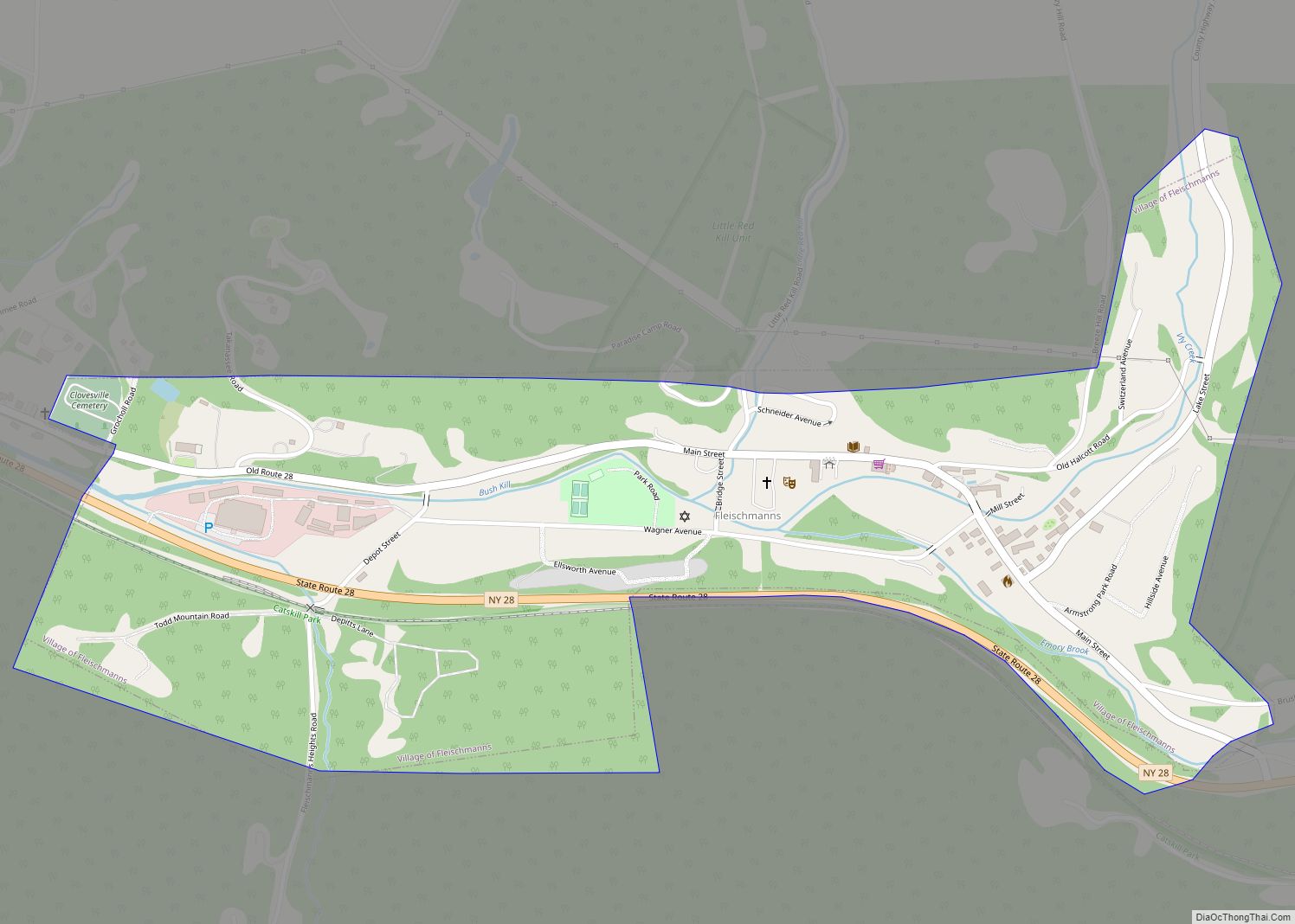
Map of Fort Ann village

Map of Fort Ann village

Fort Ann is a village in Washington County, New York, United States. It is part of the Glens Falls Metropolitan Statistical Area. The village population was 484 at the 2010 census. The name is derived indirectly from Queen Anne and the local fortification built in 1757 and named after her. The village of Fort Ann … Read more

Map of Forestville CDP, New York

Map of Forestville CDP, New York

Forestville is a hamlet (and census-designated place) in Chautauqua County, New York, United States. The population was 697 at the 2010 census. The hamlet is within the town of Hanover and in the northeast part of the county. It was an incorporated village from 1848 to 2016. Forestville CDP overview: Name: Forestville CDP LSAD Code: … Read more

Map of Forest Home CDP

Map of Forest Home CDP

Forest Home is a census-designated place (CDP) in Tompkins County, New York, United States. The population was 572 at the 2010 census. The community of Forest Home is in the Town of Ithaca, northeast of the City of Ithaca and north of Cornell University. Forest Home CDP overview: Name: Forest Home CDP LSAD Code: 57 … Read more

Map of Fonda village, New York

Map of Fonda village, New York

Fonda is a village in and the county seat of Montgomery County, New York, United States. The population was 795 at the 2010 census. The village is named after Douw Fonda, a Dutch-American settler who was killed and scalped in 1780, during a Mohawk raid in the Revolutionary War, when the tribe was allied with … Read more

Map of Flower Hill village

Map of Flower Hill village

Flower Hill is a village in Nassau County, on the North Shore of Long Island, in New York, United States. The eastern half is considered part of the Greater Roslyn area, which is anchored by the Incorporated Village of Roslyn. Western and northern parts are more closely associated with Manhasset and Port Washington. The population … Read more

Map of Franklin village, New York

Map of Franklin village, New York

Franklin is a village in Delaware County of the U.S. state of New York. As of the 2010 census, the village population was 374. The village is in the town of Franklin. The area was not settled by European Americans until after the Revolutionary War, when pioneers came from New England, downstate, and as new … Read more

Map of Franklin Square CDP

Map of Franklin Square CDP

Franklin Square is a hamlet and census-designated place (CDP) in Nassau County, New York, United States. The hamlet is an unincorporated area in the Town of Hempstead. The population was 29,320 at the 2010 census. The area was originally known as Trimming Square and then as Washington Square. Franklin Square CDP overview: Name: Franklin Square … Read more

Map of Frankfort village, New York

Map of Frankfort village, New York

Frankfort is a village in the town of Frankfort, Herkimer County, New York, United States. The population was 2,598 at the 2010 census, out of 7,636 people in the entire town. Like the town, the village is named after an early settler, Lawrence (Lewis) Frank. Frankfort is on the south side of the Erie Canal … Read more

Map of Fowlerville CDP, New York

Map of Fowlerville CDP, New York

Fowlerville is a hamlet and census-designated place (CDP) in the town of York in Livingston County, New York, United States. The population of the CDP was 227 at the 2010 census. The community is named for Wells Fowler, the first settler. It should not be confused with other New York hamlets named Fowlerville in Erie … Read more

Map of Fort Salonga CDP

Map of Fort Salonga CDP

Fort Salonga is a hamlet and census-designated place (CDP) in the Towns of Huntington and Smithtown in Suffolk County, on the North Shore of Long Island, in New York, United States. The population was 10,008 at the 2010 census. The hamlet is considered the easternmost part of the historic Gold Coast of Long Island, with … Read more

Map of Fort Plain village

Map of Fort Plain village

Fort Plain is a village in Montgomery County, New York, United States. As of the 2010 census, the village population was 2,322. The village is named after a fort built during the American Revolution at the junction of the Mohawk River and its tributary Otsquago Creek. The village of Fort Plain is at the border … Read more

Map of Fort Montgomery CDP

Map of Fort Montgomery CDP

Fort Montgomery is a hamlet (and census-designated place) in Orange County, New York, United States. The population was 1,627 at the 2020 census. It is part of the Poughkeepsie–Newburgh–Middletown, NY Metropolitan Statistical Area as well as the larger New York–Newark–Bridgeport, NY-NJ–CT–PA Combined Statistical Area. Fort Montgomery is in the southeastern corner of the town of … Read more