Map of Peekskill city

Map of Peekskill city

Peekskill is a city in northwestern Westchester County, New York, United States, 35 miles (56 km) from New York City. Established as a village in 1816, it was incorporated as a city in 1940. It lies on a bay along the east side of the Hudson River, across from Jones Point in Rockland County. The population … Read more

Map of Peconic CDP

Map of Peconic CDP

Peconic is a census-designated place (CDP) that roughly corresponds to the hamlet by the same name in the Town of Southold in Suffolk County, New York, United States. The CDP population was 683 at the 2010 census. Peconic CDP overview: Name: Peconic CDP LSAD Code: 57 LSAD Description: CDP (suffix) State: New York County: Suffolk … Read more

Map of Pearl River CDP, New York

Map of Pearl River CDP, New York

Pearl River is a hamlet and census-designated place in the town of Orangetown, Rockland County, New York, United States. It is east of Chestnut Ridge, south of Nanuet, west of Blauvelt, New York, and north of Montvale and Old Tappan, New Jersey. The population was 15,876 at the 2010 census. Pearl River is 20 miles … Read more

Map of Peach Lake CDP

Map of Peach Lake CDP

Peach Lake is a hamlet (and census-designated place) located mostly in the town of Southeast in Putnam County, New York, United States; a portion of the CDP is in the town of North Salem in Westchester County. As of the 2010 census, the population was 1,629. The community of Peach Lake is located on the … Read more

Map of Pawling village

Map of Pawling village

Pawling is a village in Dutchess County, New York, United States. The population was 2,347 at the 2010 census. It is part of the Poughkeepsie–Newburgh–Middletown, NY Metropolitan Statistical Area as well as the larger New York–Newark–Bridgeport, NY-NJ–CT–PA Combined Statistical Area. The John Kane House, a registered historic place, is situated in the village. The village … Read more

Map of Pavilion CDP

Map of Pavilion CDP

Pavilion is a hamlet and census-designated place within the town of Pavilion in Genesee County, New York, United States. As of the 2010 census, the population of the CDP was 646, out of a total of 2,495 people in the town as a whole. Pavilion CDP overview: Name: Pavilion CDP LSAD Code: 57 LSAD Description: … Read more

Map of Perry village, New York

Map of Perry village, New York

Perry is a village in the towns of Perry and Castile in Wyoming County, New York, United States. The population was 3,673 at the 2010 census. The village is at the junction of state routes 39 and 246. Perry village overview: Name: Perry village LSAD Code: 47 LSAD Description: village (suffix) State: New York County: … Read more

Map of Penn Yan village

Map of Penn Yan village

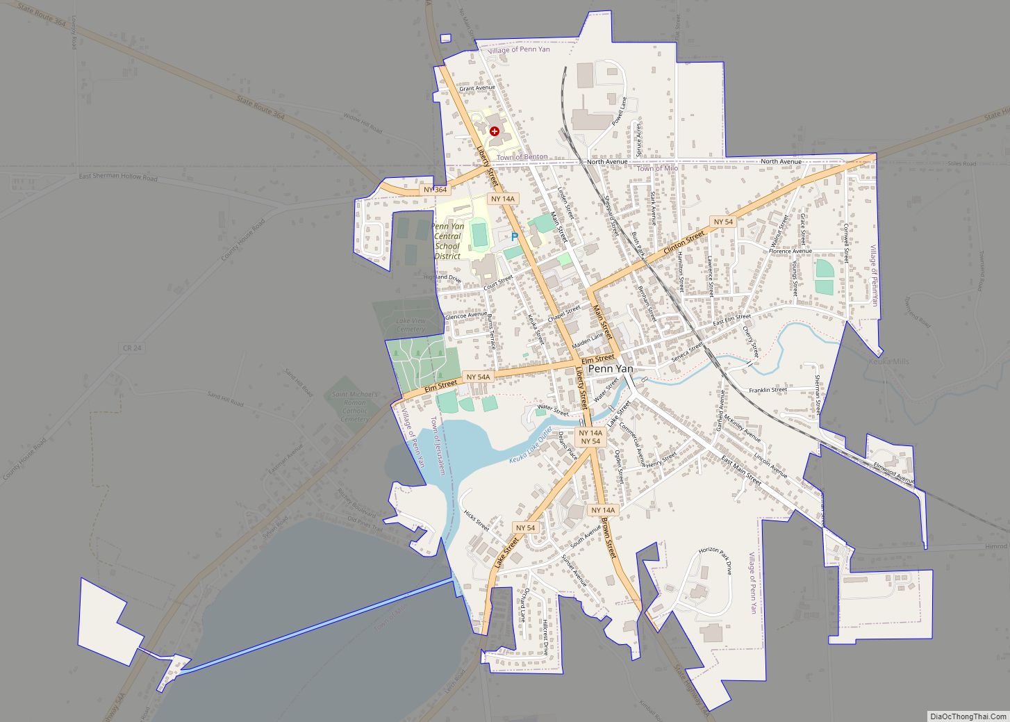
Penn Yan is an incorporated village and the county seat of Yates County, New York, United States. The population was 5,159 at the 2010 census. It lies at the north end of the east branch of Keuka Lake, one of the Finger Lakes. Penn Yan, New York is home to one of the oldest mills … Read more

Map of Pelham village, New York

Map of Pelham village, New York

The village of Pelham is a village in Westchester County, New York, United States. The population was 6,910 at the 2010 census. It is located in the town of Pelham, which is colloquially referred to as Pelham. Pelham village overview: Name: Pelham village LSAD Code: 47 LSAD Description: village (suffix) State: New York County: Westchester … Read more

Map of Piffard CDP

Map of Piffard CDP

Piffard is a census-designated place (CDP) and hamlet in the town of York, Livingston County, New York, United States. As of the 2010 census, its population was 220. The ZIP Code is 14533. Piffard CDP overview: Name: Piffard CDP LSAD Code: 57 LSAD Description: CDP (suffix) State: New York County: Livingston County Elevation: 568 ft (173 m) … Read more

Map of Pierrepont Manor CDP

Map of Pierrepont Manor CDP

Pierrepont Manor is a hamlet and census-designated place (CDP) in Jefferson County, New York, United States. Its population was 228 as of the 2010 census. Pierrepont Manor has a post office with ZIP code 13674, which opened on November 29, 1843. U.S. Route 11 and New York State Route 193 intersect in the community; it … Read more

Map of Piermont village

Map of Piermont village

Piermont is a village incorporated in 1847 in Rockland County, New York, United States. Piermont is in the town of Orangetown, located north of the hamlet of Palisades, east of Sparkill, and south of Grand View-on-Hudson, on the west bank of the Hudson River. The population was 2,510 at the 2010 census. Woody Allen set … Read more