Map of Ransomville CDP

Map of Ransomville CDP

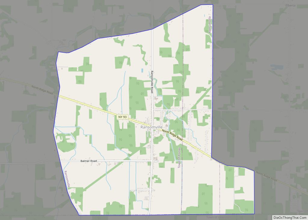
Ransomville is a hamlet (and census-designated place) located in the Town of Porter in Niagara County, New York, United States. The population was 1,419 at the 2010 census. Portions of the hamlet are also in Town of Wilson and Town of Cambria. Ransomville is north of the City of Niagara Falls and is part of … Read more

Map of Randolph CDP, New York

Map of Randolph CDP, New York

Randolph is a hamlet, census-designated place (CDP) and former village in Cattaraugus County, New York, United States. It is located within the town of Randolph. The population of the village was 1,286 at the 2010 census, out of 2,602 in the town as a whole. Randolph borders the community of East Randolph. Randolph CDP overview: … Read more

Map of Quogue village

Map of Quogue village

Quogue (/kwɒɡ/) is a village in the Town of Southampton in Suffolk County, on the South Fork of Long Island, in New York, United States. As of the 2010 United States Census, the population was 967, down from 1,018 at the 2000 census. Quogue village overview: Name: Quogue village LSAD Code: 47 LSAD Description: village … Read more

Map of Quiogue CDP

Map of Quiogue CDP

Quiogue /ˈkwiːɒɡ/ is a hamlet and census-designated place (CDP) in the Town of Southampton, in Suffolk County, New York, United States. The population was 816 at the 2010 census. The name of the CDP was corrected from “Quioque” to “Quiogue” by the U.S. Census Bureau in 2010. Quiogue CDP overview: Name: Quiogue CDP LSAD Code: … Read more

Map of Putnam Lake CDP

Map of Putnam Lake CDP

Putnam Lake is a hamlet and census-designated place in the eastern part of the town of Patterson in Putnam County, New York, United States. As of the 2010 census, the population was 3,844. Putnam Lake is adjacent to the Connecticut border, which is crossed by a number of local streets. The community surrounds a lake, … Read more

Map of Pultneyville CDP

Map of Pultneyville CDP

Pultneyville is a hamlet (and census-designated place) located in the Town of Williamson, Wayne County, New York, United States. The population was 698 at the 2010 census. Pultneyville frames the mouth of Salmon Creek on the northern border of the town, and is situated on the southern shore of Lake Ontario. The hamlet was originally … Read more

Map of Pulaski village, New York

Map of Pulaski village, New York

Pulaski (/pəˈlæskaɪ/) is a village in Oswego County, New York, United States. The population was 2,365 at the 2010 census. The Village of Pulaski is within the Town of Richland, and lies between the eastern shore of Lake Ontario and the Tug Hill region. The village is located on U.S. Route 11 and is adjacent … Read more

Map of Prospect CDP, New York

Map of Prospect CDP, New York

Prospect is a hamlet in the town of Trenton, in Oneida County, New York, United States. The population was 291 at the 2010 census. The hamlet is located at the junction of NY 365 and Reference Route 920V west of West Canada Creek. It was an incorporated village from 1890 to 2015. Prospect CDP overview: … Read more

Map of Preston-Potter Hollow CDP

Map of Preston-Potter Hollow CDP

Preston-Potter Hollow is a census-designated place (CDP) in Albany County, New York, United States. The population was 366 at the 2010 census. Preston and Potter Hollow are two hamlets in the town of Rensselaerville, located in the southwestern corner of Albany County. The communities are near the border of Greene County. Preston-Potter Hollow CDP overview: … Read more

Map of Redford CDP

Map of Redford CDP, New York

Redford is a hamlet and census-designated place in the town of Saranac in Clinton County, New York, United States. The population was 477 at the 2010 census. Redford is in the southern part of the town and is west of Plattsburgh. It is within the Adirondack Park. Redford CDP overview: Name: Redford CDP LSAD Code: … Read more

Map of Red Oaks Mill CDP

Map of Red Oaks Mill CDP

Red Oaks Mill is a hamlet and census-designated place (CDP) in Dutchess County, in the U.S. state of New York. It lies within the limits of the towns of Poughkeepsie and LaGrange. The population was 3,613 at the 2010 census. Red Oaks Mill is southeast of the city of Poughkeepsie and can be considered a … Read more

Map of Red Hook village

Map of Red Hook village, New York

Red Hook is a village in Dutchess County, New York, United States. The population was 1,961 at the 2010 census. It is part of the Poughkeepsie–Newburgh–Middletown, NY Metropolitan Statistical Area as well as the larger New York–Newark–Bridgeport, NY-NJ–CT–PA Combined Statistical Area. The name is derived from the Dutch “Roode Hoeck” – hoeck meaning peninsula, and … Read more