Map of Titusville CDP, New York
Titusville is a hamlet and census-designated place in the town of LaGrange, New York, in Dutchess County, United States. As of the 2010 census, it had a population of 811. Titusville CDP overview: Name: Titusville CDP LSAD Code: 57 LSAD Description: CDP (suffix) State: New York County: Dutchess County Elevation: 220 ft (67 m) Total Area: 0.69 sq mi ... Read more
Map of Titusville CDP, New York
Map of Tillson CDP
Tillson is a hamlet (and census-designated place) in Ulster County, New York, United States. The population was 1,516 at the 2020 census. Tillson is in the Town of Rosendale, along routes 32 and 213. Tillson CDP overview: Name: Tillson CDP LSAD Code: 57 LSAD Description: CDP (suffix) State: New York County: Ulster County Elevation: 233 ft ... Read more
Map of Tillson CDP
Map of Ticonderoga CDP
Ticonderoga (/taɪkɒndəˈroʊɡə/) is a hamlet in the southeast part of the town of Ticonderoga, in Essex County, New York, United States. The name is derived from the Haudenosaunee term for “between the two waters”, the two waters being Lake George and Lake Champlain. The hamlet became a census-designated place (CDP) in 2008. As of the ... Read more
Map of Ticonderoga CDP
Map of Three Mile Bay CDP
Three Mile Bay is a hamlet and census-designated place (CDP) in the town of Lyme in Jefferson County, New York, United States. The elevation is 259 feet (79 m). As of the 2010 census it had a population of 227. The hamlet has its own post office, a volunteer fire company, and boat launches for fishing ... Read more
Map of Three Mile Bay CDP
Map of Thousand Island Park CDP
Thousand Island Park, also known as TI Park, is a hamlet and census-designated place (CDP) in the town of Orleans, Jefferson County, New York, United States, in the Thousand Islands region on the St. Lawrence River. Founded in 1875 as a holiday camp, the incorporated community remains a seasonal summer community; despite 323 housing units, ... Read more
Map of Thousand Island Park CDP
Map of Thornwood CDP
Thornwood is a hamlet (unincorporated community), census-designated place (CDP), and postal designation (with zip code 10594) in the town of Mount Pleasant in Westchester County, New York. The population was 3,759 at the 2010 census. Thornwood CDP overview: Name: Thornwood CDP LSAD Code: 57 LSAD Description: CDP (suffix) State: New York County: Westchester County Elevation: ... Read more
Map of Thornwood CDP
Map of Thomaston village, New York
Thomaston is a village in eastern Great Neck in the Town of North Hempstead in Nassau County, on the North Shore of Long Island, in New York, United States. The population was 2,617 at the 2010 census. Thomaston village overview: Name: Thomaston village LSAD Code: 47 LSAD Description: village (suffix) State: New York County: Nassau ... Read more
Map of Thomaston village, New York
Map of Town Line CDP
Town Line is a hamlet and census-designated place (CDP) in Erie County, New York, United States. The population was 2,367 at the 2010 census. It is part of the Buffalo–Niagara Falls Metropolitan Statistical Area. The community is located on the boundary between the towns of Lancaster and Alden. Town Line is notable for having held ... Read more
Map of Town Line CDP
Map of Tonawanda CDP
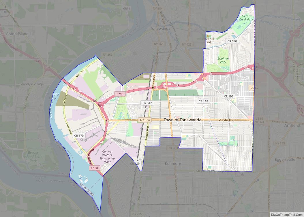
Tonawanda (formally City of Tonawanda) is a city in Erie County, New York, United States. The population was 15,129 at the 2020 census. It is at the northern edge of Erie County, south across the Erie Canal (Tonawanda Creek) from North Tonawanda, east of Grand Island, and north of Buffalo. It is part of the ... Read more
Map of Tonawanda CDP
Map of Unadilla village, New York
Unadilla is a village located in the Town of Unadilla in Otsego County, New York, United States. The population was 1,128 at the 2010 census. The Village of Unadilla is located in the southern part of the town, southwest of Oneonta. The community refers to itself as “The Village Beautiful.” Unadilla village overview: Name: Unadilla ... Read more
Map of Unadilla village, New York
Map of Tuxedo Park village
Tuxedo Park is a village in Orange County, New York, United States. Its population was 645 at the 2020 census. It is part of the Poughkeepsie–Newburgh–Middletown metropolitan area as well as the larger New York metropolitan area. Its name is derived from an indigenous Lenape word of the Munsee language, tucsedo or p’tuxseepu, which is ... Read more
Map of Tuxedo Park village
Map of Tuscarora CDP, New York
Tuscarora is a hamlet and census-designated place in the town of Mount Morris, Livingston County, New York, United States. Its population was 74 as of the 2010 census. Tuscarora CDP overview: Name: Tuscarora CDP LSAD Code: 57 LSAD Description: CDP (suffix) State: New York County: Livingston County Elevation: 750 ft (230 m) Total Area: 0.09 sq mi (0.24 km²) Land ... Read more
Map of Tuscarora CDP, New York