Map of Pembina city
Pembina (/ˈpɛmbɪnə/ (listen)) is a city in Pembina County, North Dakota, United States. The population was 512 at the 2020 census. Pembina is located 2 miles (3.2 km) south of the Canada–US border. Interstate 29 passes on the west side of Pembina, leading north to the Canada–US border at Emerson, Manitoba and south to the cities ... Read more
Map of Pembina city
Map of Pekin city, North Dakota
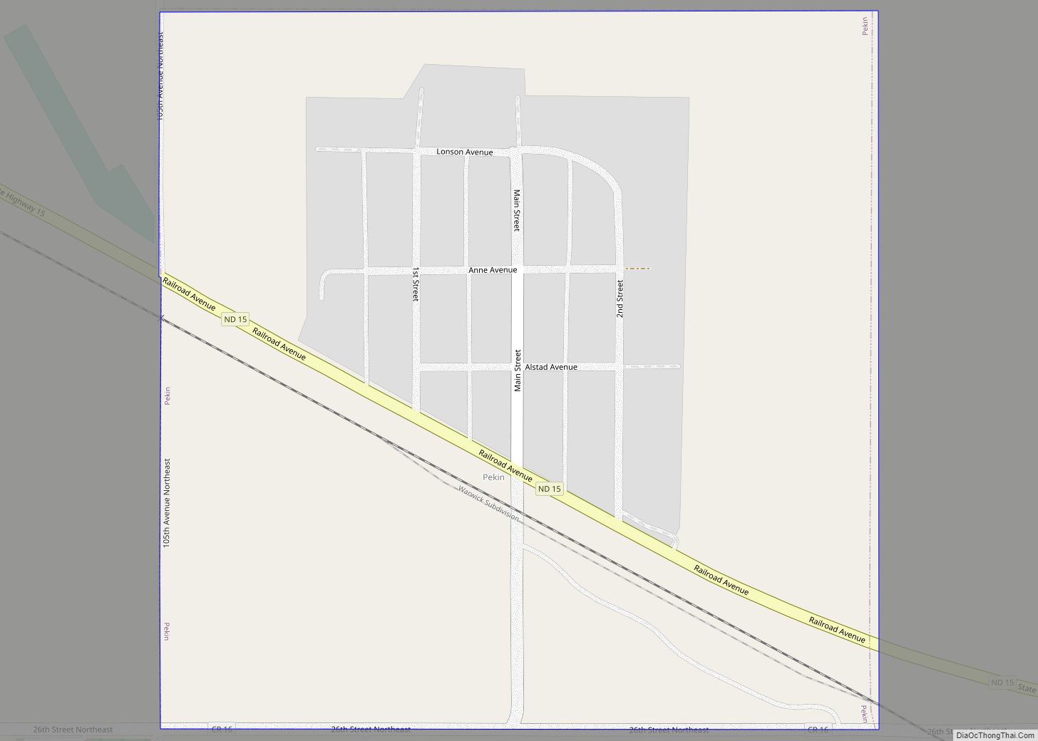
Pekin (/ˈpiːkɪn/ PEEK-in) is a city in Nelson County, North Dakota, United States. The population was 75 at the 2020 census. The first European settlers immigrated to the area in the mid-19th century and Pekin was founded in 1906. Pekin city overview: Name: Pekin city LSAD Code: 25 LSAD Description: city (suffix) State: North Dakota ... Read more
Map of Pekin city, North Dakota
Map of Parshall city, North Dakota
Parshall (Hidatsa: dibiarugareesh) is a city lying within the jurisdictional boundaries of the Mandan, Hidatsa, and Arikara Nation. It is located on the Fort Berthold Indian Reservation in Mountrail County, North Dakota, United States. The population was 949 at the 2020 census. Parshall was founded in 1914 by George Parshall, and is the home of ... Read more
Map of Parshall city, North Dakota
Map of Park River city
Park River is a city in Walsh County, North Dakota, United States. The population was 1,424 at the 2020 census. Park River was founded in 1884. In 1903, a Park River blacksmith named Samuel Holland built a motor car called the Holland Special. He built at least five more cars between 1903 and 1908. Park ... Read more
Map of Park River city
Map of Palermo city, North Dakota
Palermo (/ˈpælərmoʊ/ PAL-ər-moh) is a city in Mountrail County, North Dakota, United States. The population was 125 at the 2020 census. Palermo city overview: Name: Palermo city LSAD Code: 25 LSAD Description: city (suffix) State: North Dakota County: Mountrail County Founded: 1902 Elevation: 2,208 ft (673 m) Total Area: 2.25 sq mi (5.84 km²) Land Area: 2.25 sq mi (5.83 km²) Water Area: ... Read more
Map of Palermo city, North Dakota
Map of Page city, North Dakota
Page is a city in Cass County, North Dakota, United States. The population was 190 at the 2020 census. Page was founded in 1882. Page city overview: Name: Page city LSAD Code: 25 LSAD Description: city (suffix) State: North Dakota County: Cass County Elevation: 1,178 ft (359 m) Total Area: 1.00 sq mi (2.60 km²) Land Area: 1.00 sq mi (2.60 km²) Water ... Read more
Map of Page city, North Dakota
Map of Oxbow city, North Dakota
Oxbow is a city in Cass County, North Dakota, United States. The population was 381 at the 2020 census. It is an upscale bedroom community located 15 miles (24 km) south of Fargo. It was incorporated as a city October 25, 1988. Oxbow city overview: Name: Oxbow city LSAD Code: 25 LSAD Description: city (suffix) State: ... Read more
Map of Oxbow city, North Dakota
Map of Overly city
Overly is a city in Bottineau County in the U.S. state of North Dakota. The population was 10 at the 2020 census. Overly city overview: Name: Overly city LSAD Code: 25 LSAD Description: city (suffix) State: North Dakota County: Bottineau County Founded: August 21, 1905 Elevation: 1,542 ft (470 m) Total Area: 0.37 sq mi (0.96 km²) Land Area: 0.37 sq mi ... Read more
Map of Overly city
Map of Plaza city
Plaza is a city in Mountrail County, North Dakota, United States. The population was 211 at the 2020 census. Plaza was founded in 1906. The business district is built around a central town square, city park or “plaza”. A key feature of the plaza is a recently completed large covered gazebo. Plaza city overview: Name: ... Read more
Map of Plaza city
Map of Pisek city
Pisek (/ˈpiːsɪk/ PEES-ik) is a city in Walsh County, North Dakota, United States. The population was 89 at the 2020 census. Pisek city overview: Name: Pisek city LSAD Code: 25 LSAD Description: city (suffix) State: North Dakota County: Walsh County Founded: 1882 Elevation: 988 ft (301 m) Total Area: 0.11 sq mi (0.30 km²) Land Area: 0.11 sq mi (0.30 km²) Water Area: ... Read more
Map of Pisek city
Map of Pingree city
Pingree is a city in Stutsman County, North Dakota, United States. The population was 41 at the 2020 census. Pingree was founded in 1882. Pingree city overview: Name: Pingree city LSAD Code: 25 LSAD Description: city (suffix) State: North Dakota County: Stutsman County Elevation: 1,558 ft (475 m) Total Area: 0.19 sq mi (0.50 km²) Land Area: 0.19 sq mi (0.50 km²) Water ... Read more
Map of Pingree city
Map of Pillsbury city
Pillsbury is a city in Barnes County, North Dakota, United States. The population was 12 at the 2020 census. Pillsbury was founded in 1911. Pillsbury city overview: Name: Pillsbury city LSAD Code: 25 LSAD Description: city (suffix) State: North Dakota County: Barnes County Founded: 1911 Elevation: 1,280 ft (390 m) Total Area: 0.26 sq mi (0.66 km²) Land Area: 0.26 sq mi ... Read more
Map of Pillsbury city