Map of Bourneville CDP

Map of Bourneville CDP

Bourneville is a census-designated place in central Twin Township, Ross County, Ohio, United States. It has a post office with the ZIP code 45617. It lies along U.S. Route 50. Bourneville CDP overview: Name: Bourneville CDP LSAD Code: 57 LSAD Description: CDP (suffix) State: Ohio County: Ross County FIPS code: 3907888 Online Interactive Map Bourneville … Read more

Map of Botkins village

Map of Botkins village

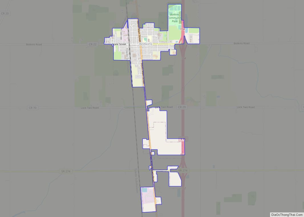
Botkins is a village in Shelby County, Ohio, United States. The population was 1,155 at the 2010 census. Botkins is located alongside Interstate 75 at Exit 104. Botkins is at the northern edge of Shelby County, immediately south of its border with Auglaize County. It also lies at the northern edge of the 937 area … Read more

Map of Boston Heights village

Map of Boston Heights village

Boston Heights is a village in northern Summit County, Ohio, United States. The population was 1,402 at the 2020 census. It is part of the Akron metropolitan area. Boston Heights is home to the headquarters of Arhaus, a major home furnishings retailer. Boston Heights village overview: Name: Boston Heights village LSAD Code: 47 LSAD Description: … Read more

Map of Bolivar village, Ohio

Map of Bolivar village, Ohio

Bolivar (/ˈbɒlɪvər/, rhymes with Oliver) is a village in Tuscarawas County, Ohio, United States. The population was 994 at the 2010 census. Bolivar is also home to Fort Laurens, the only American Revolutionary War-era fort in what is now Ohio. Bolivar village overview: Name: Bolivar village LSAD Code: 47 LSAD Description: village (suffix) State: Ohio … Read more

Map of Bolindale CDP

Map of Bolindale CDP

Bolindale is an unincorporated community and census-designated place in southern Howland Township, Trumbull County, Ohio, United States. The population was 1,921 at the 2020 census. It is part of the Youngstown–Warren metropolitan area. Bolindale CDP overview: Name: Bolindale CDP LSAD Code: 57 LSAD Description: CDP (suffix) State: Ohio County: Trumbull County Elevation: 951 ft (290 m) Total … Read more

Map of Brilliant CDP, Ohio

Map of Brilliant CDP, Ohio

Brilliant is an unincorporated community and census-designated place (CDP) in eastern Jefferson County, Ohio, United States, along the Ohio River. It was named after the Brilliant Glass factory that once was located in the town. The population was 1,317 as of the 2020 census. It is part of the Weirton–Steubenville metropolitan area. Brilliant was formerly … Read more

Map of Bridgetown CDP, Ohio

Map of Bridgetown CDP, Ohio

Bridgetown is a census-designated place (CDP) in Green Township, Hamilton County, Ohio, United States. The population was 14,731 at the 2020 census. In earlier censuses it was listed as the slightly smaller Bridgetown North CDP. Bridgetown CDP overview: Name: Bridgetown CDP LSAD Code: 57 LSAD Description: CDP (suffix) State: Ohio County: Hamilton County Elevation: 900 ft … Read more

Map of Bridgeport village, Ohio

Map of Bridgeport village, Ohio

Bridgeport is a village in eastern Belmont County, Ohio, United States. It lies across the Ohio River from Wheeling, West Virginia, at the mouth of Wheeling Creek and is connected by two bridges to Wheeling Island. The population was 1,582 at the 2020 census. It is part of the Wheeling metropolitan area. Bridgeport village overview: … Read more

Map of Brice village

Map of Brice village

Brice is a village in Franklin County, Ohio, United States, on the southeast side of the Columbus metropolitan area. The population was 93 at the 2020 census. The village theme is “An Early American Village”. The majority of the village’s revenues in 2019 and 2020 were in fines collected with traffic enforcement cameras. Ohio Auditor … Read more

Map of Brewster village, Ohio

Map of Brewster village, Ohio

Brewster is a village in Stark County, Ohio, United States. The population was 2,112 at the 2010 census. It is part of the Canton-Massillon, OH Metropolitan Statistical Area. A post office called Brewster has been in operation since 1910. Brewster village overview: Name: Brewster village LSAD Code: 47 LSAD Description: village (suffix) State: Ohio County: … Read more

Map of Bremen village, Ohio

Map of Bremen village, Ohio

Bremen /ˈbrɛmən/ is a village in Fairfield County, Ohio, United States. The population was 1,425 at the 2010 census. Bremen village overview: Name: Bremen village LSAD Code: 47 LSAD Description: village (suffix) State: Ohio County: Fairfield County Elevation: 768 ft (234 m) Total Area: 0.86 sq mi (2.24 km²) Land Area: 0.86 sq mi (2.23 km²) Water Area: 0.00 sq mi (0.01 km²) Total Population: 1,479 … Read more

Map of Brecon CDP

Map of Brecon CDP

Brecon is a census-designated place (CDP) in Sycamore Township, Hamilton County, Ohio, United States. The population was 408 at the 2020 census. Brecon CDP overview: Name: Brecon CDP LSAD Code: 57 LSAD Description: CDP (suffix) State: Ohio County: Hamilton County Elevation: 870 ft (270 m) Total Area: 0.66 sq mi (1.70 km²) Land Area: 0.66 sq mi (1.70 km²) Water Area: 0.00 sq mi (0.00 km²) … Read more