Map of Felicity village

Map of Felicity village

Felicity is a village in Franklin Township, Clermont County, Ohio, United States. The population was 651 at the 2020 census. Felicity village overview: Name: Felicity village LSAD Code: 47 LSAD Description: village (suffix) State: Ohio County: Clermont County Elevation: 919 ft (280 m) Total Area: 0.26 sq mi (0.68 km²) Land Area: 0.26 sq mi (0.68 km²) Water Area: 0.00 sq mi (0.00 km²) Total Population: … Read more

Map of Fayetteville village, Ohio

Map of Fayetteville village, Ohio

Fayetteville is a village in Perry Township, Brown County, Ohio, United States. The population was 330 at the 2010 census. Fayetteville village overview: Name: Fayetteville village LSAD Code: 47 LSAD Description: village (suffix) State: Ohio County: Brown County Elevation: 948 ft (289 m) Total Area: 0.47 sq mi (1.22 km²) Land Area: 0.47 sq mi (1.22 km²) Water Area: 0.00 sq mi (0.00 km²) Total Population: … Read more

Map of Fayette village, Ohio

Map of Fayette village, Ohio

Fayette is a village in Fulton County, Ohio, United States. The population was 1,283 at the 2010 census. Fayette village overview: Name: Fayette village LSAD Code: 47 LSAD Description: village (suffix) State: Ohio County: Fulton County Elevation: 791 ft (241 m) Total Area: 0.97 sq mi (2.52 km²) Land Area: 0.97 sq mi (2.52 km²) Water Area: 0.00 sq mi (0.00 km²) Total Population: 1,305 Population … Read more

Map of Farmersville village, Ohio

Map of Farmersville village, Ohio

Farmersville is a village in Jackson Township, Montgomery County, Ohio, United States. The population was 975 at the 2020 census. It is part of the Dayton Metropolitan Statistical Area. Farmersville village overview: Name: Farmersville village LSAD Code: 47 LSAD Description: village (suffix) State: Ohio County: Montgomery County Elevation: 879 ft (268 m) Total Area: 0.71 sq mi (1.85 km²) Land … Read more

Map of Fairview village, Ohio

Map of Fairview village, Ohio

Fairview is a village in Belmont and Guernsey counties in the U.S. state of Ohio. The population was 67 as of the 2020 census. It is part of the Wheeling metropolitan area. Fairview village overview: Name: Fairview village LSAD Code: 47 LSAD Description: village (suffix) State: Ohio County: Belmont County, Guernsey County Elevation: 1,227 ft (374 m) … Read more

Map of Fairview Park city, Ohio

Map of Fairview Park city, Ohio

Fairview Park is a city in Cuyahoga County, Ohio, United States. A suburb of Cleveland, it once formed part of the historical Rockport Township, along with the area of West Park and the suburbs of Lakewood and Rocky River. It borders Cleveland to the east, Westlake and North Olmsted to the west, Rocky River and … Read more

Map of Fairport Harbor village

Map of Fairport Harbor village

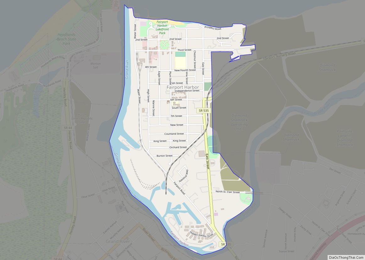
Fairport Harbor is a village in Lake County, Ohio, United States, along Lake Erie at the mouth of the Grand River. The population was 3,108 at the 2020 census. A suburb of Cleveland, it is part of the Cleveland metropolitan area. Fairport Harbor is home to two lighthouses: the Fairport Harbor West Breakwater Light in … Read more

Map of Fairlawn city

Map of Fairlawn city, Ohio

Fairlawn is a city in western Summit County, Ohio, United States, and a suburb of Akron. The population was 7,710 at the 2020 census. It is part of the Akron metropolitan area. Fairlawn city overview: Name: Fairlawn city LSAD Code: 25 LSAD Description: city (suffix) State: Ohio County: Summit County Elevation: 1,010 ft (308 m) Total Area: … Read more

Map of Fairfield city, Ohio

Map of Fairfield city, Ohio

Fairfield is a suburban city located in Butler county in the U.S. state of Ohio. Fairfield is located approximately 25 miles north of Cincinnati and is situated on the east bank of the Great Miami River. The population was 42,623 as of the 2020 Census. Incorporated in 1955 from portions of Fairfield Township, it includes … Read more

Map of Fletcher village, Ohio

Map of Fletcher village, Ohio

Fletcher is a village in Miami County, Ohio, United States. The population was 473 at the 2010 census. It is part of the Dayton Metropolitan Statistical Area. Fletcher village overview: Name: Fletcher village LSAD Code: 47 LSAD Description: village (suffix) State: Ohio County: Miami County Elevation: 1,043 ft (318 m) Total Area: 0.31 sq mi (0.80 km²) Land Area: 0.31 sq mi … Read more

Map of Flat Rock CDP, Ohio

Map of Flat Rock CDP, Ohio

Flat Rock is a census-designated place in northeastern Thompson Township, Seneca County, Ohio, United States. It has a post office with the ZIP code 44828. Flat Rock CDP overview: Name: Flat Rock CDP LSAD Code: 57 LSAD Description: CDP (suffix) State: Ohio County: Seneca County Total Area: 0.21 sq mi (0.55 km²) Land Area: 0.21 sq mi (0.55 km²) Water Area: … Read more

Map of Five Points CDP, Ohio

Map of Five Points CDP, Ohio

Five Points is a census-designated place (CDP) in Clearcreek Township, Warren County, Ohio, United States. The population was 2,247 at the 2020 census. Five Points was named for the five-way crossroads at the center of the original town site. Five Points CDP overview: Name: Five Points CDP LSAD Code: 57 LSAD Description: CDP (suffix) State: … Read more