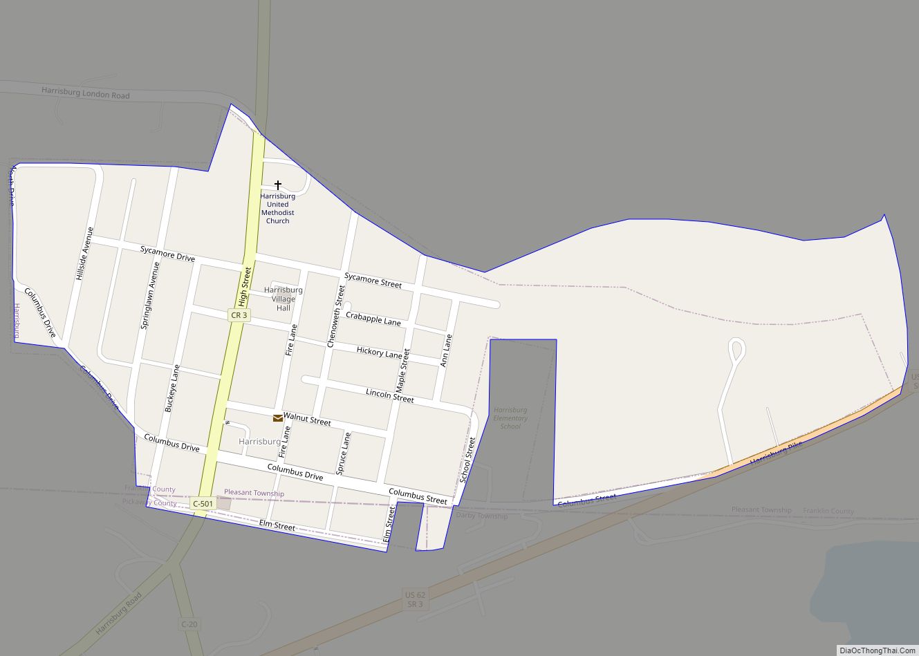
Map of Harrisville village, Ohio

Map of Harrisville village, Ohio

Harrisville is a village in Harrison County, Ohio, United States. The population was 179 at the 2020 census. Harrisville village overview: Name: Harrisville village LSAD Code: 47 LSAD Description: village (suffix) State: Ohio County: Harrison County Elevation: 1,250 ft (381 m) Total Area: 0.15 sq mi (0.39 km²) Land Area: 0.15 sq mi (0.39 km²) Water Area: 0.00 sq mi (0.00 km²) Total Population: 179 Population … Read more

Map of Hemlock village, Ohio

Map of Hemlock village, Ohio

Hemlock is a village in Perry County, Ohio, United States. The population was 142 at the 2020 census. The village was originally settled as Coaldale on June 15, 1869 and established as Hemlock on July 15, 1872. A post office was in operation until the early 2000s. Hemlock village overview: Name: Hemlock village LSAD Code: … Read more

Map of Helena village, Ohio

Map of Helena village, Ohio

Helena is a village in Sandusky County, Ohio, United States. The population was 224 at the 2010 census. Helena village overview: Name: Helena village LSAD Code: 47 LSAD Description: village (suffix) State: Ohio County: Sandusky County Elevation: 696 ft (212 m) Total Area: 0.29 sq mi (0.75 km²) Land Area: 0.29 sq mi (0.75 km²) Water Area: 0.00 sq mi (0.00 km²) Total Population: 211 Population … Read more

Map of Hebron village, Ohio

Map of Hebron village, Ohio

Hebron is a village in Licking County, Ohio, United States. The population was 2,336 at the 2010 census. Hebron village overview: Name: Hebron village LSAD Code: 47 LSAD Description: village (suffix) State: Ohio County: Licking County Elevation: 889 ft (271 m) Total Area: 2.96 sq mi (7.68 km²) Land Area: 2.96 sq mi (7.67 km²) Water Area: 0.00 sq mi (0.01 km²) Total Population: 2,326 Population … Read more

Map of Heath city, Ohio

Map of Heath city, Ohio

Heath is a city in Licking County, Ohio, United States, and is located approximately 30 mi (48 km) east of Columbus. The population was 10,310 at the 2010 census. It is one of three cities in the county. Heath city overview: Name: Heath city LSAD Code: 25 LSAD Description: city (suffix) State: Ohio County: Licking County Elevation: … Read more

Map of Hayesville village, Ohio

Map of Hayesville village, Ohio

Hayesville is a village in Vermillion Township, Ashland County, Ohio, United States. The population was 447 at the 2020 census. Hayesville village overview: Name: Hayesville village LSAD Code: 47 LSAD Description: village (suffix) State: Ohio County: Ashland County Elevation: 1,240 ft (378 m) Total Area: 0.74 sq mi (1.92 km²) Land Area: 0.74 sq mi (1.91 km²) Water Area: 0.00 sq mi (0.01 km²) Total Population: … Read more

Map of Haydenville CDP

Map of Haydenville CDP

Haydenville is an unincorporated community and census-designated place (CDP) in southern Green Township, Hocking County, Ohio, United States. As of the 2010 census the population of the CDP was 381. Haydenville CDP overview: Name: Haydenville CDP LSAD Code: 57 LSAD Description: CDP (suffix) State: Ohio County: Hocking County FIPS code: 3934594 Online Interactive Map Haydenville … Read more

Map of Haviland village, Ohio

Map of Haviland village, Ohio

Haviland is a village in Paulding County, Ohio, United States. The population was 215 at the 2010 census. Haviland village overview: Name: Haviland village LSAD Code: 47 LSAD Description: village (suffix) State: Ohio County: Paulding County Elevation: 735 ft (224 m) Total Area: 0.39 sq mi (1.02 km²) Land Area: 0.39 sq mi (1.02 km²) Water Area: 0.00 sq mi (0.00 km²) Total Population: 160 Population … Read more

Map of Haskins village

Map of Haskins village

Haskins is a village in Wood County, Ohio, United States. The population was 1,188 at the 2010 census. Haskins village overview: Name: Haskins village LSAD Code: 47 LSAD Description: village (suffix) State: Ohio County: Wood County Elevation: 656 ft (200 m) Total Area: 1.65 sq mi (4.26 km²) Land Area: 1.65 sq mi (4.26 km²) Water Area: 0.00 sq mi (0.00 km²) Total Population: 1,245 Population … Read more

Map of Harveysburg village

Map of Harveysburg village

Harveysburg is a village in Massie Township, Warren County, Ohio, United States. The population was 554 at the 2020 census. It is best known as the home of the Ohio Renaissance Festival. Harveysburg village overview: Name: Harveysburg village LSAD Code: 47 LSAD Description: village (suffix) State: Ohio County: Warren County Founded: 1829 Elevation: 928 ft (283 m) … Read more

Map of Hartville village, Ohio

Map of Hartville village, Ohio

Hartville is a village in Stark County, Ohio, United States. The population was 3,329 at the 2020 census. It is part of the Canton–Massillon metropolitan area. Hartville lies halfway between Akron and Canton, at the intersection of two main roads, State Routes 43 and 619. Hartville village overview: Name: Hartville village LSAD Code: 47 LSAD … Read more

Map of Hide-A-Way Hills CDP

Map of Hide-A-Way Hills CDP

Hide-A-Way Hills is a census-designated place (CDP) in Fairfield and Hocking counties in the U.S. state of Ohio. As of the 2010 census, the community had 688 residential units and a year-round population of 794. Hide-A-Way Hills CDP overview: Name: Hide-A-Way Hills CDP LSAD Code: 57 LSAD Description: CDP (suffix) State: Ohio County: Fairfield County, … Read more