Map of Highpoint CDP

Map of Highpoint CDP

Highpoint (also known as High Point) is an unincorporated community and census-designated place (CDP) in Sycamore Township, Hamilton County, Ohio, United States, located about 20 miles north of Cincinnati, Ohio. As of the 2020 census, its population was 1,558. Highpoint was founded in the 19th century. It was named Highpoint on account of its lofty … Read more

Map of Highland village, Ohio

Map of Highland village, Ohio

Highland is a village in Fairfield Township, Highland County, Ohio, United States. The population was 254 at the 2010 census. Highland village overview: Name: Highland village LSAD Code: 47 LSAD Description: village (suffix) State: Ohio County: Highland County Elevation: 1,063 ft (324 m) Total Area: 0.17 sq mi (0.44 km²) Land Area: 0.17 sq mi (0.44 km²) Water Area: 0.00 sq mi (0.00 km²) Total Population: … Read more

Map of Highland Holiday CDP

Map of Highland Holiday CDP

Highland Holiday is an unincorporated community and census-designated place in Highland County, Ohio, United States. Its population was 550 as of the 2010 census. Highland Holiday CDP overview: Name: Highland Holiday CDP LSAD Code: 57 LSAD Description: CDP (suffix) State: Ohio County: Highland County Elevation: 938 ft (286 m) Total Area: 1.10 sq mi (2.84 km²) Land Area: 0.60 sq mi (1.56 km²) … Read more

Map of Highland Hills village

Map of Highland Hills village

Highland Hills is a village in Cuyahoga County, Ohio, United States. The population was 662 at the 2020 census. It was formally incorporated in 1990. Highland Hills village overview: Name: Highland Hills village LSAD Code: 47 LSAD Description: village (suffix) State: Ohio County: Cuyahoga County Elevation: 1,096 ft (334 m) Total Area: 1.96 sq mi (5.09 km²) Land Area: 1.96 sq mi … Read more

Map of Highland Heights city, Ohio

Map of Highland Heights city, Ohio

Highland Heights is a city in Cuyahoga County, Ohio, United States. A suburb of Cleveland, Highland Heights is part of the Cleveland metropolitan area. As of the 2020 census, the city’s population was 8,719. Highland Heights city overview: Name: Highland Heights city LSAD Code: 25 LSAD Description: city (suffix) State: Ohio County: Cuyahoga County Founded: … Read more

Map of Higginsport village

Map of Higginsport village

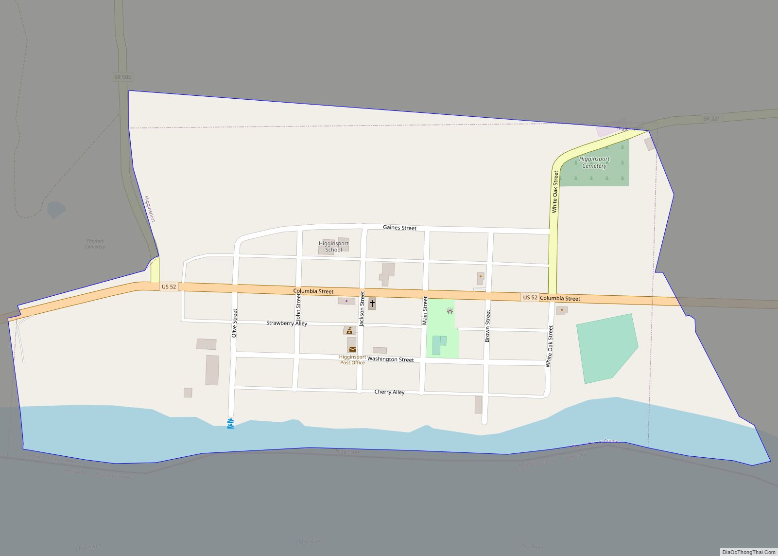
Higginsport is a village in Lewis Township, Brown County, Ohio, United States, along the Ohio River. The population was 251 at the 2010 census. Higginsport village overview: Name: Higginsport village LSAD Code: 47 LSAD Description: village (suffix) State: Ohio County: Brown County Elevation: 512 ft (156 m) Total Area: 0.29 sq mi (0.76 km²) Land Area: 0.25 sq mi (0.65 km²) Water Area: … Read more

Map of Hide-A-Way Hills CDP

Map of Hide-A-Way Hills CDP

Hide-A-Way Hills is a census-designated place (CDP) in Fairfield and Hocking counties in the U.S. state of Ohio. As of the 2010 census, the community had 688 residential units and a year-round population of 794. Hide-A-Way Hills CDP overview: Name: Hide-A-Way Hills CDP LSAD Code: 57 LSAD Description: CDP (suffix) State: Ohio County: Fairfield County, … Read more

Map of Hicksville village, Ohio

Map of Hicksville village, Ohio

Hicksville is a village in Defiance County, Ohio, United States. The population was 3,581 at the 2010 census. It sits around 2.2 miles east from the Ohio- Indiana border. Hicksville village overview: Name: Hicksville village LSAD Code: 47 LSAD Description: village (suffix) State: Ohio County: Defiance County Elevation: 761 ft (232 m) Total Area: 2.55 sq mi (6.61 km²) Land … Read more

Map of Hessville CDP

Map of Hessville CDP

Hessville is an unincorporated community and census-designated places in Washington Township, Sandusky County, Ohio, United States. Hessville CDP overview: Name: Hessville CDP LSAD Code: 57 LSAD Description: CDP (suffix) State: Ohio County: Sandusky County FIPS code: 3935028 Online Interactive Map Hessville online map. Source: Basemap layers from Google Map, Open Street Map (OSM), Arcgisonline, Wmflabs. … Read more

Map of Hockingport CDP

Map of Hockingport CDP

Hockingport is a census-designated place in southeastern Troy Township, Athens County, Ohio, United States. As of the 2020 census it had a population of 205. It has a post office with the ZIP code 45739. It is located at the intersection of State Routes 124 and 144. It lies on the Ohio River, located below … Read more

Map of Hiram village, Ohio

Map of Hiram village, Ohio

Hiram is a village in northern Portage County, Ohio, United States. It was formed from portions of Hiram Township in the Connecticut Western Reserve. The population was 996 at the 2020 census. Hiram is part of the Akron metropolitan area. It is the home of Hiram College, a small, private liberal arts college. Hiram village … Read more

Map of Hilltop CDP, Ohio

Map of Hilltop CDP, Ohio

Hilltop is an unincorporated community and census-designated place in central Weathersfield Township, Trumbull County, Ohio, United States. The population was 658 at the 2020 census. It is part of the Youngstown–Warren metropolitan area. Hilltop CDP overview: Name: Hilltop CDP LSAD Code: 57 LSAD Description: CDP (suffix) State: Ohio County: Trumbull County Elevation: 978 ft (298 m) Total … Read more