Map of Logan city, Ohio
Logan is a city in and county seat of Hocking County, Ohio, United States, along the on the Hocking River about 43 miles (69 km) southeast of Columbus. The population was 7,296 at the time of the 2020 census. The current mayor of Logan is Republican Greg Fraunfelter, who began a four-year term in January 2016 ... Read more
Map of Logan city, Ohio
Map of Logan Elm Village CDP
Logan Elm Village is a census-designated place (CDP) in Pickaway County, Ohio, United States, near the site of the Logan Elm. The population was 1,062 at the 2000 census. “Logan elm” originally referred to a large individual elm tree where Logan the Orator gave a speech. Logan Elm Village CDP overview: Name: Logan Elm Village ... Read more
Map of Logan Elm Village CDP
Map of Lodi village, Ohio
Lodi is a village in Harrisville Township, Medina County, Ohio, United States. It is located southwest of the City of Medina along U.S. Route 42. As of the 2010 census, the population was 2,746. Lodi village overview: Name: Lodi village LSAD Code: 47 LSAD Description: village (suffix) State: Ohio County: Medina County Founded: 1811; 212 years ... Read more
Map of Lodi village, Ohio
Map of Lockland village
Lockland is a village in Hamilton County, Ohio, United States. The population was 3,514 at the 2020 United States Census. Lockland is located in southwest Ohio, north of Cincinnati. Its population has declined since the latter part of the 20th century. Lockland village overview: Name: Lockland village LSAD Code: 47 LSAD Description: village (suffix) State: ... Read more
Map of Lockland village
Map of Lockington village
Lockington (originally called Locksport) is a village in Washington Township, Shelby County, Ohio, United States, along Loramie Creek. The population was 141 at the 2010 census. Lockington village overview: Name: Lockington village LSAD Code: 47 LSAD Description: village (suffix) State: Ohio County: Shelby County Elevation: 948 ft (289 m) Total Area: 0.08 sq mi (0.22 km²) Land Area: 0.08 sq mi (0.22 km²) ... Read more
Map of Lockington village
Map of Lockbourne village
Lockbourne is a village in Franklin County and Pickaway County, Ohio, United States. The population was 236 at the 2020 census. Lockbourne is located near Rickenbacker International Airport, and had initially provided its original name of Lockbourne Air Force Base. Lockbourne village overview: Name: Lockbourne village LSAD Code: 47 LSAD Description: village (suffix) State: Ohio ... Read more
Map of Lockbourne village
Map of Little Hocking CDP
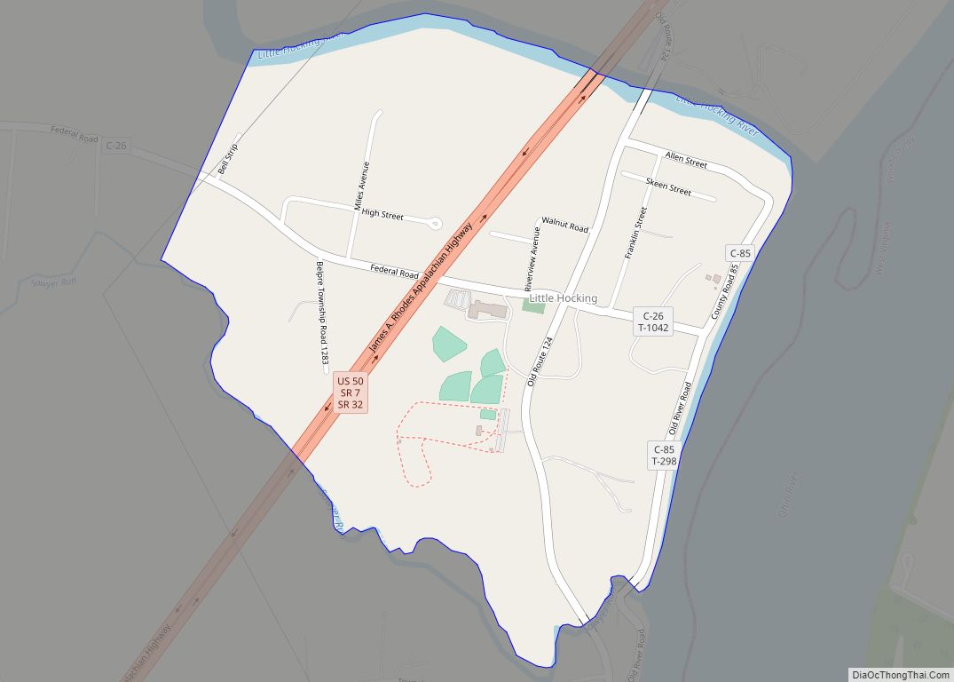
Little Hocking is a census-designated place in southern Belpre Township, Washington County, Ohio, United States. It has a post office with the ZIP code 45742. Little Hocking lies along the Ohio River a few miles below the county seat of Marietta. It sits at the intersection of U.S. Route 50 with State Route 124 and ... Read more
Map of Little Hocking CDP
Map of Lithopolis village
Lithopolis is a village in Fairfield and Franklin counties in the U.S. state of Ohio. The population was 2,134 at the 2020 census. Lithopolis village overview: Name: Lithopolis village LSAD Code: 47 LSAD Description: village (suffix) State: Ohio County: Fairfield County, Franklin County Elevation: 945 ft (288 m) Total Area: 2.27 sq mi (5.88 km²) Land Area: 2.27 sq mi (5.87 km²) Water ... Read more
Map of Lithopolis village
Map of Lisbon village, Ohio
Lisbon is a village in and the county seat of Columbiana County, Ohio, United States, along the Little Beaver Creek. The population was 2,597 at the 2020 census. It is a part of the Salem micropolitan area, about 23 miles (37 km) southwest of Youngstown. Lisbon village overview: Name: Lisbon village LSAD Code: 47 LSAD Description: ... Read more
Map of Lisbon village, Ohio
Map of Lore City village
Lore City is a village in Guernsey County, Ohio, United States. The population was 325 at the 2010 census. Lore City village overview: Name: Lore City village LSAD Code: 47 LSAD Description: village (suffix) State: Ohio County: Guernsey County Elevation: 820 ft (250 m) Total Area: 0.33 sq mi (0.85 km²) Land Area: 0.33 sq mi (0.85 km²) Water Area: 0.00 sq mi (0.00 km²) Total ... Read more
Map of Lore City village
Map of Lordstown village
Lordstown is a village in southern Trumbull County, Ohio, United States. The population was 3,332 at the 2020 census. It is part of the Youngstown–Warren metropolitan area. Lordstown is best known as the home of the Lordstown Assembly, a General Motors automotive plant that produced compact cars from 1966 until 2019. After the closure of ... Read more
Map of Lordstown village
Map of Lorain city, Ohio
Lorain (/lɔːˈreɪn/) is a city in Lorain County, Ohio, United States. It is located in Northeast Ohio on Lake Erie at the mouth of the Black River, about 25 miles (40 km) miles west of Cleveland. As of the 2020 census, the city had a population of 65,211, making it Ohio’s ninth-largest city, the third-largest in ... Read more
Map of Lorain city, Ohio