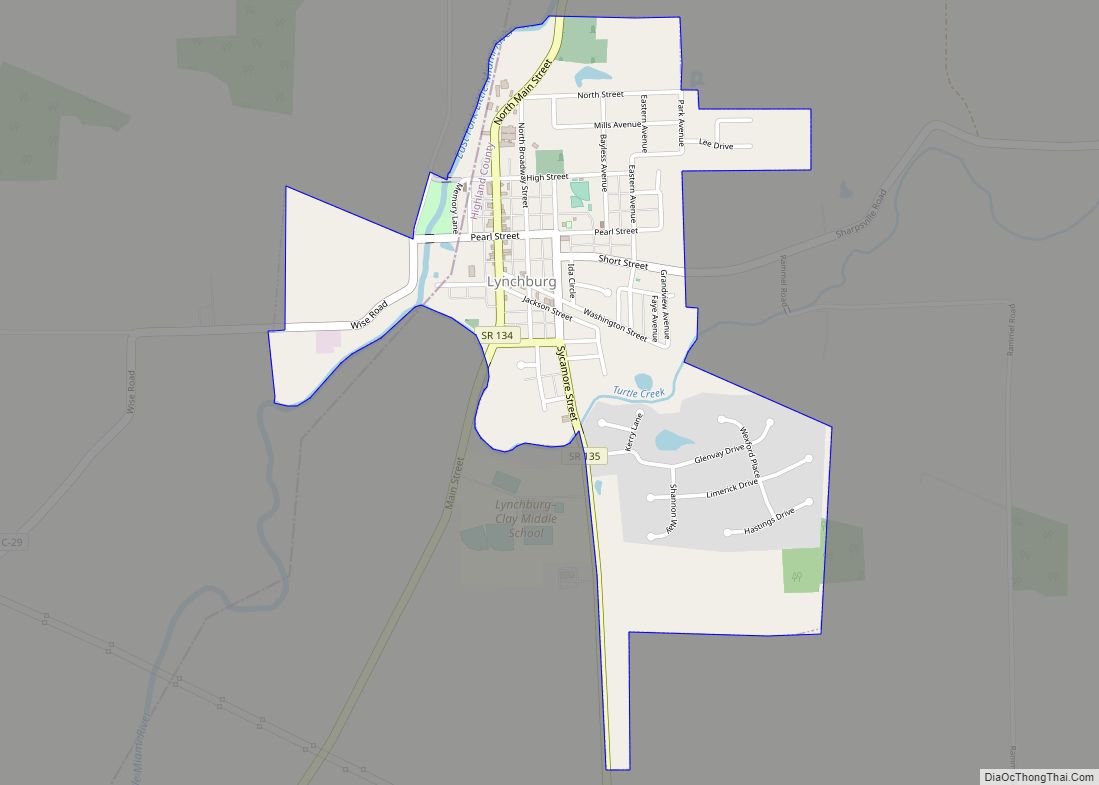
Ludlow Falls is a village in Miami County, Ohio, United States. The population was 208 at the 2010 census. It is part of the Dayton Metropolitan Statistical Area. Ludlow Falls is named after surveyor Israel Ludlow. Ludlow Falls village overview: Name: Ludlow Falls village LSAD Code: 47 LSAD Description: village (suffix) State: Ohio County: Miami ... Read more
Ohio Cities and Places
Luckey is a village in Wood County, Ohio, United States. The population was 1,012 at the 2010 census. Luckey village overview: Name: Luckey village LSAD Code: 47 LSAD Description: village (suffix) State: Ohio County: Wood County Elevation: 666 ft (203 m) Total Area: 0.69 sq mi (1.79 km²) Land Area: 0.69 sq mi (1.79 km²) Water Area: 0.00 sq mi (0.00 km²) Total Population: 1,009 Population ... Read more
Lucasville is a census-designated place (CDP) in Scioto County, Ohio, United States. The population was 1,655 at the 2020 census. It is part of the Portsmouth micropolitan area. Lucasville is the location of the Scioto County Fairgrounds. The Southern Ohio Correctional Facility, Ohio’s one of three maximum security prisons and the location of Ohio’s death ... Read more
Lucas is a village in southeastern Richland County, Ohio, United States. Lucas is part of the Mansfield, Ohio Metropolitan Statistical Area. Lucas village overview: Name: Lucas village LSAD Code: 47 LSAD Description: village (suffix) State: Ohio County: Richland County Elevation: 1,093 ft (333 m) Total Area: 0.68 sq mi (1.76 km²) Land Area: 0.68 sq mi (1.75 km²) Water Area: 0.00 sq mi (0.00 km²) Total ... Read more
Macksburg is a village in Washington County, Ohio, United States, along the West Fork of Duck Creek. The population was 120 at the 2020 census. The village is about 28 miles (45 km) south of Cambridge, Ohio. Macksburg village overview: Name: Macksburg village LSAD Code: 47 LSAD Description: village (suffix) State: Ohio County: Washington County Elevation: ... Read more
Mansfield is a city in and the county seat of Richland County, Ohio, United States. Located midway between Columbus and Cleveland via Interstate 71, it is part of Northeast Ohio region in the western foothills of the Allegheny Plateau. The city lies approximately 65 miles (105 km) southwest of Cleveland, 45 miles (72 km) southwest of Akron ... Read more
Manchester is a village in Manchester Township, Adams County, Ohio, United States, along the Ohio River. The population was 1,839 at the 2020 census. Manchester village overview: Name: Manchester village LSAD Code: 47 LSAD Description: village (suffix) State: Ohio County: Adams County Elevation: 505 ft (154 m) Total Area: 1.29 sq mi (3.33 km²) Land Area: 1.27 sq mi (3.28 km²) Water Area: ... Read more
Malvern is a village in northwestern Carroll County, Ohio, United States. The population was 1,110 at the 2020 census. It is part of the Canton–Massillon metropolitan area. Malvern village overview: Name: Malvern village LSAD Code: 47 LSAD Description: village (suffix) State: Ohio County: Carroll County Elevation: 994 ft (303 m) Total Area: 0.73 sq mi (1.89 km²) Land Area: 0.73 sq mi ... Read more
Malta is a village in Morgan County, Ohio, United States. The population was 559 at the 2020 census. Malta village overview: Name: Malta village LSAD Code: 47 LSAD Description: village (suffix) State: Ohio County: Morgan County Elevation: 676 ft (206 m) Total Area: 0.39 sq mi (1.00 km²) Land Area: 0.34 sq mi (0.89 km²) Water Area: 0.04 sq mi (0.11 km²) Total Population: 559 Population ... Read more
Malinta is a village in Henry County, Ohio, United States. The population was 265 at the 2010 census, a decrease of 7.0% from the 2000 census. Malinta village overview: Name: Malinta village LSAD Code: 47 LSAD Description: village (suffix) State: Ohio County: Henry County Elevation: 686 ft (209 m) Total Area: 0.77 sq mi (1.99 km²) Land Area: 0.77 sq mi (1.99 km²) ... Read more
Maineville is a village in Warren County, Ohio, United States. The population was 1,405 at the 2020 census. Maineville village overview: Name: Maineville village LSAD Code: 47 LSAD Description: village (suffix) State: Ohio County: Warren County Elevation: 810 ft (247 m) Total Area: 1.59 sq mi (4.11 km²) Land Area: 1.59 sq mi (4.11 km²) Water Area: 0.00 sq mi (0.00 km²) Total Population: 1,405 Population ... Read more
Magnolia is a village in Carroll and Stark counties in the U.S. state of Ohio. The population was 1,013 at the time of the 2020 census. It is part of the Canton–Massillon metropolitan area. Magnolia village overview: Name: Magnolia village LSAD Code: 47 LSAD Description: village (suffix) State: Ohio County: Carroll County, Stark County Elevation: ... Read more