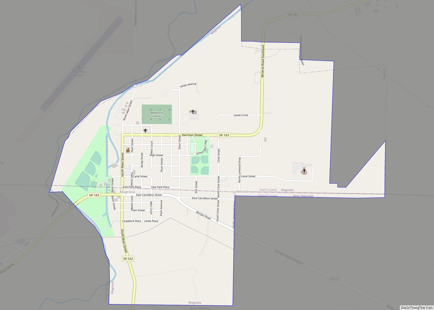
Map of Magnetic Springs village

Map of Magnetic Springs village

Magnetic Springs is a village in Leesburg Township, Union County, Ohio, United States. The population was 268 at the 2010 census. The village supports a post office that has the ZIP Code of 43036. Magnetic Springs village overview: Name: Magnetic Springs village LSAD Code: 47 LSAD Description: village (suffix) State: Ohio County: Union County Elevation: … Read more

Map of Madison village, Ohio

Map of Madison village, Ohio

Madison is a village in Lake County, Ohio, United States. The population was 3,184 at the 2010 census. Madison was incorporated as a village in 1867. Madison village overview: Name: Madison village LSAD Code: 47 LSAD Description: village (suffix) State: Ohio County: Lake County Elevation: 728 ft (222 m) Total Area: 5.09 sq mi (13.17 km²) Land Area: 5.09 sq mi (13.17 km²) … Read more

Map of Madeira city

Map of Madeira city

Madeira is a city in Hamilton County, Ohio, United States. The population was 9,487 at the 2020 census. Madeira has a Council-Manager form of government, where the elected City Council appoints a paid City Manager to run the day-to-day operations of the city. Madeira is served by its own police department, while fire service is … Read more

Map of Marblehead village, Ohio

Map of Marblehead village, Ohio

Marblehead is a village in Ottawa County, Ohio, United States. The population was 865 at the 2020 census. It sits at the tip of the Marblehead Peninsula, which divides Lake Erie proper from Sandusky Bay.Marblehead is part of the area that is referred to regionally as Vacationland (which includes nearby Sandusky and the Lake Erie … Read more

Map of Marble Cliff village

Map of Marble Cliff village

Marble Cliff is a village in Franklin County, Ohio, United States. The population was 634 at the 2020 census. Marble Cliff was one of the first suburbs of Columbus, Ohio, settled as a community in 1890 and incorporated as the “Hamlet of Marble Cliff” in 1901. It took its name from the Marble Cliff Quarry … Read more

Map of Maplewood Park CDP

Map of Maplewood Park CDP

Maplewood Park is an unincorporated community and census-designated place in southern Hubbard Township, Trumbull County, Ohio, United States. The population was 243 at the 2020 census. It is part of the Youngstown–Warren metropolitan area. Maplewood Park CDP overview: Name: Maplewood Park CDP LSAD Code: 57 LSAD Description: CDP (suffix) State: Ohio County: Trumbull County Elevation: … Read more

Map of Maple Ridge CDP

Map of Maple Ridge CDP

Maple Ridge is a census-designated place in southwestern Mahoning County, Ohio, United States, located between Alliance and Sebring. The population was 667 at the 2020 census. It is part of the Youngstown–Warren metropolitan area. Maple Ridge CDP overview: Name: Maple Ridge CDP LSAD Code: 57 LSAD Description: CDP (suffix) State: Ohio County: Mahoning County Elevation: … Read more

Map of Maple Heights city

Map of Maple Heights city

Maple Heights is a city in Cuyahoga County, Ohio, United States. It is a suburb of Cleveland. The population was 23,701 at the 2020 census. Maple Heights city overview: Name: Maple Heights city LSAD Code: 25 LSAD Description: city (suffix) State: Ohio County: Cuyahoga County Elevation: 896 ft (273 m) Total Area: 5.17 sq mi (13.39 km²) Land Area: 5.17 sq mi … Read more

Map of Mantua village

Map of Mantua village, Ohio

Mantua (/ˈmænəweɪ/ MAN-ə-way) is a village in northern Portage County, Ohio, United States, along the Cuyahoga River. The population was 1,001 at the time of the 2020 census. It is part of the Akron metropolitan area. It was formed from portions of Mantua Township in the Connecticut Western Reserve. Mantua village overview: Name: Mantua village … Read more

Map of Marion city, Ohio

Map of Marion city, Ohio

Marion is a city in and the county seat of Marion County, Ohio, United States. It is located in north-central Ohio, approximately 50 miles (80 km) north of Columbus. The population was 35,999 at the 2020 census, slightly down from 36,837 at the 2010 census. It is the largest city in Marion County and the principal … Read more

Map of Marietta city, Ohio

Map of Marietta city, Ohio

Marietta is a city in, and the county seat of, Washington County, Ohio, United States. It is located in southeastern Ohio at the confluence of the Muskingum and Ohio Rivers, 11 miles (18 km) northeast of Parkersburg, West Virginia. As of the 2020 census, Marietta has a population of 13,385 people. It is the principal city … Read more

Map of Mariemont village

Map of Mariemont village

Mariemont (pronounced /ˈmɛərimɒnt/ MAIR-ee-mont) is a village in Hamilton County, Ohio, United States. It includes two overlapping historic districts, Village of Mariemont and Mariemont Historic District. Named for its founder, Mary Emery, Mariemont exhibits English architecture from Norman to classic Georgian style. Several parks exist in the village, including the Concourse on Miami Bluff Drive, … Read more