Map of North Bend village, Ohio

Map of North Bend village, Ohio

North Bend is a village in Miami Township, Hamilton County, Ohio, United States, along the Ohio River. It is a part of the Greater Cincinnati area. The population was 835 at the 2020 census. North Bend village overview: Name: North Bend village LSAD Code: 47 LSAD Description: village (suffix) State: Ohio County: Hamilton County Elevation: … Read more

Map of North Baltimore village

Map of North Baltimore village

North Baltimore is a village in Wood County, Ohio, United States and is part of the Toledo, OH Metropolitan Statistical Area. The population was 3,432 at the 2010 census. The village is a member of the Toledo Metropolitan Area Council of Governments. North Baltimore village overview: Name: North Baltimore village LSAD Code: 47 LSAD Description: … Read more

Map of Niles city, Ohio

Map of Niles city, Ohio

Niles is a city in southern Trumbull County, Ohio, United States, situated at the confluence of the Mahoning River and Mosquito Creek. The city’s population was 18,443 at the 2020 census. It is a suburb of the Youngstown–Warren metropolitan area. Located in the nation’s former industrial belt, the city’s economy focused initially on iron manufacturing … Read more

Map of Ney village

Map of Ney village

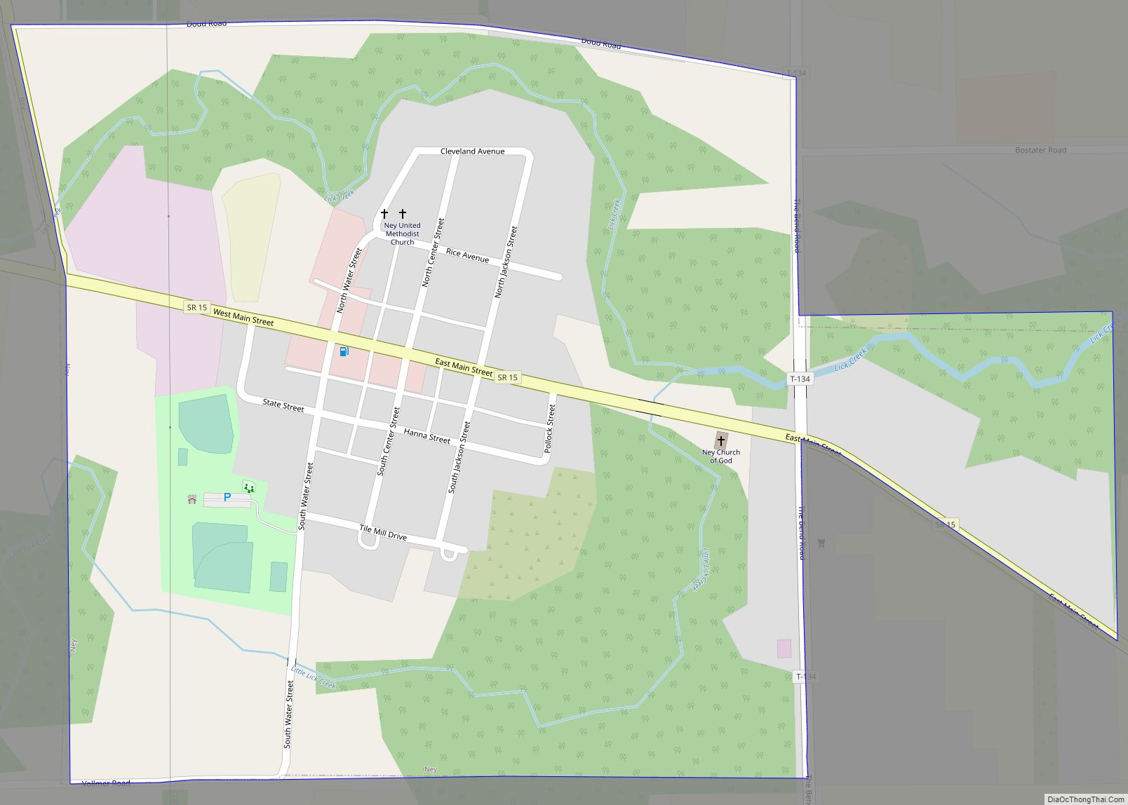
Ney is a village in Defiance County, Ohio, United States. The population was 354 at the 2010 census. Ney has been noted for having one of the shortest place names in Ohio. Ney village overview: Name: Ney village LSAD Code: 47 LSAD Description: village (suffix) State: Ohio County: Defiance County Elevation: 709 ft (216 m) Total Area: … Read more

Map of Newtown village, Ohio

Map of Newtown village, Ohio

Newtown is a village in southeastern Hamilton County, Ohio, United States, near Cincinnati. The population was 2,702 at the 2020 census. Newtown was settled in 1792 and incorporated as a village in 1901. Newtown village overview: Name: Newtown village LSAD Code: 47 LSAD Description: village (suffix) State: Ohio County: Hamilton County Elevation: 499 ft (152 m) Total … Read more

Map of North Perry village

Map of North Perry village

North Perry is a village in Lake County, Ohio, United States. The population was 893 at the 2010 census. North Perry village overview: Name: North Perry village LSAD Code: 47 LSAD Description: village (suffix) State: Ohio County: Lake County Elevation: 682 ft (208 m) Total Area: 3.88 sq mi (10.05 km²) Land Area: 3.88 sq mi (10.05 km²) Water Area: 0.00 sq mi (0.00 km²) Total … Read more

Map of North Olmsted city

Map of North Olmsted city

North Olmsted is a city in Cuyahoga County, Ohio, United States. As of the 2020 census, the city population was 32,442. North Olmsted is a west side suburb of Cleveland, Ohio, and is the 8th most populated city within Cuyahoga County. North Olmsted city overview: Name: North Olmsted city LSAD Code: 25 LSAD Description: city … Read more

Map of North Madison CDP

Map of North Madison CDP

North Madison is a census-designated place (CDP) comprising the unincorporated communities of Redbird and Madison-on-the-Lake in Lake County, Ohio, United States. The population was 8,547 at the 2010 census. The CDP is located 1 mile (1.6 km) north of the unincorporated community of North Madison and U.S. Route 20. The area uses a mailing address of … Read more

Map of North Lewisburg village

Map of North Lewisburg village

North Lewisburg is a village in Champaign County, Ohio The population was 1,490 at the time of the 2010 census. North Lewisburg village overview: Name: North Lewisburg village LSAD Code: 47 LSAD Description: village (suffix) State: Ohio County: Champaign County Elevation: 1,093 ft (333 m) Total Area: 1.09 sq mi (2.81 km²) Land Area: 1.09 sq mi (2.81 km²) Water Area: 0.00 sq mi (0.00 km²) … Read more

Map of North Lawrence CDP

Map of North Lawrence CDP

North Lawrence is a census-designated place in southwestern Lawrence Township, Stark County, Ohio, United States. It has a post office with the ZIP code 44666. The community is part of the Canton–Massillon Metropolitan Statistical Area. North Lawrence is also the site of the water resort Clay’s Park. Its main road is Ohio State Route 93, … Read more

Map of North Star village, Ohio

Map of North Star village, Ohio

North Star is a village in Darke County, Ohio, United States. The population was 236 at the 2010 census. North Star village overview: Name: North Star village LSAD Code: 47 LSAD Description: village (suffix) State: Ohio County: Darke County Elevation: 1,004 ft (306 m) Total Area: 0.51 sq mi (1.33 km²) Land Area: 0.51 sq mi (1.33 km²) Water Area: 0.00 sq mi (0.00 km²) Total … Read more

Map of North Royalton city

Map of North Royalton city

North Royalton is a city in Cuyahoga County, Ohio, United States. It is a suburb of Cleveland. The population was 31,322 as of the 2020 Census. Originally incorporated as a village in 1927, it achieved the status of city in 1961. North Royalton city overview: Name: North Royalton city LSAD Code: 25 LSAD Description: city … Read more