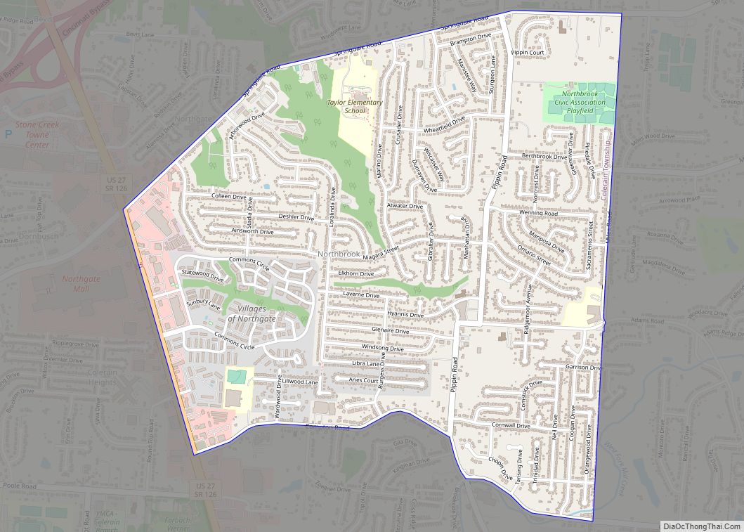
Map of Northfield village, Ohio

Map of Northfield village, Ohio

Northfield is a village in northern Summit County, Ohio, United States. The population was 3,541 at the 2020 census. It is part of the Akron metropolitan area. Northfield village overview: Name: Northfield village LSAD Code: 47 LSAD Description: village (suffix) State: Ohio County: Summit County Elevation: 1,050 ft (320 m) Total Area: 1.05 sq mi (2.72 km²) Land Area: 1.05 sq mi … Read more

Map of Ohio City village

Map of Ohio City village

Ohio City is a village in Liberty Township, Van Wert County, Ohio, United States. The population was 705 at the 2010 census. It is included within the Van Wert, Ohio Micropolitan Statistical Area. Ohio City village overview: Name: Ohio City village LSAD Code: 47 LSAD Description: village (suffix) State: Ohio County: Van Wert County Elevation: … Read more

Map of Octa village

Map of Octa village

Octa is a village in Fayette County, Ohio, United States, along Rattlesnake Creek. The population was 59 at the 2010 census. Octa village overview: Name: Octa village LSAD Code: 47 LSAD Description: village (suffix) State: Ohio County: Fayette County Elevation: 1,043 ft (318 m) Total Area: 0.29 sq mi (0.75 km²) Land Area: 0.29 sq mi (0.75 km²) Water Area: 0.00 sq mi (0.00 km²) Total … Read more

Map of Oceola CDP

Map of Oceola CDP

Oceola is a census-designated place (CDP) in central Tod Township, Crawford County, Ohio, United States. As of the 2010 census its population was 190. It has a post office with the ZIP code 44860. It is located along the road that was U.S. Route 30 until being upgraded to a freeway. Oceola CDP overview: Name: … Read more

Map of Obetz village

Map of Obetz village

Obetz is a village in Franklin County, Ohio, United States. The population was 5,489 at the 2020 census. Obetz village overview: Name: Obetz village LSAD Code: 47 LSAD Description: village (suffix) State: Ohio County: Franklin County Elevation: 800 ft (228 m) Total Area: 5.97 sq mi (15.47 km²) Land Area: 5.83 sq mi (15.09 km²) Water Area: 0.15 sq mi (0.39 km²) Total Population: 5,489 Population … Read more

Map of Oberlin city, Ohio

Map of Oberlin city, Ohio

Oberlin is a city in Lorain County, Ohio, United States. It is located about 31 miles (50 km) southwest of Cleveland within the Cleveland metropolitan area. The population was 8,555 at the 2020 census. Oberlin is the home of Oberlin College, a liberal arts college and music conservatory with approximately 3,000 students. The town is the … Read more

Map of Oakwood village, Ohio

Map of Oakwood village, Ohio

Oakwood is a village in Cuyahoga County, Ohio, United States. The population was 3,667 at the 2010 census. It is an inner ring suburb of Cleveland. Oakwood village overview: Name: Oakwood village LSAD Code: 47 LSAD Description: village (suffix) State: Ohio County: Cuyahoga County Elevation: 1,047 ft (319 m) Total Area: 3.46 sq mi (8.95 km²) Land Area: 3.45 sq mi (8.93 km²) … Read more

Map of Oak Hill village, Ohio

Map of Oak Hill village, Ohio

Oak Hill is a village in Jackson County, Ohio, United States. The population was 1,551 at the 2010 census. Oak Hill village overview: Name: Oak Hill village LSAD Code: 47 LSAD Description: village (suffix) State: Ohio County: Jackson County Elevation: 699 ft (213 m) Total Area: 1.27 sq mi (3.29 km²) Land Area: 1.27 sq mi (3.29 km²) Water Area: 0.00 sq mi (0.00 km²) Total … Read more

Map of Oak Harbor village

Map of Oak Harbor village, Ohio

Oak Harbor is a village in Ottawa County, Ohio, United States. Oak Harbor is 30 miles east of Downtown Toledo. The population was 2,759 at the 2010 census. It lies a short distance southwest of the Davis-Besse Nuclear Power Station, one of two nuclear power plants in Ohio. Oak Harbor village overview: Name: Oak Harbor … Read more

Map of Old Washington village

Map of Old Washington village

Old Washington is a village in Guernsey County, Ohio, United States. The population was 279 at the 2010 census. Old Washington village overview: Name: Old Washington village LSAD Code: 47 LSAD Description: village (suffix) State: Ohio County: Guernsey County Elevation: 1,014 ft (309 m) Total Area: 0.67 sq mi (1.74 km²) Land Area: 0.67 sq mi (1.74 km²) Water Area: 0.00 sq mi (0.00 km²) Total … Read more

Map of Old Fort CDP, Ohio

Map of Old Fort CDP, Ohio

Old Fort is a census-designated place located in northern Pleasant Township, Seneca County, Ohio, United States; located about a mile east of Ohio State Route 53 where N. Township Rd. 73 intersects with E. County Rd. 51. The ZIP code is 44861. Old Fort was platted in 1882, and named after Fort Seneca, a fort … Read more

Map of Osgood village, Ohio

Map of Osgood village, Ohio

Osgood is a village in Darke County, Ohio, United States. The population was 302 at the 2010 census. Osgood village overview: Name: Osgood village LSAD Code: 47 LSAD Description: village (suffix) State: Ohio County: Darke County Elevation: 961 ft (293 m) Total Area: 0.35 sq mi (0.91 km²) Land Area: 0.35 sq mi (0.91 km²) Water Area: 0.00 sq mi (0.00 km²) Total Population: 306 Population … Read more