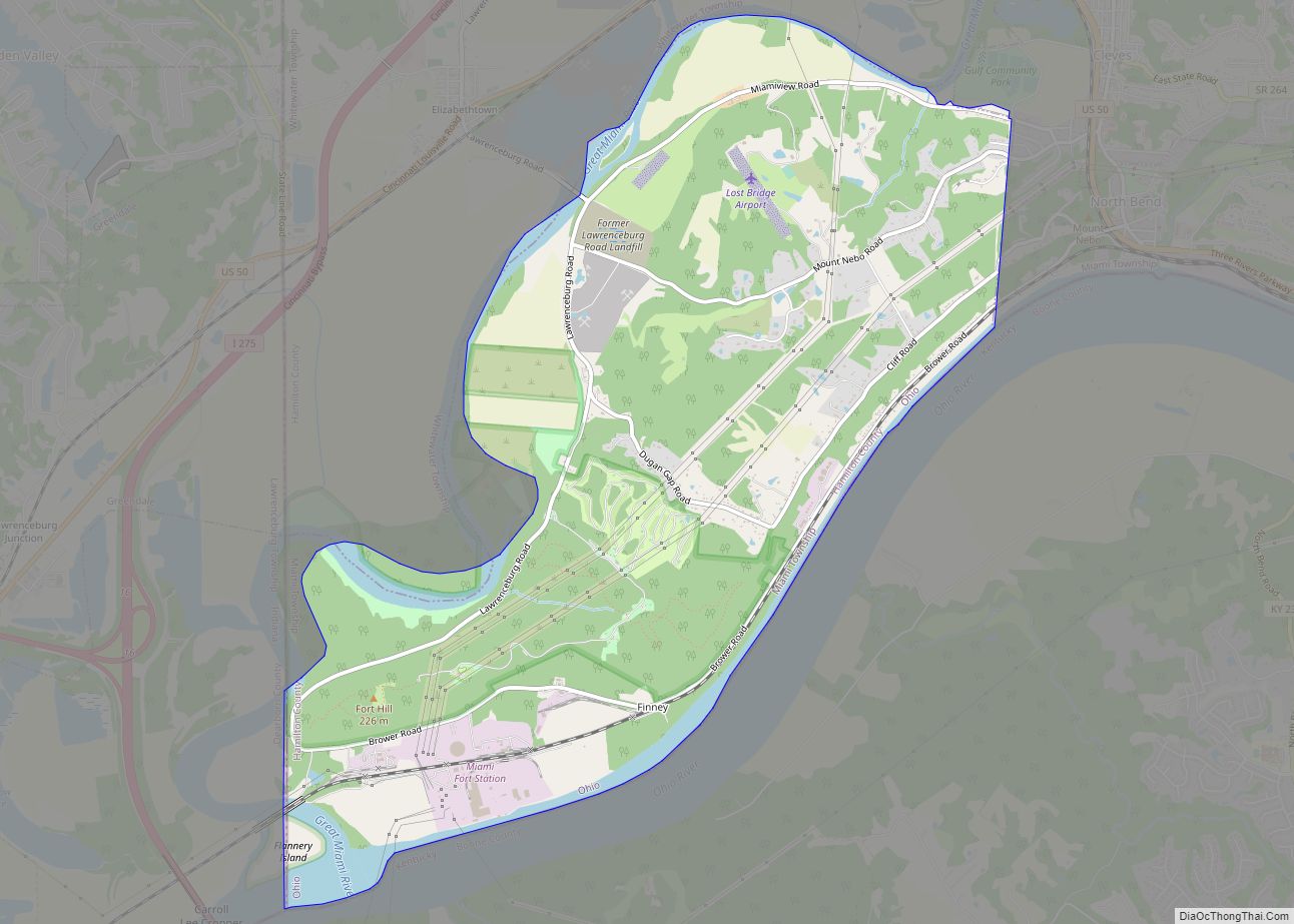
Map of Shreve village

Map of Shreve village

Shreve is a village in Clinton Township, Wayne County, Ohio, United States. The population was 1,514 at the 2010 census. Shreve is served by a branch of the Wayne County Public Library. Shreve village overview: Name: Shreve village LSAD Code: 47 LSAD Description: village (suffix) State: Ohio County: Wayne County Elevation: 902 ft (275 m) Total Area: … Read more

Map of South Amherst village, Ohio

Map of South Amherst village, Ohio

South Amherst is a village in Lorain County, Ohio, United States. The population was 1,581 at the 2020 census. South Amherst village overview: Name: South Amherst village LSAD Code: 47 LSAD Description: village (suffix) State: Ohio County: Lorain County Elevation: 794 ft (242 m) Total Area: 2.43 sq mi (6.28 km²) Land Area: 2.41 sq mi (6.23 km²) Water Area: 0.02 sq mi (0.05 km²) Total … Read more

Map of Somerville CDP, Ohio

Map of Somerville CDP, Ohio

Somerville is a census-designated place (CDP) and former village in Milford Township, Butler County, Ohio, United States. The population was 281 at the 2010 census. Somerville CDP overview: Name: Somerville CDP LSAD Code: 57 LSAD Description: CDP (suffix) State: Ohio County: Butler County Incorporated: 1832 Elevation: 771 ft (235 m) Total Area: 0.27 sq mi (0.69 km²) Land Area: 0.26 sq mi … Read more

Map of Somerset village, Ohio

Map of Somerset village, Ohio

Somerset is a village in Perry County, Ohio, United States. The population was 1,481 at the 2020 census. It is located 9.5 miles (15.3 km) north of the county seat New Lexington and has a dedicated historical district. Saint Joseph Church, the oldest Catholic church in Ohio, is located just outside Somerset on State Route 383. … Read more

Map of Solon city, Ohio

Map of Solon city, Ohio

Solon (/ˈsoʊlən/ SOH-lun) is a city in southeastern Cuyahoga County, Ohio, United States. A suburb of Cleveland, it is part of the Cleveland metropolitan area. According to the 2020 census, the population of Solon was 24,262. The city has been recognized by Money in its list of “Best Places to Live”, placing 23rd in 2009, … Read more

Map of Smithville village, Ohio

Map of Smithville village, Ohio

Smithville is a village in Wayne County, Ohio, United States. The population was 1,252 at the time of the 2010 census. The village derives its name from Thomas Smith, a pioneer settler. Smithville village overview: Name: Smithville village LSAD Code: 47 LSAD Description: village (suffix) State: Ohio County: Wayne County Elevation: 1,063 ft (324 m) Total Area: … Read more

Map of Smithfield village, Ohio

Map of Smithfield village, Ohio

Smithfield village overview: Name: Smithfield village LSAD Code: 47 LSAD Description: village (suffix) State: Ohio County: Jefferson County FIPS code: 3972760 Online Interactive Map Smithfield online map. Source: Basemap layers from Google Map, Open Street Map (OSM), Arcgisonline, Wmflabs. Boundary Data from Database of Global Administrative Areas. Smithfield location map. Where is Smithfield village? Smithfield … Read more

Map of Skyline Acres CDP

Map of Skyline Acres CDP

Skyline Acres is a census-designated place (CDP) in Colerain and Springfield townships, Hamilton County, Ohio, United States. The population was 1,446 at the 2020 census. Skyline Acres CDP overview: Name: Skyline Acres CDP LSAD Code: 57 LSAD Description: CDP (suffix) State: Ohio County: Hamilton County Elevation: 840 ft (260 m) Total Area: 0.60 sq mi (1.55 km²) Land Area: 0.59 sq mi … Read more

Map of Sixteen Mile Stand CDP

Map of Sixteen Mile Stand CDP

Sixteen Mile Stand is a census-designated place (CDP) in Symmes Township, Hamilton County, Ohio, United States, 19 miles (31 km) northeast of downtown Cincinnati. The population of Sixteen Mile Stand was 3,091 at the 2020 census. Sixteen Mile Stand CDP overview: Name: Sixteen Mile Stand CDP LSAD Code: 57 LSAD Description: CDP (suffix) State: Ohio County: … Read more

Map of Sinking Spring village

Map of Sinking Spring village, Ohio

Sinking Spring is a village in Highland County, Ohio, United States. The population was 133 at the 2010 census. Sinking Spring village overview: Name: Sinking Spring village LSAD Code: 47 LSAD Description: village (suffix) State: Ohio County: Highland County Elevation: 866 ft (264 m) Total Area: 0.47 sq mi (1.21 km²) Land Area: 0.47 sq mi (1.21 km²) Water Area: 0.00 sq mi (0.00 km²) Total … Read more

Map of Silverton village, Ohio

Map of Silverton village, Ohio

Silverton is a village in Hamilton County, Ohio, United States. The village was formed out of Columbia and Sycamore townships, but withdrew from both and formed a paper township. The population was 4,908 at the 2020 census. Silverton village overview: Name: Silverton village LSAD Code: 47 LSAD Description: village (suffix) State: Ohio County: Hamilton County … Read more

Map of South Charleston village

Map of South Charleston village, Ohio

South Charleston is a village in Clark County, Ohio, United States. The population was 1,693 at the 2010 census. It is part of the Springfield, Ohio Metropolitan Statistical Area. Despite its name implying that South Charleston is related to a city named Charleston, there is no city by that name in Ohio. South Charleston village … Read more