Map of South Solon village
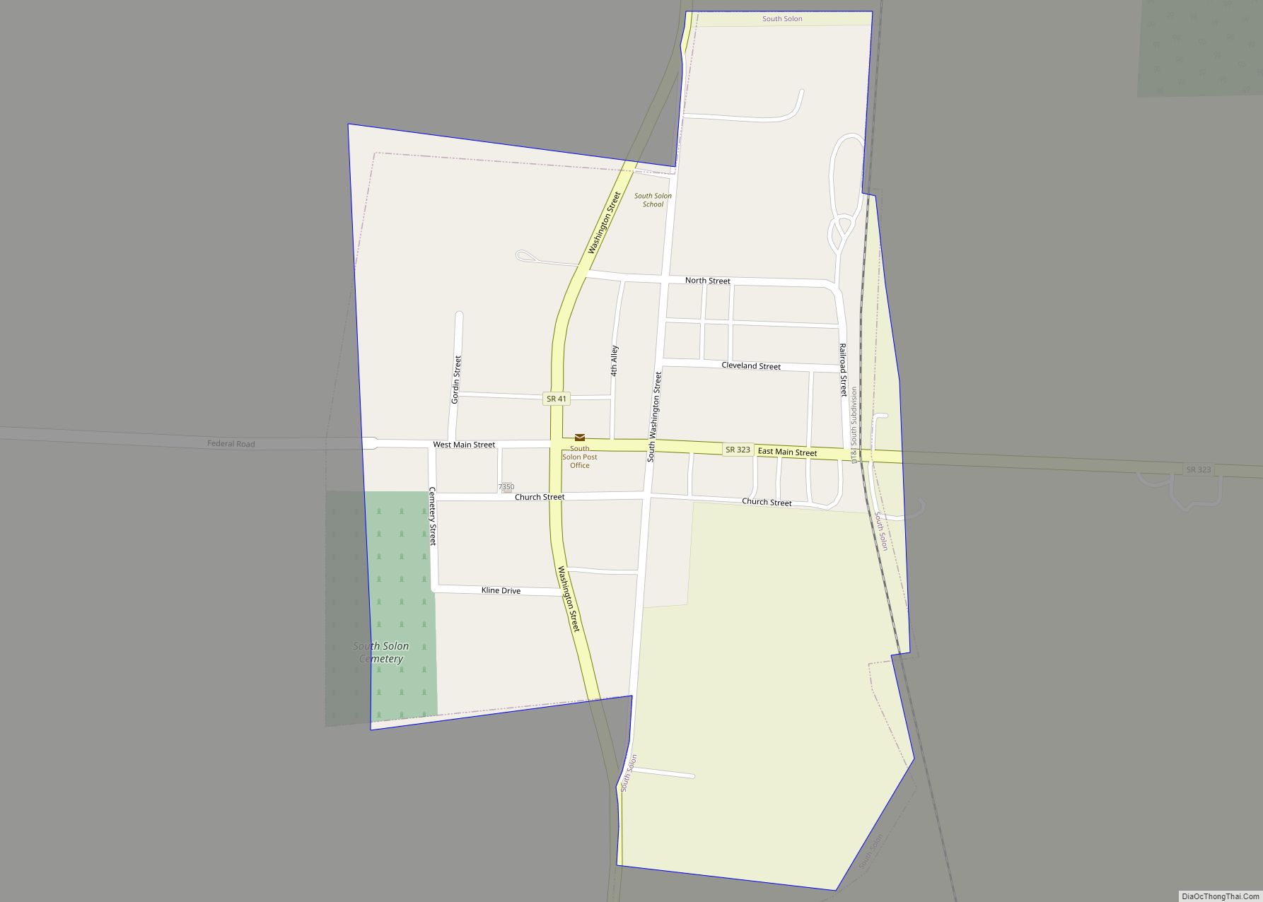
South Solon is a village in Madison County, Ohio, United States. The population was 355 at the 2010 census. Despite their similar names, South Solon is not adjacent to the city of Solon, Ohio, a suburb of Cleveland in Cuyahoga County. The two towns are approximately 170 miles (270 km) apart. South Solon village overview: Name: ... Read more
Map of South Solon village
Map of South Salem village
South Salem is a village in Ross County, Ohio, United States. The population was 204 at the 2010 census. South Salem village overview: Name: South Salem village LSAD Code: 47 LSAD Description: village (suffix) State: Ohio County: Ross County Elevation: 919 ft (280 m) Total Area: 0.18 sq mi (0.47 km²) Land Area: 0.18 sq mi (0.47 km²) Water Area: 0.00 sq mi (0.00 km²) Total ... Read more
Map of South Salem village
Map of South Russell village
South Russell is a village in Geauga County, Ohio, United States. The population was 3,972 at the 2020 census. It is part of the Cleveland metropolitan area. South Russell village overview: Name: South Russell village LSAD Code: 47 LSAD Description: village (suffix) State: Ohio County: Geauga County Elevation: 1,122 ft (342 m) Total Area: 3.86 sq mi (10.00 km²) Land ... Read more
Map of South Russell village
Map of South Point village, Ohio
South Point is a village in Lawrence County, Ohio, United States, along the Ohio River. The population was 3,836 at the 2020 census. It is part of the Huntington–Ashland metropolitan area. The village mayor is Jeff Gaskin, who was elected in November 2015. South Point village overview: Name: South Point village LSAD Code: 47 LSAD ... Read more
Map of South Point village, Ohio
Map of South Lebanon village, Ohio
South Lebanon is a city located in Union and Hamilton Townships in central Warren County in the southwestern part of the U.S. state of Ohio. The population was 6,384 at the 2020 census. South Lebanon village overview: Name: South Lebanon village LSAD Code: 47 LSAD Description: village (suffix) State: Ohio County: Warren County Elevation: 623 ft ... Read more
Map of South Lebanon village, Ohio
Map of South Euclid city
South Euclid is a city in Cuyahoga County, Ohio, United States. It is an inner-ring suburb of Cleveland located on the city’s east side. As of the 2010 census the population was 22,295. South Euclid city overview: Name: South Euclid city LSAD Code: 25 LSAD Description: city (suffix) State: Ohio County: Cuyahoga County Elevation: 958 ft ... Read more
Map of South Euclid city
Map of South Charleston village, Ohio
South Charleston is a village in Clark County, Ohio, United States. The population was 1,693 at the 2010 census. It is part of the Springfield, Ohio Metropolitan Statistical Area. Despite its name implying that South Charleston is related to a city named Charleston, there is no city by that name in Ohio. South Charleston village ... Read more
Map of South Charleston village, Ohio
Map of South Canal CDP
South Canal is an unincorporated community and census-designated place in western Newton Township, Trumbull County, Ohio, United States. The population was 1,101 at the 2020 census. It is part of the Youngstown–Warren metropolitan area. South Canal CDP overview: Name: South Canal CDP LSAD Code: 57 LSAD Description: CDP (suffix) State: Ohio County: Trumbull County Elevation: ... Read more
Map of South Canal CDP
Map of South Bloomfield village
South Bloomfield is a village in Pickaway County, Ohio, United States. The population was 1,744 at the 2010 census. It has consistently been one of the fastest-growing villages in central Ohio. South Bloomfield village overview: Name: South Bloomfield village LSAD Code: 47 LSAD Description: village (suffix) State: Ohio County: Pickaway County Elevation: 696 ft (212 m) Total ... Read more
Map of South Bloomfield village
Map of South Zanesville village
South Zanesville is a village in Muskingum County, Ohio, United States, along the Muskingum River near the mouth of the Moxahala Creek. The population was 1,894 at the 2020 census. It is part of the Zanesville micropolitan area. South Zanesville village overview: Name: South Zanesville village LSAD Code: 47 LSAD Description: village (suffix) State: Ohio ... Read more
Map of South Zanesville village
Map of South Webster village
South Webster is a village in northeast Scioto County, Ohio, United States. It lies along State Route 140, and the population was 866 at the 2010 census. South Webster village overview: Name: South Webster village LSAD Code: 47 LSAD Description: village (suffix) State: Ohio County: Scioto County Elevation: 715 ft (218 m) Total Area: 1.32 sq mi (3.43 km²) Land ... Read more
Map of South Webster village
Map of St. Clairsville city, Ohio
St. Clairsville is a city in and the county seat of Belmont County, Ohio, United States. The population was 5,096 at the 2020 census. It is part of the Wheeling metropolitan area. St. Clairsville city overview: Name: St. Clairsville city LSAD Code: 25 LSAD Description: city (suffix) State: Ohio County: Belmont County Elevation: 1,273 ft (388 m) ... Read more
Map of St. Clairsville city, Ohio