Map of South Zanesville village
South Zanesville is a village in Muskingum County, Ohio, United States, along the Muskingum River near the mouth of the Moxahala Creek. The population was 1,894 at the 2020 census. It is part of the Zanesville micropolitan area. South Zanesville village overview: Name: South Zanesville village LSAD Code: 47 LSAD Description: village (suffix) State: Ohio ... Read more
Map of South Zanesville village
Map of South Webster village
South Webster is a village in northeast Scioto County, Ohio, United States. It lies along State Route 140, and the population was 866 at the 2010 census. South Webster village overview: Name: South Webster village LSAD Code: 47 LSAD Description: village (suffix) State: Ohio County: Scioto County Elevation: 715 ft (218 m) Total Area: 1.32 sq mi (3.43 km²) Land ... Read more
Map of South Webster village
Map of St. Clairsville city, Ohio
St. Clairsville is a city in and the county seat of Belmont County, Ohio, United States. The population was 5,096 at the 2020 census. It is part of the Wheeling metropolitan area. St. Clairsville city overview: Name: St. Clairsville city LSAD Code: 25 LSAD Description: city (suffix) State: Ohio County: Belmont County Elevation: 1,273 ft (388 m) ... Read more
Map of St. Clairsville city, Ohio
Map of St. Bernard village
St. Bernard is a village in Hamilton County, Ohio, United States. The population was 4,070 at the 2020 census. St. Bernard village overview: Name: St. Bernard village LSAD Code: 47 LSAD Description: village (suffix) State: Ohio County: Hamilton County Elevation: 558 ft (170 m) Total Area: 1.54 sq mi (4.00 km²) Land Area: 1.53 sq mi (3.97 km²) Water Area: 0.01 sq mi (0.02 km²) Total ... Read more
Map of St. Bernard village
Map of Springdale city, Ohio
Springdale is a city in Hamilton County, Ohio, United States. It is a suburb of Cincinnati. The population was 11,007 at the 2020 census. Springdale city overview: Name: Springdale city LSAD Code: 25 LSAD Description: city (suffix) State: Ohio County: Hamilton County Elevation: 738 ft (225 m) Total Area: 4.99 sq mi (12.92 km²) Land Area: 4.98 sq mi (12.89 km²) Water Area: ... Read more
Map of Springdale city, Ohio
Map of Springboro city, Ohio
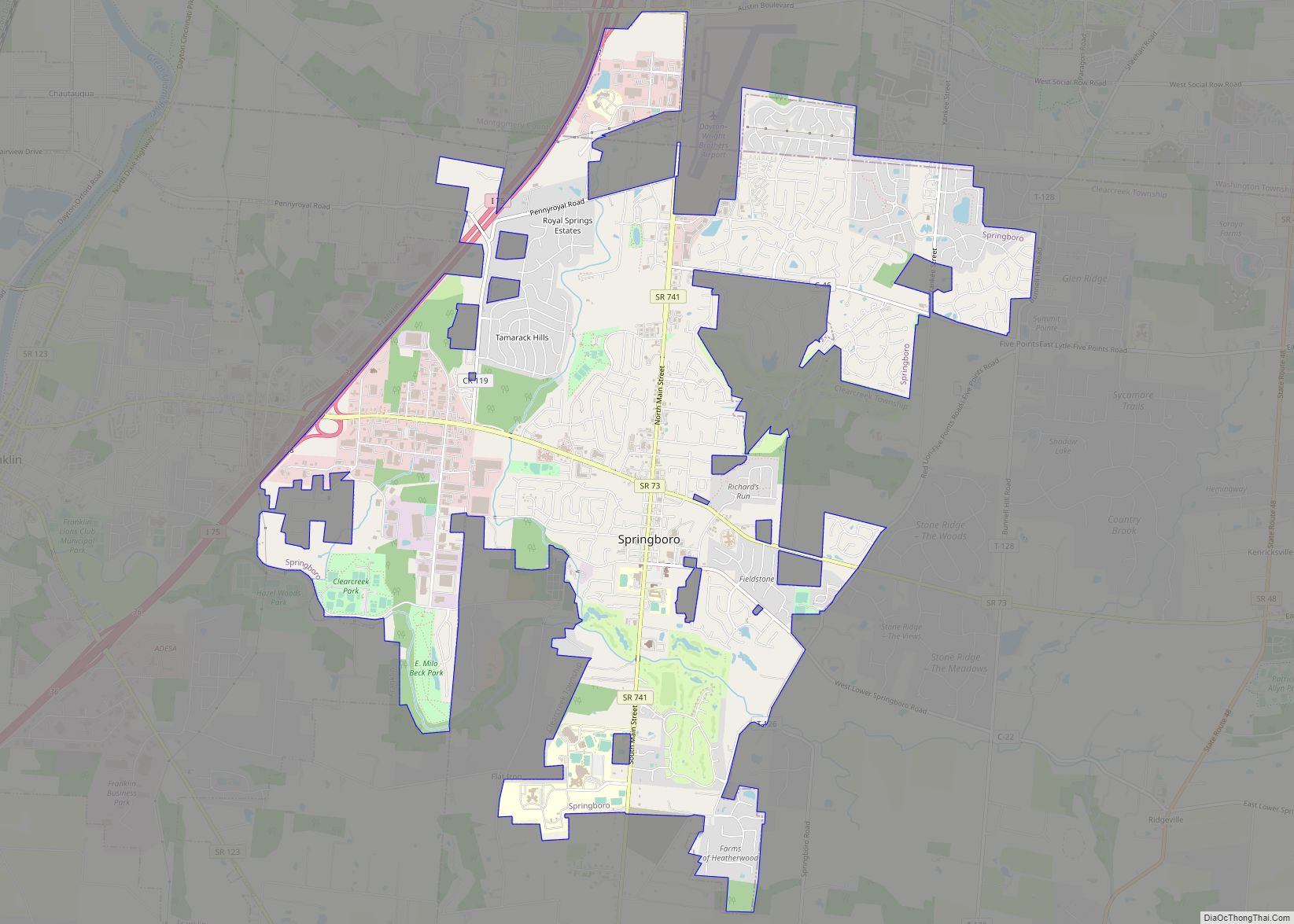
Springboro is a city in the U.S. state of Ohio. A suburb of Cincinnati and Dayton, it is located mostly in Warren County in Clearcreek and Franklin Townships; with a small portion in Miami Township in Montgomery County. The city is part of the Miami Valley. As of the 2020 census, the city had a ... Read more
Map of Springboro city, Ohio
Map of Spring Valley village, Ohio
Spring Valley is a village in Greene County, Ohio, United States. The population was 476 at the 2010 census. It is part of the Dayton Metropolitan Statistical Area. Spring Valley village overview: Name: Spring Valley village LSAD Code: 47 LSAD Description: village (suffix) State: Ohio County: Greene County Elevation: 761 ft (232 m) Total Area: 0.27 sq mi (0.69 km²) ... Read more
Map of Spring Valley village, Ohio
Map of Stewart CDP, Ohio
Stewart is an unincorporated community and census-designated place in central Rome Township, Athens County, Ohio, United States. The population was 221 at the 2020 census. It has a post office with the ZIP code 45778. Stewart CDP overview: Name: Stewart CDP LSAD Code: 57 LSAD Description: CDP (suffix) State: Ohio County: Athens County Total Area: ... Read more
Map of Stewart CDP, Ohio
Map of Steubenville city
Steubenville is a city in and the county seat of Jefferson County, Ohio, United States. Located along the Ohio River 33 miles west of Pittsburgh, it had a population of 18,161 at the 2020 census. The city’s name is derived from Fort Steuben, a 1786 fort that sat within the city’s current limits and was ... Read more
Map of Steubenville city
Map of Sterling CDP, Ohio
Sterling is an unincorporated, census-designated place in northwestern Milton Township, Wayne County, Ohio, United States with the ZIP code of 44276. Sterling CDP overview: Name: Sterling CDP LSAD Code: 57 LSAD Description: CDP (suffix) State: Ohio County: Wayne County FIPS code: 3974566 Online Interactive Map Sterling online map. Source: Basemap layers from Google Map, Open ... Read more
Map of Sterling CDP, Ohio
Map of Stafford village, Ohio
Stafford is a village in Monroe County, Ohio, United States. The population was 71 at the 2020 census. Stafford village overview: Name: Stafford village LSAD Code: 47 LSAD Description: village (suffix) State: Ohio County: Monroe County Elevation: 1,079 ft (329 m) Total Area: 0.34 sq mi (0.88 km²) Land Area: 0.34 sq mi (0.88 km²) Water Area: 0.00 sq mi (0.00 km²) Total Population: 71 Population ... Read more
Map of Stafford village, Ohio
Map of St. Paris village
St. Paris is a village in Champaign County, Ohio, United States. The population was 2,089 at the 2010 census. St. Paris village overview: Name: St. Paris village LSAD Code: 47 LSAD Description: village (suffix) State: Ohio County: Champaign County Elevation: 1,207 ft (368 m) Total Area: 1.62 sq mi (4.20 km²) Land Area: 1.62 sq mi (4.20 km²) Water Area: 0.00 sq mi (0.00 km²) Total ... Read more
Map of St. Paris village