Map of Carlton Landing town

Map of Carlton Landing town

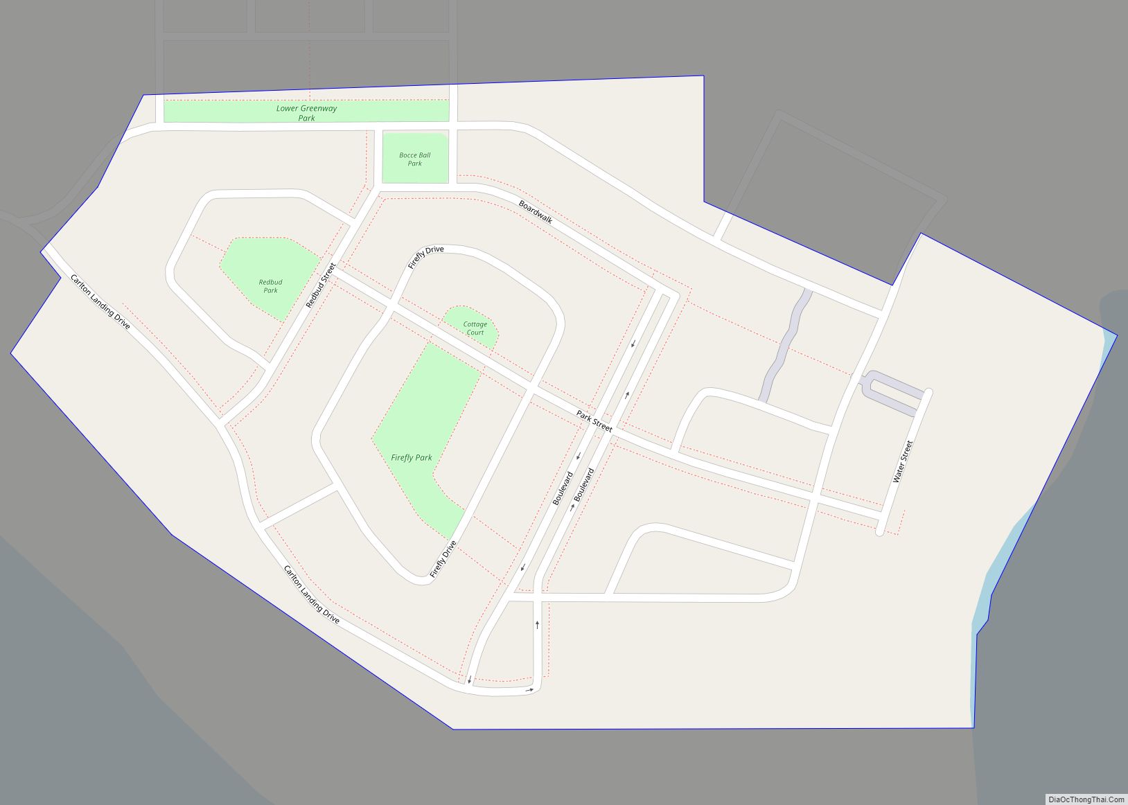
Carlton Landing is a master-planned resort town in Pittsburg County, Oklahoma, United States, conceived and built by real estate developer Grant Humphreys. It was established on October 21, 2013, and had a population of 94 as of 2020. Carlton Landing town overview: Name: Carlton Landing town LSAD Code: 43 LSAD Description: town (suffix) State: Oklahoma … Read more

Map of Carlisle CDP, Oklahoma

Map of Carlisle CDP, Oklahoma

Carlisle is a census-designated place (CDP) in Sequoyah County, Oklahoma, United States. It is part of the Fort Smith, Arkansas-Oklahoma Metropolitan Statistical Area. The population was 606 at the 2010 census. Carlisle CDP overview: Name: Carlisle CDP LSAD Code: 57 LSAD Description: CDP (suffix) State: Oklahoma County: Sequoyah County Total Area: 26.44 sq mi (68.47 km²) Land Area: … Read more

Map of Capron town, Oklahoma

Map of Capron town, Oklahoma

Capron town overview: Name: Capron town LSAD Code: 43 LSAD Description: town (suffix) State: Oklahoma County: Woods County FIPS code: 4011750 Online Interactive Map Capron online map. Source: Basemap layers from Google Map, Open Street Map (OSM), Arcgisonline, Wmflabs. Boundary Data from Database of Global Administrative Areas. Capron location map. Where is Capron town? Capron … Read more

Map of Canute town

Map of Canute town

Canute is a town in Washita County, Oklahoma, United States. The population was 541 at the 2010 census. Canute town overview: Name: Canute town LSAD Code: 43 LSAD Description: town (suffix) State: Oklahoma County: Washita County Elevation: 1,896 ft (578 m) Total Area: 0.63 sq mi (1.63 km²) Land Area: 0.63 sq mi (1.63 km²) Water Area: 0.00 sq mi (0.00 km²) Total Population: 494 Population … Read more

Map of Canton town, Oklahoma

Map of Canton town, Oklahoma

Canton is a town in Blaine County, Oklahoma, United States. The population was 625 at the 2010 census. Canton town overview: Name: Canton town LSAD Code: 43 LSAD Description: town (suffix) State: Oklahoma County: Blaine County Elevation: 1,588 ft (484 m) Total Area: 0.52 sq mi (1.36 km²) Land Area: 0.52 sq mi (1.36 km²) Water Area: 0.00 sq mi (0.00 km²) Total Population: 468 Population … Read more

Map of Caney town, Oklahoma

Map of Caney town, Oklahoma

Caney is a town in Atoka County, Oklahoma, United States. The population was 205 at the 2010 census. Caney town overview: Name: Caney town LSAD Code: 43 LSAD Description: town (suffix) State: Oklahoma County: Atoka County Elevation: 600 ft (183 m) Total Area: 0.76 sq mi (1.96 km²) Land Area: 0.76 sq mi (1.96 km²) Water Area: 0.00 sq mi (0.00 km²) Total Population: 185 Population … Read more

Map of Canadian town

Map of Canadian town, Oklahoma

Canadian is a town in Pittsburg County, Oklahoma, United States. The population was 239 at the 2000 census. Canadian town overview: Name: Canadian town LSAD Code: 43 LSAD Description: town (suffix) State: Oklahoma County: Pittsburg County Elevation: 665 ft (203 m) Total Area: 0.76 sq mi (1.96 km²) Land Area: 0.76 sq mi (1.96 km²) Water Area: 0.00 sq mi (0.00 km²) Total Population: 143 Population … Read more

Map of Cameron town, Oklahoma

Map of Cameron town, Oklahoma

Cameron is a town in Le Flore County, Oklahoma, United States. It is part of the Fort Smith, Arkansas-Oklahoma Metropolitan Statistical Area. The population was 302 at the 2010 census, a decline of 3.2 percent from the figure of 312 recorded in 2000. Cameron town overview: Name: Cameron town LSAD Code: 43 LSAD Description: town … Read more

Map of Cedar Valley city

Map of Cedar Valley city

Cedar Valley is a city in Logan County, Oklahoma, United States. The population was 288 at the 2010 census, nearly five times the figure of 58 in 2000. It is part of the Oklahoma City Metropolitan Statistical Area. It is primarily a bedroom community, since more than 90 percent of the employed inhabitants commute to … Read more

Map of Cedar Crest CDP, Oklahoma

Map of Cedar Crest CDP, Oklahoma

Cedar Crest is a census-designated place (CDP) in Mayes County, Oklahoma, United States. The population was 312 at the 2010 census, almost unchanged from the figure of 308 recorded in 2000. Cedar Crest CDP overview: Name: Cedar Crest CDP LSAD Code: 57 LSAD Description: CDP (suffix) State: Oklahoma County: Mayes County Elevation: 659 ft (201 m) Total … Read more

Map of Cayuga CDP, Oklahoma

Map of Cayuga CDP, Oklahoma

Cayuga Springs is an unincorporated community and census-designated place (CDP) in Delaware County, Oklahoma, United States. The population was 140 at the 2010 census, a 33.3 percent increase over the figure of 105 recorded in 2000. It was established on the Elk River in the old Seneca Reserve in Indian Territory. The Cayuga Springs Post … Read more

Map of Catoosa city

Map of Catoosa city

Catoosa is a city in Rogers and Wagoner counties in the U.S. state of Oklahoma. The population was 7,159 at the 2010 census compared to 5,449 at the 2000 census. This was a 31.2 percent increase during the decade. Catoosa city overview: Name: Catoosa city LSAD Code: 25 LSAD Description: city (suffix) State: Oklahoma County: … Read more