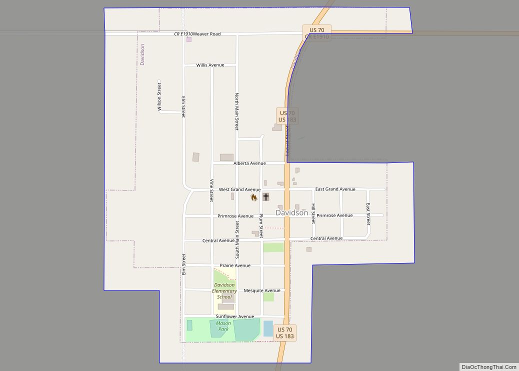
Map of Dacoma town
Dacoma is a town in Woods County, Oklahoma, United States. The population was 107 at the 2010 census, down from 148 in 2000. Dacoma shares a school district with the nearby town of Carmen. Dacoma town overview: Name: Dacoma town LSAD Code: 43 LSAD Description: town (suffix) State: Oklahoma County: Woods County Elevation: 1,365 ft (416 m) ... Read more
Map of Dacoma town
Map of Cyril town
Cyril is a town in Caddo County, Oklahoma, United States. The population was 1,059 at the 2010 census. Cyril town overview: Name: Cyril town LSAD Code: 43 LSAD Description: town (suffix) State: Oklahoma County: Caddo County Elevation: 1,362 ft (415 m) Total Area: 0.57 sq mi (1.48 km²) Land Area: 0.57 sq mi (1.48 km²) Water Area: 0.00 sq mi (0.00 km²) Total Population: 827 Population ... Read more
Map of Cyril town
Map of Custer City town
Custer City is a town in Custer County, Oklahoma, United States. Custer City is northeast of Clinton and northwest of Weatherford along Oklahoma 33. The population was 375 at the 2010 census. Custer City was originally known as Graves, and a post office was established there on January 22, 1894. The post office changed its ... Read more
Map of Custer City town
Map of Del City
Del City is a city in Oklahoma County, Oklahoma, United States, and a part of the Oklahoma City metropolitan area. The population was 21,822 at the United States Census, 2020, a 2.3% increase from 2010. Del City is located near two major interstate highways, both of which connect it to Oklahoma City. Interstate 40 bisects ... Read more
Map of Del City
Map of Deer Lick CDP
Deer Lick is an unincorporated community and census-designated place (CDP) in Delaware County, Oklahoma, United States. The population was 46 at the 2010 census. Deer Lick CDP overview: Name: Deer Lick CDP LSAD Code: 57 LSAD Description: CDP (suffix) State: Oklahoma County: Delaware County Elevation: 1,060 ft (320 m) Total Area: 0.95 sq mi (2.47 km²) Land Area: 0.95 sq mi (2.47 km²) ... Read more
Map of Deer Lick CDP
Map of Deer Creek town, Oklahoma
Deer Creek is a town in Grant County, Oklahoma, United States. The population was 130 at the 2010 census, an 11.6 percent decrease from the figure of 147 in 2000. It was named for a nearby stream, which is a tributary of the Salt Fork of the Arkansas River. Deer Creek town overview: Name: Deer ... Read more
Map of Deer Creek town, Oklahoma
Map of Disney town
Disney is a town in Mayes County, Oklahoma, United States. The population was 311 at the 2010 census. The town is named for former Oklahoma U.S. Congressman Wesley E. Disney and has no affiliation with The Walt Disney Company or Walt Disney. Disney town overview: Name: Disney town LSAD Code: 43 LSAD Description: town (suffix) ... Read more
Map of Disney town
Map of Dill City town
Dill City is a town in Washita County, Oklahoma, United States. The population was 562 at the 2010 census. Dill City town overview: Name: Dill City town LSAD Code: 43 LSAD Description: town (suffix) State: Oklahoma County: Washita County Elevation: 1,854 ft (565 m) Total Area: 0.58 sq mi (1.50 km²) Land Area: 0.58 sq mi (1.50 km²) Water Area: 0.00 sq mi (0.00 km²) Total ... Read more
Map of Dill City town
Map of Dickson town, Oklahoma
Dickson is a town in Carter County, Oklahoma, United States. The population was 1,207 at the 2010 census. It is part of the Ardmore, Oklahoma Micropolitan Statistical Area. Dickson town overview: Name: Dickson town LSAD Code: 43 LSAD Description: town (suffix) State: Oklahoma County: Carter County Total Area: 14.08 sq mi (36.47 km²) Land Area: 13.96 sq mi (36.17 km²) Water ... Read more
Map of Dickson town, Oklahoma
Map of Dibble town
Dibble is a town in McClain County, Oklahoma, United States. The population within city limits was 867 at the 2020 census, down from 878 at the 2010 census. The community has 8,868 residents in its 73031 zipcode, according to Sperling’s Best Places. Dibble is in the outer suburban area west of Purcell and southwest of ... Read more
Map of Dibble town
Map of Dewey city
Dewey is a city in Washington County, Oklahoma, United States. Founded by Jacob A. Bartles in 1899, the town was named for Admiral George Dewey. It was incorporated December 8, 1905. The population was 3,179 at the 2000 census and 3,432 at the 2010 census, an increase of 8 percent. Dewey city overview: Name: Dewey ... Read more
Map of Dewey city
Map of Dewar town
Dewar is a town in Okmulgee County, Oklahoma, United States. The population was 818 at the 2010 census, a decline of 11.0 percent from the figure of 919 recorded in 2000. Founded in 1909 by workers for the Missouri, Oklahoma and Gulf Railway (MO&G), it was named for William Peter Dewar, a railroad official. It ... Read more
Map of Dewar town