Map of Richland city, Oregon

Map of Richland city, Oregon

Richland is a city in Baker County, Oregon, United States. The population was 156 at the 2010 census. Richland city overview: Name: Richland city LSAD Code: 25 LSAD Description: city (suffix) State: Oregon County: Baker County Incorporated: 1917 Elevation: 2,231 ft (680 m) Total Area: 0.10 sq mi (0.27 km²) Land Area: 0.10 sq mi (0.27 km²) Water Area: 0.00 sq mi (0.00 km²) Total Population: … Read more

Map of Reedsport city

Map of Reedsport city

Reedsport is a city in northwest Douglas County, Oregon, United States. As of the 2020 census, the population was 4,310. Reedsport city overview: Name: Reedsport city LSAD Code: 25 LSAD Description: city (suffix) State: Oregon County: Douglas County Incorporated: 1919 Elevation: 3 ft (0.9 m) Total Area: 2.30 sq mi (5.96 km²) Land Area: 2.07 sq mi (5.36 km²) Water Area: 0.23 sq mi (0.60 km²) … Read more

Map of Redwood CDP, Oregon

Map of Redwood CDP, Oregon

Redwood is a census-designated place (CDP) in Josephine County, Oregon, United States. The population was 2,627 at the 2010 census, down from 5,844 at the 2000 census as it has lost territory to the neighboring city of Grants Pass. Redwood CDP overview: Name: Redwood CDP LSAD Code: 57 LSAD Description: CDP (suffix) State: Oregon County: … Read more

Map of Rogue River city

Map of Rogue River city

Rogue River is a city in Jackson County, Oregon, United States. As of the 2020 census the population was 2,407. Rogue River city overview: Name: Rogue River city LSAD Code: 25 LSAD Description: city (suffix) State: Oregon County: Jackson County Incorporated: 1912 Elevation: 1,004 ft (306 m) Total Area: 0.96 sq mi (2.50 km²) Land Area: 0.96 sq mi (2.50 km²) Water Area: … Read more

Map of Rockcreek CDP

Map of Rockcreek CDP

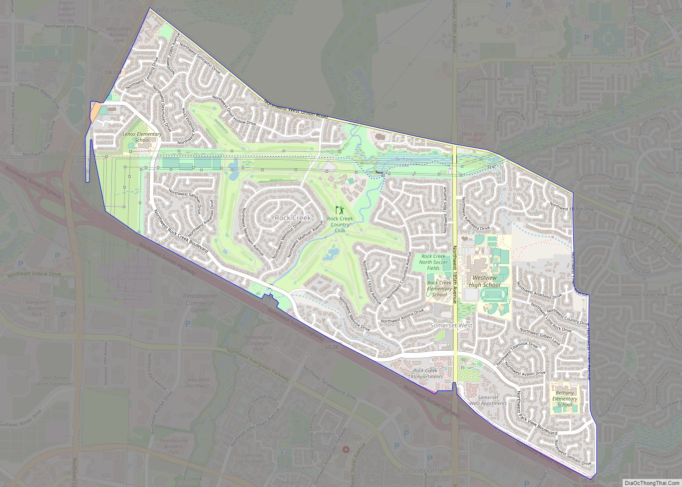
Rockcreek is a census-designated place in Washington County, Oregon, United States, north of U.S. Route 26. It is named for the Rock Creek neighborhood in the area. As of the 2010 census, the CDP population was 9,316. Rockcreek CDP overview: Name: Rockcreek CDP LSAD Code: 57 LSAD Description: CDP (suffix) State: Oregon County: Washington County … Read more

Map of Rockaway Beach city, Oregon

Map of Rockaway Beach city, Oregon

Rockaway Beach is a city in Tillamook County, Oregon, United States. The population was 1,312 at the 2010 census. The city houses the Rockaway Beach Old Growth Cedar Preserve, a 46-acre wetlands preserve which opened in 2019. The preserve has an elevated walkway, which terminates at a large cedar tree known as The Big Tree, … Read more

Map of Riverside CDP, Oregon

Map of Riverside CDP, Oregon

Riverside is a census-designated place (CDP) in Umatilla County, Oregon, United States. The population was 189 at the 2000 census. It is part of the Pendleton–Hermiston Micropolitan Statistical Area. Riverside CDP overview: Name: Riverside CDP LSAD Code: 57 LSAD Description: CDP (suffix) State: Oregon County: Umatilla County Total Area: 0.6 sq mi (1.6 km²) Land Area: 0.6 sq mi (1.6 km²) … Read more

Map of Rivergrove city

Map of Rivergrove city

Rivergrove is a city in Clackamas County, Oregon, United States. A small portion of the city extends into nearby Washington County. Its name is a portmanteau of the Tualatin River, which forms its southern border, and Lake Grove, a community that is now part of Lake Oswego. The population was 370 at the 2010 census. … Read more

Map of Scotts Mills city

Map of Scotts Mills city

Scotts Mills is a city in Marion County, Oregon, United States. The population was 419 at the 2020 census. It is 2 miles (3 km) south of Marquam and Oregon Route 213, between Silverton and Molalla. Scotts Mills is part of the Salem Metropolitan Statistical Area. It is near the site of the 1993 Scotts Mills … Read more

Map of Scio city, Oregon

Map of Scio city, Oregon

Scio (/ˈsaɪoʊ/ SY-oh) is a city in Linn County, Oregon, United States. The population was 838 at the 2010 census. Scio city overview: Name: Scio city LSAD Code: 25 LSAD Description: city (suffix) State: Oregon County: Linn County Incorporated: 1866 Elevation: 317 ft (96.6 m) Total Area: 0.43 sq mi (1.13 km²) Land Area: 0.43 sq mi (1.13 km²) Water Area: 0.00 sq mi (0.00 km²) … Read more

Map of Scappoose city

Map of Scappoose city

Scappoose /skæˈpuːs/ is a city in Columbia County, Oregon, United States. It was named for a nearby stream, which drains the southern part of the county. The name “Scappoose” is of Native American origin, and is said to mean “gravelly plain.” The population was 6,592 at the 2010 census. Scappoose city overview: Name: Scappoose city … Read more

Map of Sandy city

Map of Sandy city, Oregon

Sandy is a city located in Clackamas County, Oregon, United States, settled c. 1853 and named after the nearby Sandy River. Located in the foothills of the Cascade Mountain Range, the city serves as the western gateway to the Mount Hood Corridor, and is located approximately 27 miles (43 km) east of Portland. The city of … Read more