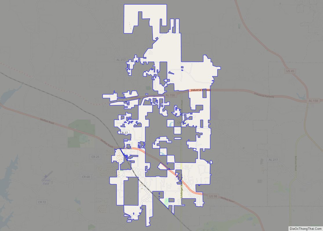
Map of Selmont-West Selmont CDP
Selmont-West Selmont is a census-designated place (CDP) in Dallas County, Alabama, United States. At the 2020 census, the population was 2,158. Selmont-West Selmont CDP overview: Name: Selmont-West Selmont CDP LSAD Code: 57 LSAD Description: CDP (suffix) State: Alabama County: Dallas County Elevation: 117 ft (36 m) Total Area: 3.32 sq mi (8.59 km²) Land Area: 3.28 sq mi (8.49 km²) Water Area: 0.04 sq mi ... Read more
Map of Selmont-West Selmont CDP
Map of Selma city, Alabama
Selma is a city in and the county seat of Dallas County, in the Black Belt region of south central Alabama and extending to the west. Located on the banks of the Alabama River, the city has a population of 17,971 as of the 2020 census. About 80% of the population is African-American. Selma was ... Read more
Map of Selma city, Alabama
Map of Shiloh town, Alabama
Shiloh is a town in DeKalb County, Alabama, United States. It incorporated in 1962. At the 2020 census, the population was 321. Shiloh is located atop Sand Mountain. Shiloh town overview: Name: Shiloh town LSAD Code: 43 LSAD Description: town (suffix) State: Alabama County: DeKalb County Elevation: 1,204 ft (367 m) Total Area: 2.13 sq mi (5.52 km²) Land Area: ... Read more
Map of Shiloh town, Alabama
Map of Shelby CDP, Alabama
Shelby is a census-designated place and unincorporated community in Shelby County, Alabama, United States. Its population was 1,044 as of the 2010 census. The area is near Lay Lake and Waxahatchee Creek. Shelby Iron Park is located at the heart of the area. Two sites in Shelby, The Brick House and the Old Shelby Hotel, ... Read more
Map of Shelby CDP, Alabama
Map of Sheffield city, Alabama
Sheffield is a city in Colbert County, Alabama, United States, and is included in the Florence-Shoals metropolitan area. As of the 2010 census, the population of the city was 9,039. Sheffield is the birthplace of “country-soul pioneer” and songwriter Arthur Alexander, French horn player Willie Ruff, notable attorney, actor, former senator and presidential contender Fred ... Read more
Map of Sheffield city, Alabama
Map of Silas town
Silas is a town in Choctaw County, Alabama, United States. At the 2020 census, the population was 377. The town was struck by a tornado on March 17, 2021. The tornado downed trees and inflicted minor damage to outbuildings and homes at EF1 strength. It reached EF2 strength well northeast of town and injured two people. Silas ... Read more
Map of Silas town
Map of Shorter town
Shorter is a town in Macon County, Alabama, United States. At the 2020 census the population was 385, down from 474 at the 2010 census. According to the 1990 U.S. Census records, it was incorporated in 1984. Shorter town overview: Name: Shorter town LSAD Code: 43 LSAD Description: town (suffix) State: Alabama County: Macon County ... Read more
Map of Shorter town
Map of Shoal Creek CDP
Shoal Creek is a private, gated/guarded residential community in Shelby County, Alabama, United States. Its population was 274 as of the 2010 census. The population is constantly fluctuating. The community has many features to provide its residents. Shoal Creek Golf and Country Club is located in Shoal Creek. Home of the 2018 U.S. Women’s Open ... Read more
Map of Shoal Creek CDP
Map of Silverhill town
Silverhill is a town in Baldwin County, Alabama, United States. As of the 2010 census, the population was 706. It is part of the Daphne-Fairhope-Foley metropolitan area. Silverhill town overview: Name: Silverhill town LSAD Code: 43 LSAD Description: town (suffix) State: Alabama County: Baldwin County Elevation: 141 ft (43 m) Total Area: 1.26 sq mi (3.26 km²) Land Area: 1.26 sq mi ... Read more
Map of Silverhill town
Map of Sipsey town
Sipsey is a town in Walker County, Alabama, United States. At the 2010 census the population was 437, down from 552. Sipsey town overview: Name: Sipsey town LSAD Code: 43 LSAD Description: town (suffix) State: Alabama County: Walker County Elevation: 430 ft (130 m) Total Area: 0.48 sq mi (1.25 km²) Land Area: 0.48 sq mi (1.24 km²) Water Area: 0.00 sq mi (0.00 km²) Total ... Read more
Map of Sipsey town
Map of Sims Chapel CDP
Sims Chapel (also Darrah, Grandfield) is a census-designated place and unincorporated community in Washington County, Alabama, United States. Its population was 153 as of the 2010 census. Sims Chapel CDP overview: Name: Sims Chapel CDP LSAD Code: 57 LSAD Description: CDP (suffix) State: Alabama County: Washington County Elevation: 85 ft (26 m) Total Area: 5.73 sq mi (14.85 km²) Land ... Read more
Map of Sims Chapel CDP
Map of Smiths Station city
Smiths Station is a city in Lee County, Alabama. It is part of the Columbus metropolitan area, Georgia. At the time of the 2000 census, it was still a census-designated place (CDP), and its population was 6,756. The area that incorporated as Smiths Station in 2001 was much smaller than the CDP, and contained a ... Read more
Map of Smiths Station city