Map of Elkins city, Arkansas
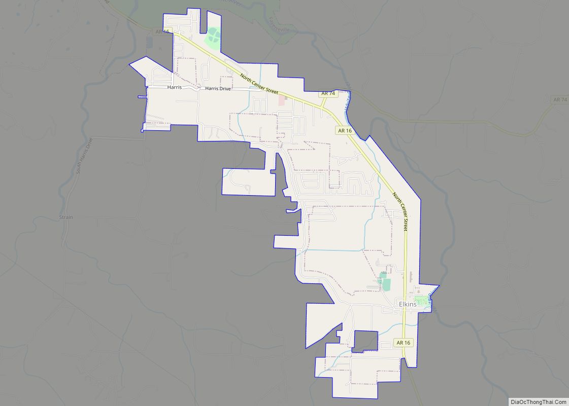
Elkins is a city in Washington County, Arkansas, United States. The community is located in the Boston Mountains, deep in the Ozark Mountains. A combination of the former unincorporated communities of Harris and Hood, Elkins was established in 1964. Located immediately east of Fayetteville in the Northwest Arkansas metropolitan statistical area, Elkins has been experiencing ... Read more
Map of Elkins city, Arkansas
Map of Elaine city
Elaine is a small town in Phillips County, Arkansas, United States, in the Arkansas Delta region of the Mississippi River. The population was 636 at the 2010 census. The city is best known as the location of the Elaine massacre of September 30–October 1, 1919, in which an estimated 237 black people were killed in ... Read more
Map of Elaine city
Map of England city
England is a city in southwestern Lonoke County, Arkansas, United States and the county’s fourth most populous city. The population was 2,825 at the 2010 census. It is part of the Little Rock–North Little Rock–Conway Metropolitan Statistical Area. England city overview: Name: England city LSAD Code: 25 LSAD Description: city (suffix) State: Arkansas County: Lonoke ... Read more
Map of England city
Map of Emmet city, Arkansas
Emmet is a city in Nevada and Hempstead counties in the U.S. state of Arkansas. It is located at the intersection of U.S. Highway 67 and Arkansas Highway 299 in the Arkansas Timberlands region of southwest Arkansas. It is part of the larger Ark-La-Tex tri-state region. As of the 2010 census, the population of Emmet ... Read more
Map of Emmet city, Arkansas
Map of Emerson town, Arkansas
Emerson is a town in Columbia County, Arkansas, United States. The population was 368 at the 2010 census. Emerson town overview: Name: Emerson town LSAD Code: 43 LSAD Description: town (suffix) State: Arkansas County: Columbia County Elevation: 322 ft (98 m) Total Area: 0.99 sq mi (2.57 km²) Land Area: 0.99 sq mi (2.57 km²) Water Area: 0.00 sq mi (0.00 km²) Total Population: 293 Population ... Read more
Map of Emerson town, Arkansas
Map of Etowah town, Arkansas
Etowah is a town in Mississippi County, Arkansas, United States. The population was 254 at the 2020 census, down from 351 in 2010. Etowah town overview: Name: Etowah town LSAD Code: 43 LSAD Description: town (suffix) State: Arkansas County: Mississippi County Elevation: 230 ft (70 m) Total Area: 5.94 sq mi (15.39 km²) Land Area: 5.94 sq mi (15.38 km²) Water Area: 0.01 sq mi ... Read more
Map of Etowah town, Arkansas
Map of Enola town, Arkansas
Enola is a town in Faulkner County, Arkansas, United States. It is part of the Little Rock–North Little Rock–Conway Metropolitan Statistical Area. The population was 338 at the 2010 census, up from 188 at the 2000 census. Enola town overview: Name: Enola town LSAD Code: 43 LSAD Description: town (suffix) State: Arkansas County: Faulkner County ... Read more
Map of Enola town, Arkansas
Map of Eudora city, Arkansas
Eudora is a city in Chicot County, Arkansas, United States. The population was 2,269 at the 2010 census, down from 2,819 in 2000. Eudora city overview: Name: Eudora city LSAD Code: 25 LSAD Description: city (suffix) State: Arkansas County: Chicot County Elevation: 135 ft (41 m) Total Area: 3.09 sq mi (8.01 km²) Land Area: 3.09 sq mi (8.01 km²) Water Area: 0.00 sq mi ... Read more
Map of Eudora city, Arkansas
Map of Everton town, Arkansas
Everton is a town in Boone County, Arkansas, United States. The population was 133 at the 2010 census. It is part of the Harrison Micropolitan Statistical Area. Everton town overview: Name: Everton town LSAD Code: 43 LSAD Description: town (suffix) State: Arkansas County: Boone County Elevation: 860 ft (262 m) Total Area: 0.47 sq mi (1.23 km²) Land Area: 0.47 sq mi ... Read more
Map of Everton town, Arkansas
Map of Evening Shade city, Arkansas
Evening Shade is a city in southwest Sharp County, Arkansas, United States. The population was down to 428 in 2021 and a strong EF2 tornado struck the north town on March 6, 2022, impacting 2 houses. Evening Shade city overview: Name: Evening Shade city LSAD Code: 25 LSAD Description: city (suffix) State: Arkansas County: Sharp ... Read more
Map of Evening Shade city, Arkansas
Map of Eureka Springs city
Eureka Springs is a city in Carroll County, Arkansas, United States, and one of two county seats for the county. It is located in the Ozark Mountains of northwest Arkansas, near the border with Missouri. As of the 2020 census, the city population was 2,166. In 1970 the entire city, as of its borders at ... Read more
Map of Eureka Springs city
Map of Farmington city, Arkansas
Farmington is a city in Washington County, Arkansas, United States. The community is nestled in a valley among the Boston Mountains, a subset of the Ozark Mountains. Although the first settlers came from the Deep South in 1828, the community did not incorporate until 1946. Located immediately west of Fayetteville in the Northwest Arkansas metropolitan ... Read more
Map of Farmington city, Arkansas