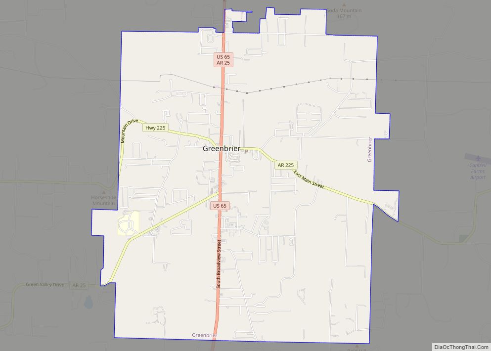
Green Forest is a city in Carroll County, Arkansas, United States. The population was 2,972 at the 2020 census. Green Forest city overview: Name: Green Forest city LSAD Code: 25 LSAD Description: city (suffix) State: Arkansas County: Carroll County Elevation: 1,339 ft (408 m) Total Area: 2.46 sq mi (6.38 km²) Land Area: 2.46 sq mi (6.38 km²) Water Area: 0.00 sq mi (0.00 km²) Total ... Read more
Map of US Cities and Places
Gravette /ˈɡrævɪt/ is a city in Benton County, Arkansas, United States. The population is 3,547 according to the 2020 census. The population was 3,547 as of the 2020 census. It is part of the Northwest Arkansas region. Gravette city overview: Name: Gravette city LSAD Code: 25 LSAD Description: city (suffix) State: Arkansas County: Benton County ... Read more
Greenwood is a city in and one of the two county seats of Sebastian County, Arkansas, United States. It is the fifth largest municipality in the Fort Smith, Arkansas–Oklahoma Metropolitan Statistical Area with a population of 8,952 according to the 2010 US Census. According to estimates based on the most recent census, the population of ... Read more
Greenway is a city in eastern Clay County, Arkansas, United States. The population was 209 at the 2010 census. Greenway city overview: Name: Greenway city LSAD Code: 25 LSAD Description: city (suffix) State: Arkansas County: Clay County Elevation: 285 ft (87 m) Total Area: 0.26 sq mi (0.67 km²) Land Area: 0.26 sq mi (0.67 km²) Water Area: 0.00 sq mi (0.00 km²) Total Population: 174 ... Read more
Greenland is a city in Washington County, Arkansas, United States. The population is 1,213 as of the 2020 census. The community is located in the Boston Mountains, within the Ozark Mountains. Greenland city overview: Name: Greenland city LSAD Code: 25 LSAD Description: city (suffix) State: Arkansas County: Washington County Elevation: 1,293 ft (394 m) Land Area: 4.01 sq mi ... Read more
Grubbs is a city in Jackson County, Arkansas, United States. The population was 386 at the 2010 census. Grubbs city overview: Name: Grubbs city LSAD Code: 25 LSAD Description: city (suffix) State: Arkansas County: Jackson County Elevation: 230 ft (70 m) Total Area: 0.57 sq mi (1.47 km²) Land Area: 0.57 sq mi (1.47 km²) Water Area: 0.00 sq mi (0.00 km²) Total Population: 301 Population ... Read more
Griffithville is a town in White County, Arkansas, United States. Windle Porter is the current mayor. The population was 262 at the 2000 census. Griffithville town overview: Name: Griffithville town LSAD Code: 43 LSAD Description: town (suffix) State: Arkansas County: White County Elevation: 217 ft (66 m) Total Area: 0.55 sq mi (1.42 km²) Land Area: 0.55 sq mi (1.42 km²) Water Area: ... Read more
Greers Ferry is a city in Cleburne County, Arkansas, United States. The population was 891 at the 2010 census. Greers Ferry city overview: Name: Greers Ferry city LSAD Code: 25 LSAD Description: city (suffix) State: Arkansas County: Cleburne County Elevation: 604 ft (184 m) Total Area: 7.23 sq mi (18.72 km²) Land Area: 7.22 sq mi (18.69 km²) Water Area: 0.01 sq mi (0.03 km²) Total ... Read more
Gurdon is a city in Clark County, Arkansas, United States. The population was 2,212 at the 2010 census. Gurdon city overview: Name: Gurdon city LSAD Code: 25 LSAD Description: city (suffix) State: Arkansas County: Clark County Elevation: 203 ft (62 m) Total Area: 2.49 sq mi (6.46 km²) Land Area: 2.42 sq mi (6.28 km²) Water Area: 0.07 sq mi (0.18 km²) Total Population: 1,840 Population ... Read more
Gum Springs is a town in Clark County, Arkansas, United States. The population was 120 at the 2010 census, down from 194 in 2000. Gum Springs town overview: Name: Gum Springs town LSAD Code: 43 LSAD Description: town (suffix) State: Arkansas County: Clark County Elevation: 210 ft (60 m) Total Area: 0.39 sq mi (1.01 km²) Land Area: 0.39 sq mi (1.01 km²) ... Read more
Guion is a town in Izard County, Arkansas, United States. The population was 86 at the 2010 census. Guion town overview: Name: Guion town LSAD Code: 43 LSAD Description: town (suffix) State: Arkansas County: Izard County Elevation: 371 ft (113 m) Total Area: 0.56 sq mi (1.45 km²) Land Area: 0.56 sq mi (1.45 km²) Water Area: 0.00 sq mi (0.00 km²) Total Population: 68 Population ... Read more
Hagarville is a census-designated place in Johnson County, Arkansas, United States. Per the 2020 census, the population was 142. Hagarville CDP overview: Name: Hagarville CDP LSAD Code: 57 LSAD Description: CDP (suffix) State: Arkansas County: Johnson County Elevation: 535 ft (163 m) Total Area: 4.16 sq mi (10.79 km²) Land Area: 4.14 sq mi (10.73 km²) Water Area: 0.02 sq mi (0.05 km²) Total Population: 142 ... Read more