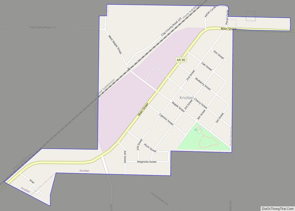
Map of Kirby CDP, Arkansas
Kirby is an unincorporated census-designated place in northern Pike County, Arkansas, United States. The community lies on U.S. Route 70; it is located halfway between Daisy and Glenwood. Per the 2020 census, the population was 721. Kirby CDP overview: Name: Kirby CDP LSAD Code: 57 LSAD Description: CDP (suffix) State: Arkansas County: Pike County Elevation: ... Read more
Map of Kirby CDP, Arkansas
Map of Kingsland city, Arkansas
Kingsland is a town in Cleveland County, south central Arkansas, United States. It is included in the Pine Bluff, Arkansas Metropolitan Statistical Area, and had a population of 447 at the 2010 U.S. census. It is known as the birthplace of musician Johnny Cash. His parents had a cotton farm there. Kingsland city overview: Name: ... Read more
Map of Kingsland city, Arkansas
Map of LaGrange town, Arkansas
LaGrange is a town in Lee County, Arkansas, United States. The population was 89 at the 2010 census, down from 122 at the 2000 census. LaGrange town overview: Name: LaGrange town LSAD Code: 43 LSAD Description: town (suffix) State: Arkansas County: Lee County Elevation: 217 ft (66 m) Total Area: 0.15 sq mi (0.39 km²) Land Area: 0.15 sq mi (0.39 km²) Water ... Read more
Map of LaGrange town, Arkansas
Map of Lafe town
Lafe is a town in Greene County, Arkansas, United States on Crowley’s Ridge. The population was 448 at the 2010 census, up from 385 in 2000. Lafe town overview: Name: Lafe town LSAD Code: 43 LSAD Description: town (suffix) State: Arkansas County: Greene County Elevation: 335 ft (102 m) Total Area: 2.03 sq mi (5.26 km²) Land Area: 2.03 sq mi (5.26 km²) ... Read more
Map of Lafe town
Map of Knoxville town, Arkansas
Knoxville is a city in Johnson County, Arkansas, United States. The population was 731 at the 2010 census. Knoxville town overview: Name: Knoxville town LSAD Code: 43 LSAD Description: town (suffix) State: Arkansas County: Johnson County Elevation: 387 ft (118 m) Total Area: 3.19 sq mi (8.27 km²) Land Area: 3.18 sq mi (8.25 km²) Water Area: 0.01 sq mi (0.02 km²) Total Population: 660 Population ... Read more
Map of Knoxville town, Arkansas
Map of Lake View city, Arkansas
Lake View is a city in Phillips County, Arkansas, United States. The population was 443 at the 2010 census. Because there is also a Lakeview in Baxter County, many residents want to rename Lakeview to “Lake Helena”. The original settlement name was “Turkey Scratch” from the 1850s to the official declaration of the town’s namesake ... Read more
Map of Lake View city, Arkansas
Map of Lake Hamilton CDP, Arkansas
Lake Hamilton is a census-designated place (CDP) in Garland County, Arkansas, United States. It is part of the Hot Springs Metropolitan Statistical Area. The population was 2,135 at the 2010 census. It is named after Lake Hamilton, one of the area’s man-made lakes. Lake Hamilton CDP overview: Name: Lake Hamilton CDP LSAD Code: 57 LSAD ... Read more
Map of Lake Hamilton CDP, Arkansas
Map of Lake City, Arkansas
Lake City is a city in Craighead County, Arkansas, United States, along the St. Francis River. Lake City is one of two county seats in Craighead County. The population was 2,326 as of the 2020 census. It is included in the Jonesboro, Arkansas Metropolitan Statistical Area. Lake City city overview: Name: Lake City city LSAD ... Read more
Map of Lake City, Arkansas
Map of Lamar city, Arkansas
Lamar is a city in Johnson County, Arkansas, United States. The population was 1,605 at the 2010 census, up from 1,415 at the 2000 census. Lamar city overview: Name: Lamar city LSAD Code: 25 LSAD Description: city (suffix) State: Arkansas County: Johnson County Elevation: 430 ft (130 m) Total Area: 4.64 sq mi (12.03 km²) Land Area: 4.62 sq mi (11.95 km²) Water ... Read more
Map of Lamar city, Arkansas
Map of Lakeview city, Arkansas
Lakeview is a city in Baxter County, Arkansas, United States. The population was 741 at the 2010 census. Lakeview city overview: Name: Lakeview city LSAD Code: 25 LSAD Description: city (suffix) State: Arkansas County: Baxter County Elevation: 787 ft (240 m) Total Area: 1.04 sq mi (2.69 km²) Land Area: 1.04 sq mi (2.69 km²) Water Area: 0.00 sq mi (0.00 km²) Total Population: 775 Population ... Read more
Map of Lakeview city, Arkansas
Map of Lake Village city, Arkansas
Lake Village is a city in and the county seat of Chicot County, Arkansas, United States. The population was 2,575 at the 2010 census. It is located in the Arkansas Delta. Lake Village is named for its location on Lake Chicot, an oxbow lake formed by the Mississippi River. Lake Village city overview: Name: Lake ... Read more
Map of Lake Village city, Arkansas
Map of Leachville city
Leachville is a city in Mississippi County, Arkansas, United States. The population was 2,039 at the 2020 census. Leachville was incorporated in 1916. Leachville city overview: Name: Leachville city LSAD Code: 25 LSAD Description: city (suffix) State: Arkansas County: Mississippi County Elevation: 233 ft (71 m) Total Area: 4.40 sq mi (11.40 km²) Land Area: 4.40 sq mi (11.40 km²) Water Area: 0.00 sq mi ... Read more
Map of Leachville city