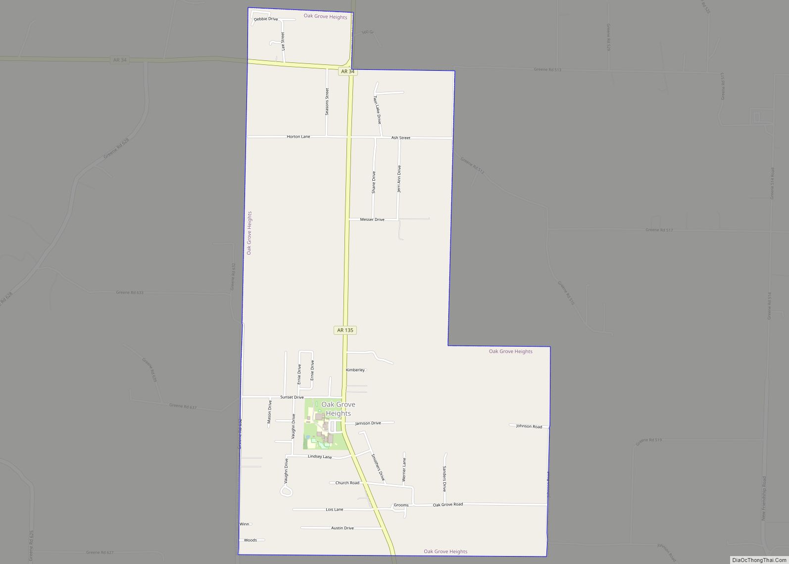
Map of O’Kean town
O’Kean is a town in Randolph County, Arkansas, United States. The population was 192 at the 2020 census. O’Kean town overview: Name: O’Kean town LSAD Code: 43 LSAD Description: town (suffix) State: Arkansas County: Randolph County Elevation: 269 ft (82 m) Total Area: 1.02 sq mi (2.64 km²) Land Area: 1.02 sq mi (2.64 km²) Water Area: 0.00 sq mi (0.00 km²) Total Population: 192 Population ... Read more
Map of O’Kean town
Map of North Little Rock city
North Little Rock is a city in Pulaski County, Arkansas, across the Arkansas River from Little Rock in the central part of the state. The population was 64,591 at the 2020 census. In 2019 the estimated population was 65,903, making it the seventh-most populous city in the state. North Little Rock, along with Little Rock ... Read more
Map of North Little Rock city
Map of Oden town, Arkansas
Oden is a town in Montgomery County, Arkansas, United States. As of the 2020 census, its population was 180, down from 232 in 2010. Oden town overview: Name: Oden town LSAD Code: 43 LSAD Description: town (suffix) State: Arkansas County: Montgomery County Elevation: 761 ft (232 m) Total Area: 0.84 sq mi (2.17 km²) Land Area: 0.81 sq mi (2.11 km²) Water Area: ... Read more
Map of Oden town, Arkansas
Map of Oakhaven town
Oakhaven is a town in Hempstead County, Arkansas, United States. The population was 63 at the 2010 census. It is part of the Hope Micropolitan Statistical Area. Oakhaven town overview: Name: Oakhaven town LSAD Code: 43 LSAD Description: town (suffix) State: Arkansas County: Hempstead County Elevation: 367 ft (112 m) Total Area: 0.05 sq mi (0.12 km²) Land Area: 0.05 sq mi ... Read more
Map of Oakhaven town
Map of Oak Grove town, Arkansas
Oak Grove is a town in Carroll County, Arkansas, United States. The population was 386 at the 2020 census. Oak Grove town overview: Name: Oak Grove town LSAD Code: 43 LSAD Description: town (suffix) State: Arkansas County: Carroll County Elevation: 1,352 ft (412 m) Total Area: 2.76 sq mi (7.15 km²) Land Area: 2.76 sq mi (7.15 km²) Water Area: 0.00 sq mi (0.00 km²) Total ... Read more
Map of Oak Grove town, Arkansas
Map of Okolona town, Arkansas
Okolona is a town near the western edge of Clark County, Arkansas, United States. The population was 147 at the 2010 census. The Battle of Elkin’s Ferry of the Civil War was fought here during April 3–4, 1864, as a part of the Camden Expedition. Union forces, led by Maj. Gen. Fred Steele, sought to ... Read more
Map of Okolona town, Arkansas
Map of Oil Trough town
Oil Trough is a town in Independence County, Arkansas, United States. The population was 260 at the 2010 census. The town is believed to have acquired its name in the early 19th century from a trough used to render bear fat, which was sold to customers in New Orleans. Oil Trough town overview: Name: Oil ... Read more
Map of Oil Trough town
Map of Ogden city, Arkansas
Ogden is a city in Little River County, Arkansas, United States. The population was 180 at the 2010 census, down from 214 at the 2000 census. Ogden city overview: Name: Ogden city LSAD Code: 25 LSAD Description: city (suffix) State: Arkansas County: Little River County Elevation: 315 ft (96 m) Total Area: 0.38 sq mi (0.99 km²) Land Area: 0.38 sq mi ... Read more
Map of Ogden city, Arkansas
Map of Oppelo city
Oppelo /ˈɑː.pəˌloʊ/ AH-pə-loh is a city in Conway County, Arkansas, United States. The population was 781 at the 2010 census. Oppelo city overview: Name: Oppelo city LSAD Code: 25 LSAD Description: city (suffix) State: Arkansas County: Conway County Elevation: 338 ft (103 m) Total Area: 2.48 sq mi (6.43 km²) Land Area: 2.43 sq mi (6.29 km²) Water Area: 0.05 sq mi (0.13 km²) Total Population: ... Read more
Map of Oppelo city
Map of Omaha town, Arkansas
Omaha is a town in Boone County, Arkansas, United States. As of the 2020 census the population stood at 128. It is a rural community located approximately 10 miles from Branson, Missouri and 15 miles from Harrison. The town is part of the Harrison Micropolitan Statistical Area. Omaha town overview: Name: Omaha town LSAD Code: ... Read more
Map of Omaha town, Arkansas
Map of Ola city, Arkansas
Ola is a city in Yell County, Arkansas, United States. The population was 1,281 at the 2010 census. It is part of the Russellville Micropolitan Statistical Area. As of 2004 it serves as a commercial center in Yell County. Ola city overview: Name: Ola city LSAD Code: 25 LSAD Description: city (suffix) State: Arkansas County: ... Read more
Map of Ola city, Arkansas
Map of Oxford city, Arkansas
Oxford is a city in Izard County, Arkansas, United States. The population was 670 at the 2010 census. Oxford city overview: Name: Oxford city LSAD Code: 25 LSAD Description: city (suffix) State: Arkansas County: Izard County Elevation: 784 ft (239 m) Total Area: 6.54 sq mi (16.95 km²) Land Area: 6.54 sq mi (16.95 km²) Water Area: 0.00 sq mi (0.00 km²) Total Population: 573 Population ... Read more
Map of Oxford city, Arkansas