Map of Coldwater village, Ohio
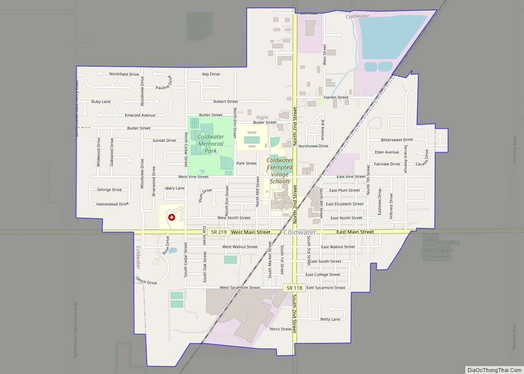
Coldwater is a village in Mercer County, Ohio, United States. The population was 4,427 at the 2010 census. Coldwater village overview: Name: Coldwater village LSAD Code: 47 LSAD Description: village (suffix) State: Ohio County: Mercer County Elevation: 909 ft (277 m) Total Area: 1.99 sq mi (5.16 km²) Land Area: 1.94 sq mi (5.02 km²) Water Area: 0.05 sq mi (0.13 km²) Total Population: 4,774 Population ... Read more
Map of Coldwater village, Ohio
Map of Coldstream CDP, Ohio
Coldstream is a census-designated place (CDP) in southern Anderson Township, Hamilton County, Ohio, United States. The population was 1,322 at the 2020 census. Coldstream CDP overview: Name: Coldstream CDP LSAD Code: 57 LSAD Description: CDP (suffix) State: Ohio County: Hamilton County Elevation: 822 ft (251 m) Total Area: 2.87 sq mi (7.42 km²) Land Area: 2.79 sq mi (7.21 km²) Water Area: 0.08 sq mi ... Read more
Map of Coldstream CDP, Ohio
Map of Coalton village, Ohio
Coalton is a village in Jackson County, Ohio, United States. The population was 479 at the 2010 census. The village derives its name from Coal Township. Coalton village overview: Name: Coalton village LSAD Code: 47 LSAD Description: village (suffix) State: Ohio County: Jackson County Elevation: 692 ft (211 m) Total Area: 0.56 sq mi (1.44 km²) Land Area: 0.56 sq mi (1.44 km²) ... Read more
Map of Coalton village, Ohio
Map of Coal Grove village
Coal Grove is a village in Lawrence County, Ohio, United States, along the Ohio River. The population was 2,165 at the 2010 census. It borders the city of Ironton and lies across the Ohio River from Ashland, Kentucky. It is linked to Ashland by the Ben Williamson Memorial Bridge and Simeon Willis Memorial Bridge. Coal ... Read more
Map of Coal Grove village
Map of Clyde city, Ohio
Clyde /ˈklaɪd/ is a city in Sandusky County, Ohio, located eight miles southeast of Fremont. The population was 6,325 at the time of the 2010 census. The National Arbor Day Foundation has designated Clyde as a Tree City USA. The town is known for having served as inspiration for the setting of Sherwood Anderson’s 1919 ... Read more
Map of Clyde city, Ohio
Map of Cloverdale village, Ohio
Cloverdale is a village in Perry Township, Putnam County, Ohio, United States. The population was 168 at the 2010 census. Cloverdale village overview: Name: Cloverdale village LSAD Code: 47 LSAD Description: village (suffix) State: Ohio County: Putnam County Elevation: 719 ft (219 m) Total Area: 0.62 sq mi (1.61 km²) Land Area: 0.62 sq mi (1.60 km²) Water Area: 0.01 sq mi (0.02 km²) Total Population: ... Read more
Map of Cloverdale village, Ohio
Map of Columbus Grove village
Columbus Grove is a village in Putnam County, Ohio, United States. The population was 2,137 at the 2010 census. Columbus Grove village overview: Name: Columbus Grove village LSAD Code: 47 LSAD Description: village (suffix) State: Ohio County: Putnam County Elevation: 774 ft (236 m) Total Area: 1.23 sq mi (3.20 km²) Land Area: 1.23 sq mi (3.18 km²) Water Area: 0.01 sq mi (0.02 km²) Total ... Read more
Map of Columbus Grove village
Map of Columbiana city, Ohio
Columbiana is a city in northern Columbiana and southern Mahoning counties in the U.S. state of Ohio. The population was 6,559 at the 2020 census. It is part of the Salem micropolitan area and the Youngstown–Warren metropolitan area. The city hosts the annual Shaker Woods Arts & Crafts Festival, which brings national attention to the ... Read more
Map of Columbiana city, Ohio
Map of Collins CDP, Ohio
Collins is a census-designated place (CDP) in central Townsend Township, Huron County, Ohio, United States. As of the 2010 census the population of the CDP was 631. The CDP includes the unincorporated communities of Collins and East Townsend. Collins has a post office, with the ZIP code of 44826. Joshua Hudson is currently serving as ... Read more
Map of Collins CDP, Ohio
Map of College Corner village
College Corner is a village in Butler and Preble counties in the southwestern part of the U.S. state of Ohio, 5 miles (8 km) northwest of Oxford. The population was 387 at the 2020 census. The village lies on the state line with Indiana, where it borders the town of West College Corner. The public school, ... Read more
Map of College Corner village
Map of Corning village, Ohio
Corning is a village in Perry County, Ohio, United States. The population was 488 at the 2020 census. Corning village overview: Name: Corning village LSAD Code: 47 LSAD Description: village (suffix) State: Ohio County: Perry County Elevation: 725 ft (221 m) Total Area: 0.43 sq mi (1.11 km²) Land Area: 0.43 sq mi (1.11 km²) Water Area: 0.00 sq mi (0.00 km²) Total Population: 488 Population ... Read more
Map of Corning village, Ohio
Map of Coolville village
Coolville is a village located in Troy Township, Athens County, Ohio, United States, in the southeast area of the state. The population was 452 at the 2020 census. Coolville village overview: Name: Coolville village LSAD Code: 47 LSAD Description: village (suffix) State: Ohio County: Athens County Elevation: 699 ft (213 m) Total Area: 1.00 sq mi (2.58 km²) Land Area: ... Read more
Map of Coolville village