Map of Holland village, Ohio
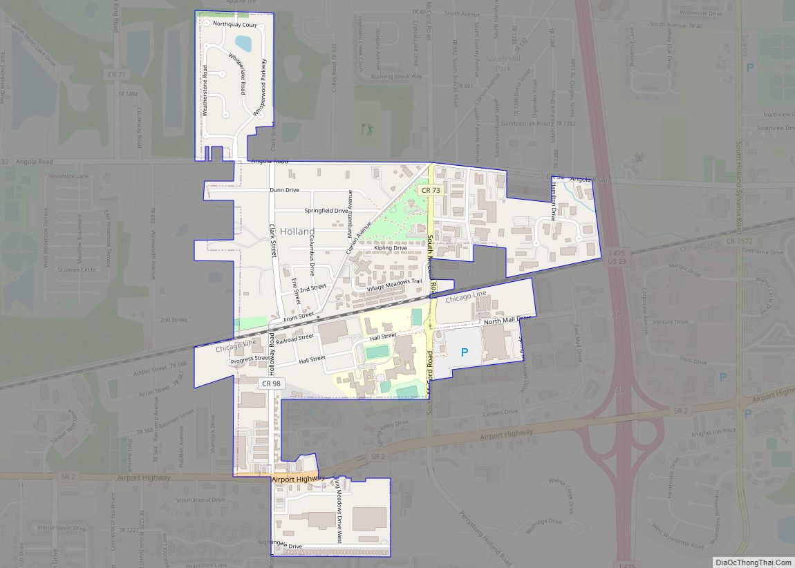
Holland is a village in eastern Springfield Township, Lucas County, Ohio, United States. Holland is a suburb of Toledo. The population was 1,664 at the 2020 census. Holland is home to the J.H. Fentress Antique Popcorn Museum. Holland village overview: Name: Holland village LSAD Code: 47 LSAD Description: village (suffix) State: Ohio County: Lucas County ... Read more
Map of Holland village, Ohio
Map of Holiday Valley CDP
Holiday Valley is a census-designated place (CDP) in Clark County, Ohio, United States. The population was 1,510 at the 2010 census. It is part of the Springfield, Ohio Metropolitan Statistical Area. Holiday Valley CDP overview: Name: Holiday Valley CDP LSAD Code: 57 LSAD Description: CDP (suffix) State: Ohio County: Clark County Elevation: 860 ft (262 m) Total ... Read more
Map of Holiday Valley CDP
Map of Holiday Lakes CDP, Ohio
Holiday Lakes is an unincorporated community and census-designated place in Huron County, Ohio, United States. Its population was 749 as of the 2010 census. Ohio State Route 99 passes through the community. Holiday Lakes CDP overview: Name: Holiday Lakes CDP LSAD Code: 57 LSAD Description: CDP (suffix) State: Ohio County: Huron County Elevation: 833 ft (254 m) ... Read more
Map of Holiday Lakes CDP, Ohio
Map of Holiday City village
Holiday City is a village in Williams County, Ohio, United States. The population was 52 at the 2010 census. Holiday City village overview: Name: Holiday City village LSAD Code: 47 LSAD Description: village (suffix) State: Ohio County: Williams County Elevation: 899 ft (274 m) Total Area: 2.57 sq mi (6.67 km²) Land Area: 2.55 sq mi (6.62 km²) Water Area: 0.02 sq mi (0.05 km²) Total ... Read more
Map of Holiday City village
Map of Holgate village
Holgate is a village in Henry County, Ohio, United States. The population was 1,109 at the 2010 census. Holgate village overview: Name: Holgate village LSAD Code: 47 LSAD Description: village (suffix) State: Ohio County: Henry County Elevation: 712 ft (217 m) Total Area: 1.15 sq mi (2.99 km²) Land Area: 1.15 sq mi (2.99 km²) Water Area: 0.00 sq mi (0.00 km²) Total Population: 1,061 Population ... Read more
Map of Holgate village
Map of Hockingport CDP
Hockingport is a census-designated place in southeastern Troy Township, Athens County, Ohio, United States. As of the 2020 census it had a population of 205. It has a post office with the ZIP code 45739. It is located at the intersection of State Routes 124 and 144. It lies on the Ohio River, located below ... Read more
Map of Hockingport CDP
Map of Hiram village, Ohio
Hiram is a village in northern Portage County, Ohio, United States. It was formed from portions of Hiram Township in the Connecticut Western Reserve. The population was 996 at the 2020 census. Hiram is part of the Akron metropolitan area. It is the home of Hiram College, a small, private liberal arts college. Hiram village ... Read more
Map of Hiram village, Ohio
Map of Hilltop CDP, Ohio
Hilltop is an unincorporated community and census-designated place in central Weathersfield Township, Trumbull County, Ohio, United States. The population was 658 at the 2020 census. It is part of the Youngstown–Warren metropolitan area. Hilltop CDP overview: Name: Hilltop CDP LSAD Code: 57 LSAD Description: CDP (suffix) State: Ohio County: Trumbull County Elevation: 978 ft (298 m) Total ... Read more
Map of Hilltop CDP, Ohio
Map of Hillsboro city, Ohio
Hillsboro is a city in and the county seat of Highland County, Ohio, United States approximately 35 mi (56 km) west of Chillicothe, and 50 miles east of Cincinnati. The population was 6,605 at the 2010 census. Hillsboro city overview: Name: Hillsboro city LSAD Code: 25 LSAD Description: city (suffix) State: Ohio County: Highland County Elevation: 1,122 ft ... Read more
Map of Hillsboro city, Ohio
Map of Hills and Dales village, Ohio
Hills and Dales is a village in Stark County, Ohio, United States. It is an affluent suburban enclave near Canton. Hills and Dales is part of the Canton–Massillon Metropolitan Statistical Area. The population was 221 at the 2010 census. The name Hills and Dales was coined by property developers for the terrain of the town ... Read more
Map of Hills and Dales village, Ohio
Map of Homeworth CDP
Homeworth is an unincorporated community and census-designated place in southwestern Knox Township, Columbiana County, Ohio, United States. The population was 492 as of the 2020 census. It is located in the Salem micropolitan area and the greater Youngstown–Warren area, and has a post office with the ZIP code 44634. Homeworth CDP overview: Name: Homeworth CDP ... Read more
Map of Homeworth CDP
Map of Holmesville village, Ohio
Holmesville is a village in Holmes County, Ohio, United States, along Killbuck Creek. The population was 372 at the 2010 census. Holmesville was platted in 1836, and named for its location with Holmes County. Holmesville village overview: Name: Holmesville village LSAD Code: 47 LSAD Description: village (suffix) State: Ohio County: Holmes County Elevation: 860 ft (262 m) ... Read more
Map of Holmesville village, Ohio