Laura is a village in Miami County, Ohio, United States. The population was 474 at the 2010 census. It is part of the Dayton Metropolitan Statistical Area. Laura village overview: Name: Laura village LSAD Code: 47 LSAD Description: village (suffix) State: Ohio County: Miami County Elevation: 991 ft (302 m) Total Area: 0.27 sq mi (0.69 km²) Land Area: 0.27 sq mi ... Read more
Map of US Cities and Places
Latty is a village in Paulding County, Ohio, United States. The population was 193 at the 2010 census. Latty village overview: Name: Latty village LSAD Code: 47 LSAD Description: village (suffix) State: Ohio County: Paulding County Elevation: 728 ft (222 m) Total Area: 0.27 sq mi (0.70 km²) Land Area: 0.27 sq mi (0.70 km²) Water Area: 0.00 sq mi (0.00 km²) Total Population: 165 Population ... Read more
Lewisburg is a village in Preble County, Ohio, United States, founded in 1818. The current village incorporates two prior villages, the original Lewisburg and Euphemia, which merged in 1916. The population was 1,820 at the 2010 census. It is part of the Dayton Metropolitan Statistical Area. Lewisburg village overview: Name: Lewisburg village LSAD Code: 47 ... Read more
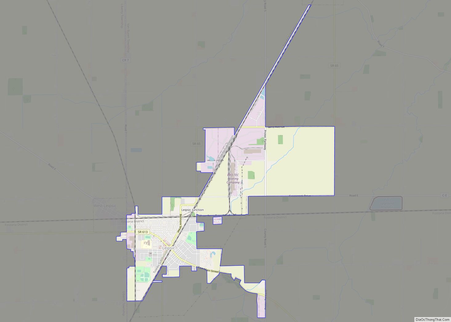
Leipsic /ˈlɪpsɪk/ is a village in Putnam County, Ohio, United States. The population was 2,093 at the 2010 census. Leipsic village overview: Name: Leipsic village LSAD Code: 47 LSAD Description: village (suffix) State: Ohio County: Putnam County Elevation: 764 ft (233 m) Total Area: 3.70 sq mi (9.57 km²) Land Area: 3.68 sq mi (9.54 km²) Water Area: 0.01 sq mi (0.03 km²) Total Population: 2,177 ... Read more
Linndale is the smallest village in Cuyahoga County, Ohio, United States. It is landlocked, surrounded by the city of Cleveland and the suburb of Brooklyn. According to the 2020 census, the population was 108. Linndale village overview: Name: Linndale village LSAD Code: 47 LSAD Description: village (suffix) State: Ohio County: Cuyahoga County Elevation: 755 ft (230 m) ... Read more
Lindsey is a village in Sandusky County, Ohio, United States, near the halfway point of the route between Detroit and Cleveland. The population was 446 at the 2010 census. The National Arbor Day Foundation has designated Lindsey as a Tree City USA. Lindsey village overview: Name: Lindsey village LSAD Code: 47 LSAD Description: village (suffix) ... Read more
Lincoln Village is a census-designated place (CDP) in Prairie Township, Franklin County, Ohio, United States. It is centered near the intersection of US 40 and I-270 on the west side of Columbus. As of the 2010 census, the population was 9,032, down from 9,482 at the 2000 census. Lincoln Village was started in 1955 as ... Read more
Lincoln Heights is a village in Hamilton County, Ohio, United States. The population was 3,144 at the 2020 census. It is a suburb of Cincinnati. Lincoln Heights village overview: Name: Lincoln Heights village LSAD Code: 47 LSAD Description: village (suffix) State: Ohio County: Hamilton County Elevation: 594 ft (181 m) Total Area: 0.74 sq mi (1.92 km²) Land Area: 0.74 sq mi ... Read more
Limaville is a census-designated place (CDP) and former village in Stark County, Ohio, United States. The population was 151 at the 2010 census. It is part of the Canton–Massillon Metropolitan Statistical Area. Limaville village overview: Name: Limaville village LSAD Code: 47 LSAD Description: village (suffix) State: Ohio County: Stark County Elevation: 1,060 ft (323 m) Total Area: ... Read more
Lima (/ˈlaɪmə/ LY-mə) is a city in and the county seat of Allen County, Ohio, United States. The municipality is located in northwest Ohio along Interstate 75 approximately 72 miles (116 km) north of Dayton, 78 miles (126 km) southwest of Toledo, and 63 mi (101 km) southeast of Fort Wayne, Indiana. As of the 2020 census, the city ... Read more
Liberty Center is a village in Henry County, Ohio, United States. The population was 1,180 at the 2010 census. Liberty Center village overview: Name: Liberty Center village LSAD Code: 47 LSAD Description: village (suffix) State: Ohio County: Henry County Elevation: 679 ft (207 m) Total Area: 1.03 sq mi (2.68 km²) Land Area: 1.03 sq mi (2.68 km²) Water Area: 0.00 sq mi (0.00 km²) Total ... Read more
Lexington is a village along the Clear Fork River in Troy Township and Washington Township in Richland County in the U.S. state of Ohio. It is part of the Mansfield, Ohio Metropolitan Statistical Area. The population was 4,822 at the 2010 census, an increase from 4,165 in 2000. The Mid-Ohio Sports Car Course is located ... Read more