Map of McDermott CDP
McDermott is a census-designated place in western Rush Township, Scioto County, Ohio, United States. As of the 2010 census it had a population of 434. It has a post office with the ZIP code 45652. McDermott CDP overview: Name: McDermott CDP LSAD Code: 57 LSAD Description: CDP (suffix) State: Ohio County: Scioto County FIPS code: ... Read more
Map of McDermott CDP
Map of Mentor-on-the-Lake city
Mentor-on-the-Lake is a city in Lake County, Ohio, United States. The population was 7,131 at the 2020 census. Mentor-on-the-Lake city overview: Name: Mentor-on-the-Lake city LSAD Code: 25 LSAD Description: city (suffix) State: Ohio County: Lake County Elevation: 620 ft (189 m) Total Area: 1.65 sq mi (4.28 km²) Land Area: 1.61 sq mi (4.18 km²) Water Area: 0.04 sq mi (0.10 km²) Total Population: 7,131 Population ... Read more
Map of Mentor-on-the-Lake city
Map of Mendon village, Ohio
Mendon is a village in Mercer County, Ohio, United States. The population was 662 at the 2010 census. Mendon village overview: Name: Mendon village LSAD Code: 47 LSAD Description: village (suffix) State: Ohio County: Mercer County Elevation: 820 ft (250 m) Total Area: 0.56 sq mi (1.44 km²) Land Area: 0.55 sq mi (1.41 km²) Water Area: 0.01 sq mi (0.03 km²) Total Population: 628 Population ... Read more
Map of Mendon village, Ohio
Map of Melrose village, Ohio
Melrose is a village in Paulding County, Ohio, United States. The population was 275 at the 2010 census. Melrose village overview: Name: Melrose village LSAD Code: 47 LSAD Description: village (suffix) State: Ohio County: Paulding County Elevation: 709 ft (216 m) Total Area: 0.86 sq mi (2.22 km²) Land Area: 0.86 sq mi (2.22 km²) Water Area: 0.00 sq mi (0.00 km²) Total Population: 233 Population ... Read more
Map of Melrose village, Ohio
Map of Melmore CDP
Melmore is a census-designated place in central Eden Township, Seneca County, Ohio, United States. It has a post office with the ZIP code 44845. It is located at the intersection of State Routes 67 and 100. Melmore CDP overview: Name: Melmore CDP LSAD Code: 57 LSAD Description: CDP (suffix) State: Ohio County: Seneca County Total ... Read more
Map of Melmore CDP
Map of Medina city, Ohio
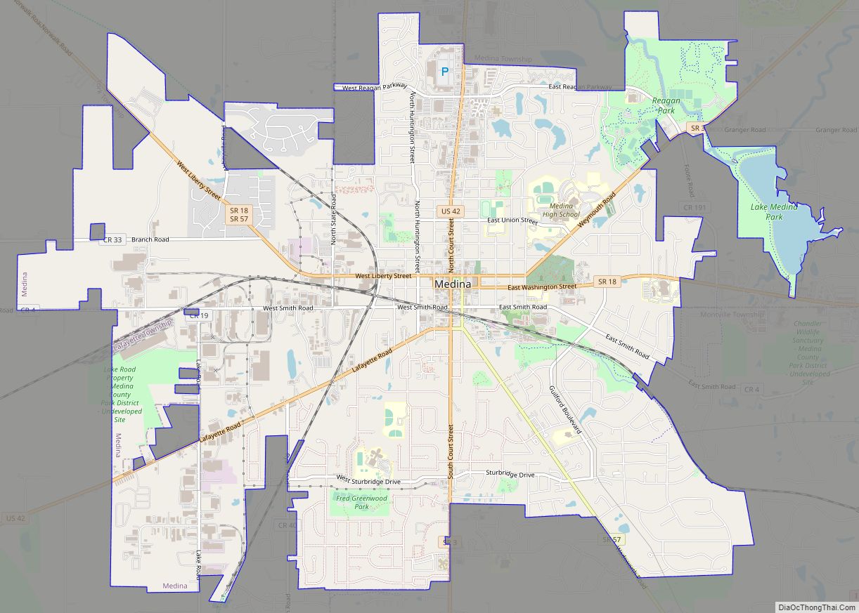
Medina (/mɪˈdaɪnə/ mih-DY-nə) is a city in and the county seat of Medina County, Ohio, United States. The population was 26,094 at the 2020 census. It lies about 33 miles (53 km) south of Cleveland and 23 miles (37 km) west of Akron within the Cleveland metropolitan area. Medina city overview: Name: Medina city LSAD Code: 25 ... Read more
Map of Medina city, Ohio
Map of Mechanicsburg village, Ohio
Mechanicsburg is a village in Champaign County, Ohio, United States. The population was 1,644 at the 2010 census. Mechanicsburg village overview: Name: Mechanicsburg village LSAD Code: 47 LSAD Description: village (suffix) State: Ohio County: Champaign County Elevation: 1,083 ft (330 m) Total Area: 0.98 sq mi (2.55 km²) Land Area: 0.98 sq mi (2.54 km²) Water Area: 0.00 sq mi (0.01 km²) Total Population: 1,681 Population ... Read more
Map of Mechanicsburg village, Ohio
Map of McKinley Heights CDP
McKinley Heights is an unincorporated community and census-designated place in northeastern Weathersfield Township, Trumbull County, Ohio, United States. The population was 950 at the 2020 census. It is part of the Youngstown–Warren metropolitan area. The community is located at the intersection of U.S. Route 422 and Ohio State Route 169. McKinley Heights CDP overview: Name: ... Read more
Map of McKinley Heights CDP
Map of McGuffey village
McGuffey is a village in Hardin County, Ohio, United States. The population was 501 at the 2010 census. McGuffey village overview: Name: McGuffey village LSAD Code: 47 LSAD Description: village (suffix) State: Ohio County: Hardin County Elevation: 971 ft (296 m) Total Area: 0.37 sq mi (0.96 km²) Land Area: 0.37 sq mi (0.96 km²) Water Area: 0.00 sq mi (0.00 km²) Total Population: 466 Population ... Read more
Map of McGuffey village
Map of McDonald village, Ohio
McDonald is a village in southern Trumbull County, Ohio, United States, along the Mahoning River. The population was 3,172 at the 2020 census. It is a suburb of the Youngstown–Warren metropolitan area. McDonald village overview: Name: McDonald village LSAD Code: 47 LSAD Description: village (suffix) State: Ohio County: Trumbull County Elevation: 961 ft (293 m) Total Area: ... Read more
Map of McDonald village, Ohio
Map of Miamiville CDP
Miamiville is an unincorporated community and census-designated place (CDP) in western Miami Township, Clermont County, Ohio, United States, along the Little Miami River and the Loveland Bike Trail. It had a population of 205 at the 2020 census. It has a post office with the ZIP code 45147. Miamiville CDP overview: Name: Miamiville CDP LSAD ... Read more
Map of Miamiville CDP
Map of Miamitown CDP
Miamitown is a census-designated place (CDP) in western Whitewater Township, Hamilton County, Ohio, United States. The population was 1,256 at the 2020 census. It has a post office with the ZIP code 45041. Miamitown CDP overview: Name: Miamitown CDP LSAD Code: 57 LSAD Description: CDP (suffix) State: Ohio County: Hamilton County Elevation: 525 ft (160 m) Total ... Read more
Map of Miamitown CDP