Map of Sherrodsville village
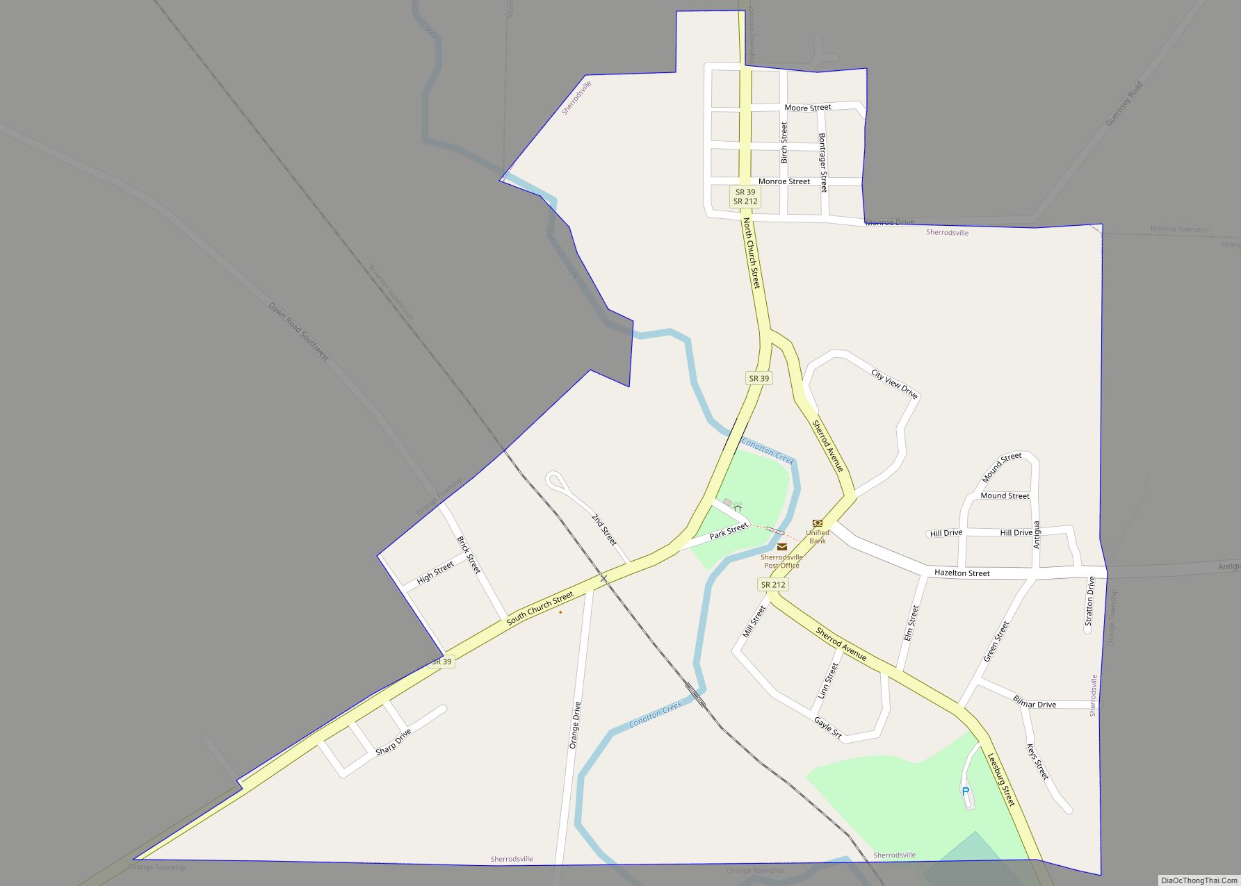
Sherrodsville (/ˈʃɛrɒdzvɪl/ SHERR-odz-vil) is a village in southwestern Carroll County, Ohio, United States. The population was 222 at the 2020 census. It is part of the Canton–Massillon metropolitan area. Sherrodsville village overview: Name: Sherrodsville village LSAD Code: 47 LSAD Description: village (suffix) State: Ohio County: Carroll County Elevation: 909 ft (277 m) Total Area: 0.32 sq mi (0.82 km²) Land ... Read more
Map of Sherrodsville village
Map of Shelby city, Ohio
Shelby is a city in Richland County in the U.S. state of Ohio, northwest of the city of Mansfield. It is part of the Mansfield, Ohio Metropolitan Statistical Area. The population was 9,317 as of the 2010 census. Shelby city overview: Name: Shelby city LSAD Code: 25 LSAD Description: city (suffix) State: Ohio County: Richland ... Read more
Map of Shelby city, Ohio
Map of Sheffield village, Ohio
Sheffield is a village in Lorain County, Ohio, United States, along the Black River. The population was 4,135 at the 2020 census. It is part of the Cleveland metropolitan area. Sheffield village overview: Name: Sheffield village LSAD Code: 47 LSAD Description: village (suffix) State: Ohio County: Lorain County Elevation: 633 ft (193 m) Total Area: 10.84 sq mi (28.08 km²) ... Read more
Map of Sheffield village, Ohio
Map of Sheffield Lake city
Sheffield Lake is a city in Lorain County, Ohio, United States. The population was 8,957 at the 2020 census. It is part of the Cleveland metropolitan area. Sheffield Lake city overview: Name: Sheffield Lake city LSAD Code: 25 LSAD Description: city (suffix) State: Ohio County: Lorain County Elevation: 600 ft (183 m) Total Area: 2.49 sq mi (6.46 km²) Land ... Read more
Map of Sheffield Lake city
Map of Solon city, Ohio
Solon (/ˈsoʊlən/ SOH-lun) is a city in southeastern Cuyahoga County, Ohio, United States. A suburb of Cleveland, it is part of the Cleveland metropolitan area. According to the 2020 census, the population of Solon was 24,262. The city has been recognized by Money in its list of “Best Places to Live”, placing 23rd in 2009, ... Read more
Map of Solon city, Ohio
Map of Smithville village, Ohio
Smithville is a village in Wayne County, Ohio, United States. The population was 1,252 at the time of the 2010 census. The village derives its name from Thomas Smith, a pioneer settler. Smithville village overview: Name: Smithville village LSAD Code: 47 LSAD Description: village (suffix) State: Ohio County: Wayne County Elevation: 1,063 ft (324 m) Total Area: ... Read more
Map of Smithville village, Ohio
Map of Smithfield village, Ohio
Smithfield village overview: Name: Smithfield village LSAD Code: 47 LSAD Description: village (suffix) State: Ohio County: Jefferson County FIPS code: 3972760 Online Interactive Map Smithfield online map. Source: Basemap layers from Google Map, Open Street Map (OSM), Arcgisonline, Wmflabs. Boundary Data from Database of Global Administrative Areas. Smithfield location map. Where is Smithfield village? Smithfield ... Read more
Map of Smithfield village, Ohio
Map of Skyline Acres CDP
Skyline Acres is a census-designated place (CDP) in Colerain and Springfield townships, Hamilton County, Ohio, United States. The population was 1,446 at the 2020 census. Skyline Acres CDP overview: Name: Skyline Acres CDP LSAD Code: 57 LSAD Description: CDP (suffix) State: Ohio County: Hamilton County Elevation: 840 ft (260 m) Total Area: 0.60 sq mi (1.55 km²) Land Area: 0.59 sq mi ... Read more
Map of Skyline Acres CDP
Map of Sixteen Mile Stand CDP
Sixteen Mile Stand is a census-designated place (CDP) in Symmes Township, Hamilton County, Ohio, United States, 19 miles (31 km) northeast of downtown Cincinnati. The population of Sixteen Mile Stand was 3,091 at the 2020 census. Sixteen Mile Stand CDP overview: Name: Sixteen Mile Stand CDP LSAD Code: 57 LSAD Description: CDP (suffix) State: Ohio County: ... Read more
Map of Sixteen Mile Stand CDP
Map of Sinking Spring village, Ohio
Sinking Spring is a village in Highland County, Ohio, United States. The population was 133 at the 2010 census. Sinking Spring village overview: Name: Sinking Spring village LSAD Code: 47 LSAD Description: village (suffix) State: Ohio County: Highland County Elevation: 866 ft (264 m) Total Area: 0.47 sq mi (1.21 km²) Land Area: 0.47 sq mi (1.21 km²) Water Area: 0.00 sq mi (0.00 km²) Total ... Read more
Map of Sinking Spring village, Ohio
Map of Silverton village, Ohio
Silverton is a village in Hamilton County, Ohio, United States. The village was formed out of Columbia and Sycamore townships, but withdrew from both and formed a paper township. The population was 4,908 at the 2020 census. Silverton village overview: Name: Silverton village LSAD Code: 47 LSAD Description: village (suffix) State: Ohio County: Hamilton County ... Read more
Map of Silverton village, Ohio
Map of South Amherst village, Ohio
South Amherst is a village in Lorain County, Ohio, United States. The population was 1,581 at the 2020 census. South Amherst village overview: Name: South Amherst village LSAD Code: 47 LSAD Description: village (suffix) State: Ohio County: Lorain County Elevation: 794 ft (242 m) Total Area: 2.43 sq mi (6.28 km²) Land Area: 2.41 sq mi (6.23 km²) Water Area: 0.02 sq mi (0.05 km²) Total ... Read more
Map of South Amherst village, Ohio