Map of Sharonville city
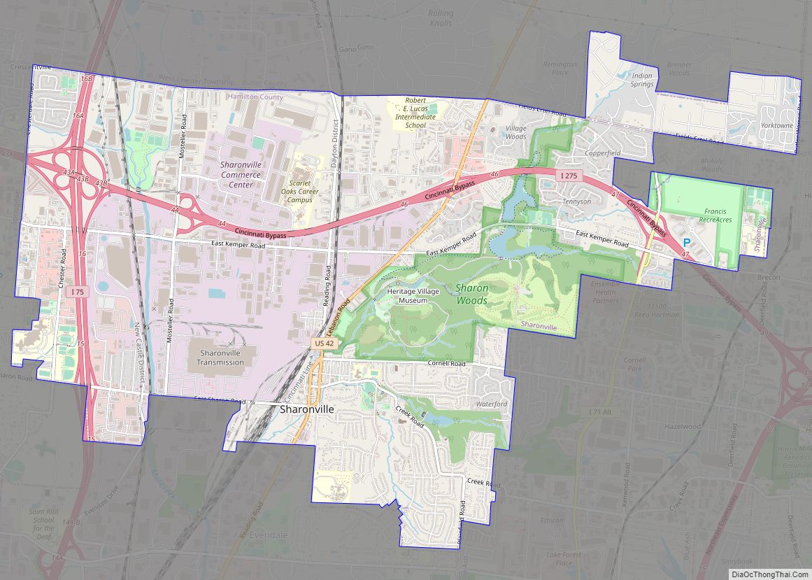
Sharonville is a city largely in Hamilton county in the U.S. state of Ohio. The population was 14,117 at the 2020 census. Sharonville is part of the Cincinnati metropolitan area and located about 13 mi from downtown Cincinnati. Sharonville city overview: Name: Sharonville city LSAD Code: 25 LSAD Description: city (suffix) State: Ohio County: Butler County, ... Read more
Map of Sharonville city
Map of Shaker Heights city
Shaker Heights is a city in Cuyahoga County, Ohio, United States. As of the 2020 census, the city’s population was 29,439. Shaker Heights is an inner-ring streetcar suburb of Cleveland, abutting the eastern edge of the city’s limits. Shaker Heights was a planned community developed by the Van Sweringen brothers, railroad moguls who envisioned the ... Read more
Map of Shaker Heights city
Map of Shadyside village
Shadyside is a village in eastern Belmont County, Ohio, United States, along the Ohio River. The population was 3,454 at the 2020 census. It is part of the Wheeling metropolitan area. Shadyside village overview: Name: Shadyside village LSAD Code: 47 LSAD Description: village (suffix) State: Ohio County: Belmont County Elevation: 689 ft (210 m) Total Area: 1.03 sq mi ... Read more
Map of Shadyside village
Map of Seville village, Ohio
Seville is a village in Medina County, Ohio, United States. The population was 2,296 at the 2010 census. Seville village overview: Name: Seville village LSAD Code: 47 LSAD Description: village (suffix) State: Ohio County: Medina County Elevation: 978 ft (298 m) Total Area: 2.61 sq mi (6.75 km²) Land Area: 2.61 sq mi (6.75 km²) Water Area: 0.00 sq mi (0.00 km²) Total Population: 2,335 Population ... Read more
Map of Seville village, Ohio
Map of Seven Mile village, Ohio
Seven Mile is a village in Butler County, Ohio, United States. The population was 712 at the 2020 census. Seven Mile is served by Edgewood Local School District. Seven Mile Elementary School is the only school located within the village limits. Seven Mile village overview: Name: Seven Mile village LSAD Code: 47 LSAD Description: village ... Read more
Map of Seven Mile village, Ohio
Map of Seven Hills city, Ohio
Seven Hills is a city in Cuyahoga County, Ohio, United States. The population was 11,720 at the 2020 census. Seven Hills city overview: Name: Seven Hills city LSAD Code: 25 LSAD Description: city (suffix) State: Ohio County: Cuyahoga County Elevation: 883 ft (269 m) Total Area: 4.91 sq mi (12.71 km²) Land Area: 4.90 sq mi (12.69 km²) Water Area: 0.01 sq mi (0.02 km²) Total ... Read more
Map of Seven Hills city, Ohio
Map of Sidney city, Ohio
Sidney is a city in Shelby County, Ohio, located approximately 36 mi (58 km) north of Dayton and 100 mi (161 km) south of Toledo. The population was 20,421 at the time of the 2020 census. It is named after English poet Philip Sidney and is the county seat of Shelby County. Many of the city’s elementary schools are ... Read more
Map of Sidney city, Ohio
Map of Shreve village
Shreve is a village in Clinton Township, Wayne County, Ohio, United States. The population was 1,514 at the 2010 census. Shreve is served by a branch of the Wayne County Public Library. Shreve village overview: Name: Shreve village LSAD Code: 47 LSAD Description: village (suffix) State: Ohio County: Wayne County Elevation: 902 ft (275 m) Total Area: ... Read more
Map of Shreve village
Map of Shiloh village, Ohio
Shiloh is a village in Richland County in the U.S. state of Ohio. It is part of the Mansfield, Ohio Metropolitan Statistical Area. The population was 649 at the 2010 census. Shiloh village overview: Name: Shiloh village LSAD Code: 47 LSAD Description: village (suffix) State: Ohio County: Richland County Founded: 1852 Incorporated: 1874 (village) Elevation: ... Read more
Map of Shiloh village, Ohio
Map of Sherwood CDP, Ohio
Sherwood is a census-designated place (CDP) in Hamilton County, Ohio, United States. The population was 3,633 at the 2020 census. Sherwood CDP overview: Name: Sherwood CDP LSAD Code: 57 LSAD Description: CDP (suffix) State: Ohio County: Hamilton County Total Area: 1.1 sq mi (2.9 km²) Land Area: 1.1 sq mi (2.9 km²) Water Area: 0.0 sq mi (0.0 km²) Total Population: 3,633 FIPS code: ... Read more
Map of Sherwood CDP, Ohio
Map of Sherrodsville village
Sherrodsville (/ˈʃɛrɒdzvɪl/ SHERR-odz-vil) is a village in southwestern Carroll County, Ohio, United States. The population was 222 at the 2020 census. It is part of the Canton–Massillon metropolitan area. Sherrodsville village overview: Name: Sherrodsville village LSAD Code: 47 LSAD Description: village (suffix) State: Ohio County: Carroll County Elevation: 909 ft (277 m) Total Area: 0.32 sq mi (0.82 km²) Land ... Read more
Map of Sherrodsville village
Map of Shelby city, Ohio
Shelby is a city in Richland County in the U.S. state of Ohio, northwest of the city of Mansfield. It is part of the Mansfield, Ohio Metropolitan Statistical Area. The population was 9,317 as of the 2010 census. Shelby city overview: Name: Shelby city LSAD Code: 25 LSAD Description: city (suffix) State: Ohio County: Richland ... Read more
Map of Shelby city, Ohio