Map of Tedrow CDP
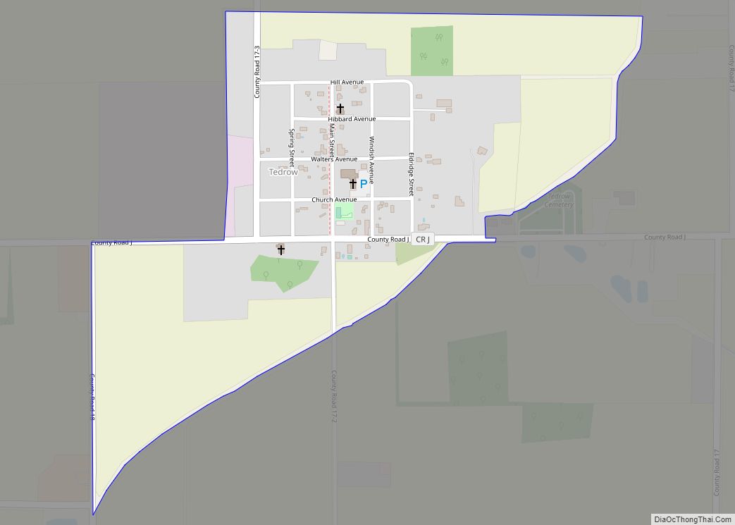
Tedrow is an unincorporated community and census-designated place (CDP) in southwestern Dover Township, Fulton County, Ohio, United States. It lies at the intersection of the east-west County Road J with the north-south County Roads 17-2 and 17-3, 3 miles (5 km) north and 3.5 miles (5.6 km) west of the northern edge of the city of Wauseon, ... Read more
Map of Tedrow CDP
Map of Taylor Creek CDP, Ohio
Taylor Creek is a census-designated place (CDP) in Colerain Township, Hamilton County, Ohio, United States. The population was 4,056 at the 2020 census. Taylor Creek CDP overview: Name: Taylor Creek CDP LSAD Code: 57 LSAD Description: CDP (suffix) State: Ohio County: Hamilton County Elevation: 790 ft (240 m) Total Area: 8.74 sq mi (22.63 km²) Land Area: 8.57 sq mi (22.20 km²) Water ... Read more
Map of Taylor Creek CDP, Ohio
Map of Tippecanoe CDP
Tippecanoe is an unincorporated community and census-designated place (CDP) in central Washington Township, Harrison County, Ohio, United States. It is located along State Route 800 in the valley of Stillwater Creek, a north-flowing tributary of the Tuscarawas River. it had a post office until 2011 with the ZIP code 44699. The population was 121 at ... Read more
Map of Tippecanoe CDP
Map of Tipp City
Tipp City is a city in Miami County, Ohio, United States, just outside Dayton. The population was 9,689 at the 2010 census. Originally known as Tippecanoe, and then Tippecanoe City, it was renamed to Tipp City in 1938 because another town in Ohio was likewise named Tippecanoe. The city lies in the Miami Valley and ... Read more
Map of Tipp City
Map of Timberlake village, Ohio
Timberlake is a village in Lake County, Ohio, United States. The population was 629 at the 2020 census. Timberlake village overview: Name: Timberlake village LSAD Code: 47 LSAD Description: village (suffix) State: Ohio County: Lake County Incorporated: 1947 Elevation: 620 ft (189 m) Total Area: 0.21 sq mi (0.55 km²) Land Area: 0.21 sq mi (0.55 km²) Water Area: 0.00 sq mi (0.00 km²) Total Population: ... Read more
Map of Timberlake village, Ohio
Map of Tiltonsville village
Tiltonsville is a village in southern Jefferson County, Ohio, United States, along the Ohio River. The population was 1,259 at the 2020 census. It is a part of the Weirton–Steubenville metropolitan area. Tiltonsville village overview: Name: Tiltonsville village LSAD Code: 47 LSAD Description: village (suffix) State: Ohio County: Jefferson County Elevation: 669 ft (204 m) Total Area: ... Read more
Map of Tiltonsville village
Map of Tiffin city, Ohio
Tiffin is a city in and the county seat of Seneca County, Ohio, United States. Developed along the Sandusky River, which flows to Lake Erie, Tiffin is about 55 miles southeast of Toledo. The population was 17,963 at the 2010 census. The National Arbor Day Foundation has designated Tiffin as a Tree City USA. It ... Read more
Map of Tiffin city, Ohio
Map of Thurston village, Ohio
Thurston is a village in Fairfield County, Ohio, United States. The population was 604 at the 2010 census. Thurston village overview: Name: Thurston village LSAD Code: 47 LSAD Description: village (suffix) State: Ohio County: Fairfield County Elevation: 883 ft (269 m) Total Area: 0.40 sq mi (1.05 km²) Land Area: 0.40 sq mi (1.05 km²) Water Area: 0.00 sq mi (0.00 km²) Total Population: 603 Population ... Read more
Map of Thurston village, Ohio
Map of Thornville village
Thornville is a village in Perry County, Ohio, United States. It is 20 miles (32 km) north of the county seat of New Lexington. The village had a population of 1,087 as of the 2020 census. Thornville village overview: Name: Thornville village LSAD Code: 47 LSAD Description: village (suffix) State: Ohio County: Perry County Elevation: 1,030 ft ... Read more
Map of Thornville village
Map of Thornport CDP
Thornport is a census-designated place in Perry County, in the U.S. state of Ohio. It is 2 miles north of Thornville and 22 miles north of the county seat of New Lexington. Thornport CDP overview: Name: Thornport CDP LSAD Code: 57 LSAD Description: CDP (suffix) State: Ohio County: Perry County FIPS code: 3976666 Online Interactive ... Read more
Map of Thornport CDP
Map of The Village of Indian Hill city
The Village of Indian Hill is a city in Hamilton County, Ohio, United States, and an affluent suburb of the Greater Cincinnati area. The population was 6,087 at the 2020 census. Prior to 1970, Indian Hill was incorporated as a village, but under Ohio law became designated as a city once its population was verified ... Read more
Map of The Village of Indian Hill city
Map of The Plains CDP, Ohio
The Plains is a census-designated place (CDP) in Athens County, Ohio, United States. The population was 3,140 at the 2020 census. The Plains CDP overview: Name: The Plains CDP LSAD Code: 57 LSAD Description: CDP (suffix) State: Ohio County: Athens County Elevation: 715 ft (218 m) Total Area: 2.29 sq mi (5.92 km²) Land Area: 2.28 sq mi (5.90 km²) Water Area: 0.01 sq mi ... Read more
Map of The Plains CDP, Ohio