Map of Sugar Grove village, Ohio
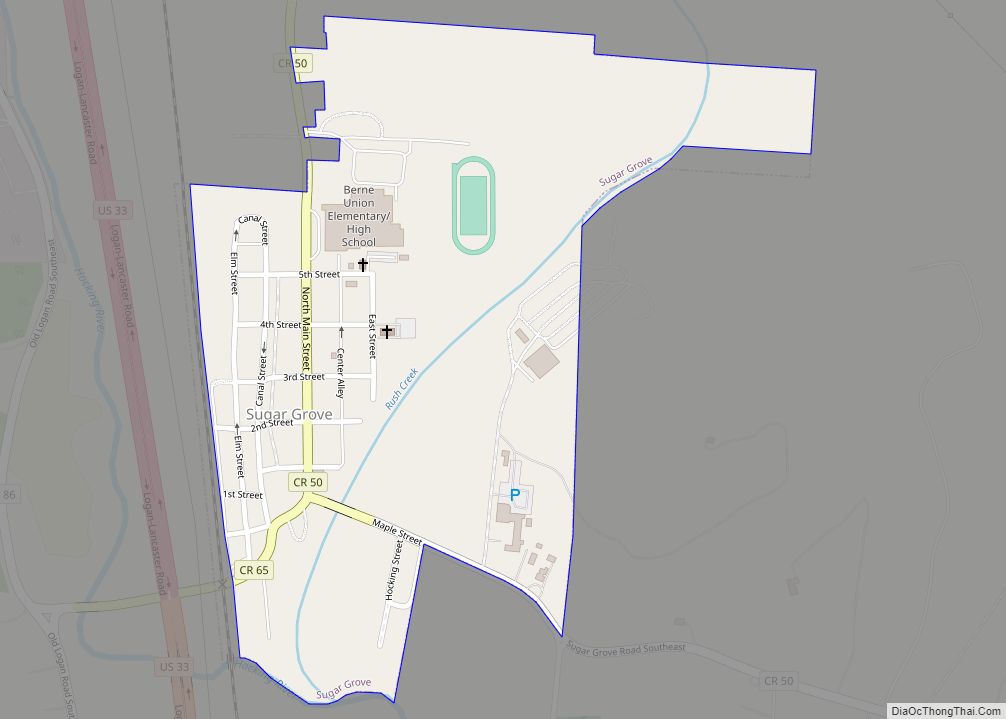
Sugar Grove is a village in Fairfield County, Ohio, United States. The population was 426 at the 2010 census. Sugar Grove village overview: Name: Sugar Grove village LSAD Code: 47 LSAD Description: village (suffix) State: Ohio County: Fairfield County Elevation: 781 ft (238 m) Total Area: 0.32 sq mi (0.83 km²) Land Area: 0.31 sq mi (0.80 km²) Water Area: 0.01 sq mi (0.03 km²) Total ... Read more
Map of Sugar Grove village, Ohio
Map of Sugar Bush Knolls village
Sugar Bush Knolls is a village in western Portage County, Ohio, United States. The population was 217 at the 2020 census. It was formed from portions of Streetsboro and Franklin townships in 1964. The community has the highest median household income in the Akron metropolitan area. Sugar Bush Knolls village overview: Name: Sugar Bush Knolls ... Read more
Map of Sugar Bush Knolls village
Map of Stryker village, Ohio
Stryker is a village in Williams County, Ohio, United States. The population was 1,335 at the 2010 census. Stryker village overview: Name: Stryker village LSAD Code: 47 LSAD Description: village (suffix) State: Ohio County: Williams County Elevation: 712 ft (217 m) Total Area: 0.90 sq mi (2.32 km²) Land Area: 0.90 sq mi (2.32 km²) Water Area: 0.00 sq mi (0.00 km²) Total Population: 1,259 Population ... Read more
Map of Stryker village, Ohio
Map of Struthers city
Struthers is a city in eastern Mahoning County, Ohio, United States, along the Mahoning River. The population was 10,063 at the 2020 census. Located directly southeast of Youngstown, it is a suburb of the Youngstown–Warren metropolitan area. Struthers city overview: Name: Struthers city LSAD Code: 25 LSAD Description: city (suffix) State: Ohio County: Mahoning County ... Read more
Map of Struthers city
Map of Tarlton village
Tarlton is a village in Fairfield and Pickaway counties in the U.S. state of Ohio. The population was 282 at the 2010 census. Tarlton village overview: Name: Tarlton village LSAD Code: 47 LSAD Description: village (suffix) State: Ohio County: Fairfield County, Pickaway County Elevation: 902 ft (275 m) Total Area: 0.38 sq mi (0.99 km²) Land Area: 0.38 sq mi (0.99 km²) Water ... Read more
Map of Tarlton village
Map of Tallmadge city
Tallmadge (/ˈtælmɪdʒ/ TAL-mij) is a city in eastern Summit County, Ohio, United States, with a small district in neighboring Portage County. It is a suburb of Akron and part of the Akron metropolitan area. The population was 18,394 at the 2020 census. Tallmadge was founded in 1807 and is the second-oldest city in Summit County, ... Read more
Map of Tallmadge city
Map of Syracuse village, Ohio
Syracuse is a village in Meigs County, Ohio, United States, along the Ohio River. The population was 781 at the 2020 census. Syracuse village overview: Name: Syracuse village LSAD Code: 47 LSAD Description: village (suffix) State: Ohio County: Meigs County Elevation: 587 ft (179 m) Total Area: 0.90 sq mi (2.34 km²) Land Area: 0.88 sq mi (2.28 km²) Water Area: 0.02 sq mi (0.06 km²) ... Read more
Map of Syracuse village, Ohio
Map of Sylvania city, Ohio
Sylvania is a city in Lucas County, Ohio, United States. The population was 19,011 at the 2020 census. Sylvania is a suburb of Toledo, and encompassed by Sylvania Township. Its northern border is the southern border of the state of Michigan. The name “Sylvania” is borrowed from the Latin sylvan or sylva, meaning “forest land”, ... Read more
Map of Sylvania city, Ohio
Map of Sycamore village, Ohio
Sycamore is a village in Wyandot County, Ohio, United States. The population was 861 at the 2010 census. Sycamore village overview: Name: Sycamore village LSAD Code: 47 LSAD Description: village (suffix) State: Ohio County: Wyandot County Elevation: 850 ft (259 m) Total Area: 0.64 sq mi (1.65 km²) Land Area: 0.64 sq mi (1.65 km²) Water Area: 0.00 sq mi (0.00 km²) Total Population: 793 Population ... Read more
Map of Sycamore village, Ohio
Map of Swanton village, Ohio
Swanton is a village located in Fulton and Lucas counties in the U.S. state of Ohio. The population was 3,897 at the 2020 census. Total area is 8.90 km (3.44 sq mi). Swanton village overview: Name: Swanton village LSAD Code: 47 LSAD Description: village (suffix) State: Ohio County: Fulton County, Lucas County Elevation: 682 ft (208 m) ... Read more
Map of Swanton village, Ohio
Map of Sunbury village, Ohio
Sunbury is a city in Delaware County, Ohio, United States. The population was 4,389 during the 2010 census. The city is centered on a New England-styled traditional town square with a historic village hall located in the center of a village green. Located here is a major Showa Corporation factory, which produces automotive parts for ... Read more
Map of Sunbury village, Ohio
Map of Terrace Park village
Terrace Park is a village in Hamilton County, Ohio, and a wealthy suburb of Greater Cincinnati. The population was 2,355 at the 2020 census. Terrace Park village overview: Name: Terrace Park village LSAD Code: 47 LSAD Description: village (suffix) State: Ohio County: Hamilton County Elevation: 561 ft (171 m) Total Area: 1.24 sq mi (3.21 km²) Land Area: 1.19 sq mi (3.07 km²) ... Read more
Map of Terrace Park village