Map of West Mansfield village
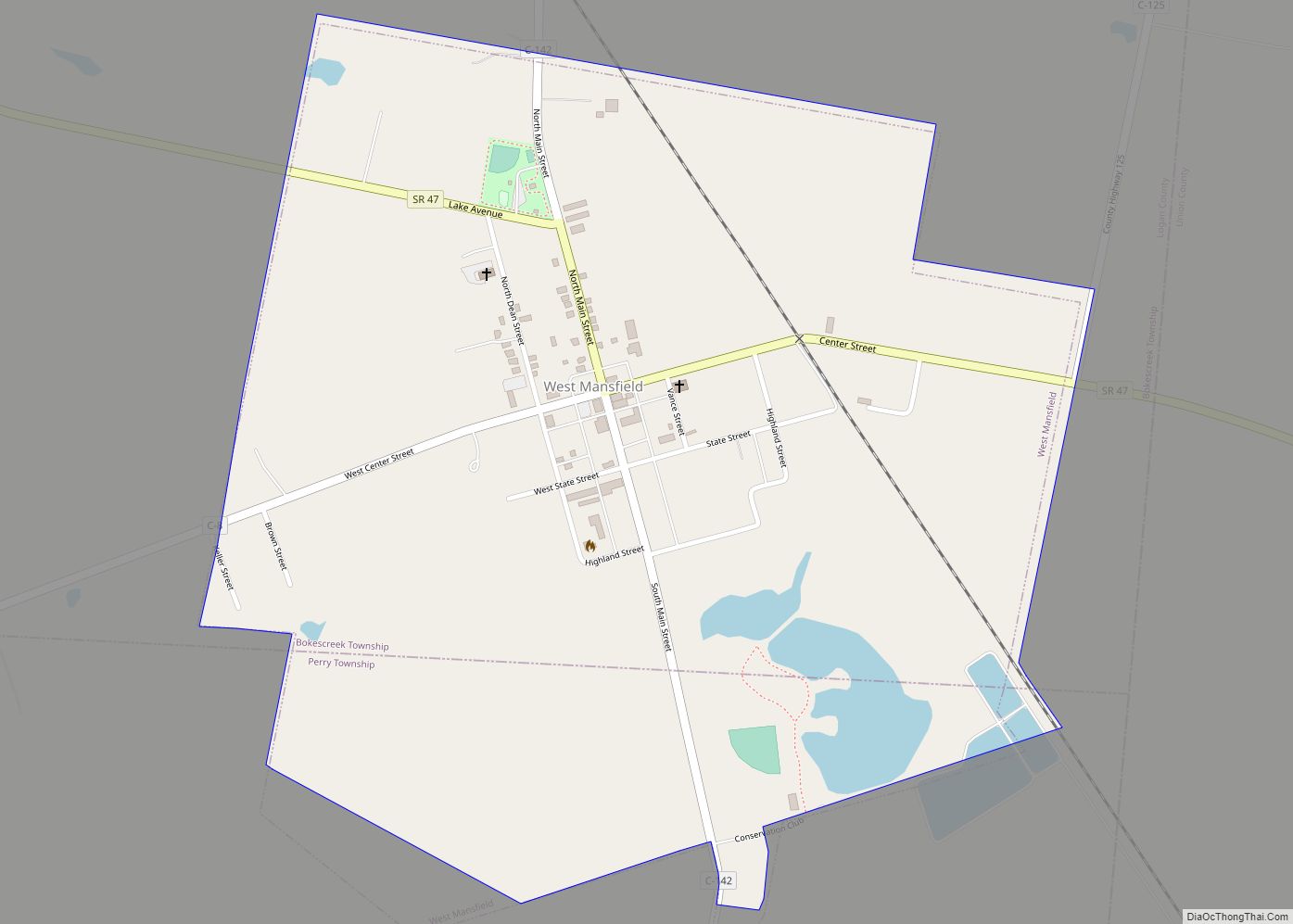
West Mansfield is a village located in Logan County, Ohio, United States. The population was 682 at the 2010 census. A branch of the Logan County District Library serves the West Mansfield community. West Mansfield village overview: Name: West Mansfield village LSAD Code: 47 LSAD Description: village (suffix) State: Ohio County: Logan County Total Area: ... Read more
Map of West Mansfield village
Map of West Manchester village
West Manchester is a village in Preble County, Ohio, United States. The population was 474 at the 2010 census. It is part of the Dayton Metropolitan Statistical Area. West Manchester village overview: Name: West Manchester village LSAD Code: 47 LSAD Description: village (suffix) State: Ohio County: Preble County Total Area: 0.27 sq mi (0.70 km²) Land Area: 0.27 sq mi ... Read more
Map of West Manchester village
Map of West Liberty village, Ohio
West Liberty is a village in Logan County, Ohio, United States. The population was 1,805 at the 2010 census. West Liberty village overview: Name: West Liberty village LSAD Code: 47 LSAD Description: village (suffix) State: Ohio County: Logan County Total Area: 1.22 sq mi (3.15 km²) Land Area: 1.22 sq mi (3.15 km²) Water Area: 0.00 sq mi (0.00 km²) Total Population: 1,770 Population ... Read more
Map of West Liberty village, Ohio
Map of West Leipsic village
West Leipsic is a village in Putnam County, Ohio, United States. The population was 206 at the 2010 census. West Leipsic village overview: Name: West Leipsic village LSAD Code: 47 LSAD Description: village (suffix) State: Ohio County: Putnam County Total Area: 0.25 sq mi (0.65 km²) Land Area: 0.25 sq mi (0.65 km²) Water Area: 0.00 sq mi (0.00 km²) Total Population: 226 Population ... Read more
Map of West Leipsic village
Map of West Lafayette village, Ohio
West Lafayette is a village in Coshocton County, Ohio, United States. The population was 2,321 at the 2010 census. West Lafayette village overview: Name: West Lafayette village LSAD Code: 47 LSAD Description: village (suffix) State: Ohio County: Coshocton County Total Area: 0.86 sq mi (2.23 km²) Land Area: 0.86 sq mi (2.23 km²) Water Area: 0.00 sq mi (0.00 km²) Total Population: 2,417 Population ... Read more
Map of West Lafayette village, Ohio
Map of West Jefferson village, Ohio
West Jefferson is a village in Madison County, Ohio, United States. The population was 4,222 at the 2010 census. Located along U.S. Route 40, the village has a fairly close relationship with the surrounding township, which include various out-of-corporation-limit neighborhoods (including Haymarket Road, Olmstead Road, Forrest Lake Estates, Goodson Road/Enchanted Valley, and North and South ... Read more
Map of West Jefferson village, Ohio
Map of West Hill CDP
West Hill is an unincorporated community and census-designated place in eastern Brookfield Township, Trumbull County, Ohio, United States. The population was 2,218 at the 2020 census. It is part of the Youngstown–Warren metropolitan area. West Hill CDP overview: Name: West Hill CDP LSAD Code: 57 LSAD Description: CDP (suffix) State: Ohio County: Trumbull County Elevation: ... Read more
Map of West Hill CDP
Map of West Farmington village
West Farmington is a village in northwestern Trumbull County, Ohio, United States, along the Grand River. The population was 542 at the 2020 census. It is part of the Youngstown–Warren metropolitan area. West Farmington village overview: Name: West Farmington village LSAD Code: 47 LSAD Description: village (suffix) State: Ohio County: Trumbull County Total Area: 0.90 sq mi ... Read more
Map of West Farmington village
Map of West Salem village, Ohio
West Salem is a village in Wayne County, Ohio. The population was 1,464 at the time of the 2010 census. West Salem is served by a branch of the Wayne County Public Library. The noted drag racing track Dragway 42 is located nearby. West Salem village overview: Name: West Salem village LSAD Code: 47 LSAD ... Read more
Map of West Salem village, Ohio
Map of West Rushville village
West Rushville is a village in Fairfield County, Ohio, United States. The population was 134 at the 2010 census. West Rushville village overview: Name: West Rushville village LSAD Code: 47 LSAD Description: village (suffix) State: Ohio County: Fairfield County Total Area: 0.07 sq mi (0.17 km²) Land Area: 0.07 sq mi (0.17 km²) Water Area: 0.00 sq mi (0.00 km²) Total Population: 166 Population ... Read more
Map of West Rushville village
Map of West Portsmouth CDP
West Portsmouth is a census-designated place (CDP) in Scioto County, Ohio, United States. The population was 3,149 in accordance with the 2010 census. The citizens of West Portsmouth are served by the Washington-Nile Local School District (Portsmouth West High School). West Portsmouth CDP overview: Name: West Portsmouth CDP LSAD Code: 57 LSAD Description: CDP (suffix) ... Read more
Map of West Portsmouth CDP
Map of Weston village, Ohio
Weston is a village in Wood County, Ohio, United States. The population was 1,590 at the 2010 census. Weston is located just 10 miles west of Bowling Green, Ohio, a university town. Weston village overview: Name: Weston village LSAD Code: 47 LSAD Description: village (suffix) State: Ohio County: Wood County Total Area: 1.14 sq mi (2.96 km²) Land ... Read more
Map of Weston village, Ohio