Map of C-Road CDP
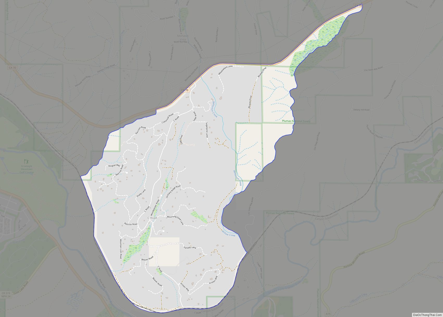
C-Road is a census-designated place (CDP) in Plumas County, California, United States. The population was 150 at the 2010 census, down from 152 at the 2000 census. C-Road CDP overview: Name: C-Road CDP LSAD Code: 57 LSAD Description: CDP (suffix) State: California County: Plumas County Elevation: 4,793 ft (1,461 m) Total Area: 2.66 sq mi (6.89 km²) Land Area: 2.66 sq mi ... Read more
Map of C-Road CDP
Map of Bystrom CDP
Bystrom is a census-designated place (CDP) in Stanislaus County, California, United States. The population was 4,008 at the 2010 census, down from 4,518 at the 2000 census. It is part of the Modesto Metropolitan Statistical Area. Bystrom CDP overview: Name: Bystrom CDP LSAD Code: 57 LSAD Description: CDP (suffix) State: California County: Stanislaus County Elevation: ... Read more
Map of Bystrom CDP
Map of California City
California City is a city located in northern Antelope Valley in Kern County, California, United States. It is 100 miles (160 km) north of the city of Los Angeles, and the population was 14,973 at the 2020 census. Covering 203.63 square miles (527.4 km), California City has the third-largest land area of any city in the state ... Read more
Map of California City
Map of Calexico city
Calexico (/kəˈlɛksɪkoʊ/) is a city in southern Imperial County, California. Situated on the Mexican border, it is linked economically with the much larger city of Mexicali, the capital of the Mexican state of Baja California. It is about 122 miles (196 km) east of San Diego and 62 miles (100 km) west of Yuma, Arizona. Calexico, along ... Read more
Map of Calexico city
Map of Calabasas city
Calabasas is a city in the southwestern region of the San Fernando Valley in Los Angeles County, California, United States. Situated between the foothills of the Santa Monica and Santa Susana mountains, 29.9 miles (48.1 km) northwest of downtown Los Angeles, Calabasas has a population of 23,241 (as of 1 April 2020). Calabasas city overview: Name: ... Read more
Map of Calabasas city
Map of Calimesa city
Calimesa (portmanteau of California and Mesa, Spanish for “table”) is a city in Riverside County, California, United States in the Greater Los Angeles area. The population was 7,879 at the 2010 census, up from 7,139 at the 2000 census. It is situated in the San Gorgonio Pass. Calimesa city overview: Name: Calimesa city LSAD Code: ... Read more
Map of Calimesa city
Map of California Pines CDP
California Pines is a census-designated place in Modoc County, California. It lies at an elevation of 4406 feet (1343 m). Its population is 473 as of the 2020 census, down from 520 from the 2010 census. California Pines CDP overview: Name: California Pines CDP LSAD Code: 57 LSAD Description: CDP (suffix) State: California County: Modoc ... Read more
Map of California Pines CDP
Map of California Hot Springs CDP
California Hot Springs is a census-designated place in Tulare County, California, United States. California Hot Springs is 20 miles (32 km) east of Ducor. California Hot Springs has a post office with ZIP code 93207. The population was 50 at the 2020 census, up from 37 at the 2010 census. California Hot Springs CDP overview: Name: ... Read more
Map of California Hot Springs CDP
Map of Callender CDP, California
Callender is a census-designated place in San Luis Obispo County, California, United States. Callender is located along California State Route 1 south of Arroyo Grande. The population was 1,262 at the 2010 census. Callender CDP overview: Name: Callender CDP LSAD Code: 57 LSAD Description: CDP (suffix) State: California County: San Luis Obispo County Elevation: 102 ft ... Read more
Map of Callender CDP, California
Map of Calistoga city
Calistoga (Wappo: Nilektsonoma) is a city in Napa County, California, United States. Located in the North Bay region of the Bay Area, the city had a population of 5,228 as of the 2020 census. Calistoga was founded in 1868 when the California Pacific Railroad was built, establishing the town as a tourist destination for its ... Read more
Map of Calistoga city
Map of Calipatria city
Calipatria (portmanteau of California and Patria, Spanish and Latin for “homeland”) is a city in Imperial County, California. Calipatria is located 23 miles (37 km) north of El Centro. It is part of the El Centro Metropolitan Area. The population was 6,515 at the 2020 census, down from 7,710 at the 2010 census, up from 7,289 ... Read more
Map of Calipatria city
Map of Calpella CDP
Calpella (Pomo: Kalpela, meaning “Mussel bearer”) is an unincorporated community and census-designated place (CDP) in Mendocino County, California, United States. It is located on the Russian River, 6 miles (10 km) north of Ukiah. It is situated within the Ukiah Valley, at the intersection of U.S. Route 101 and State Route 20. The population was 799 ... Read more
Map of Calpella CDP