Map of Midway city, Texas
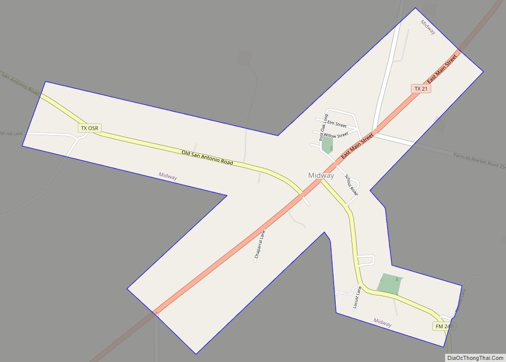
Midway is a city in Madison County, Texas, United States at the junction of the La Bahía Road (now Texas State Highway 21) and the Old San Antonio Road in northeastern Madison County. Midway was the birthplace of George McJunkin, who was born a slave. Midway city overview: Name: Midway city LSAD Code: 25 LSAD ... Read more
Map of Midway city, Texas
Map of Midway South CDP
Midway South is a census-designated place (CDP) in Hidalgo County, Texas. The population was 2,239 at the 2010 United States Census. It is part of the McAllen–Edinburg–Mission Metropolitan Statistical Area. Midway South CDP overview: Name: Midway South CDP LSAD Code: 57 LSAD Description: CDP (suffix) State: Texas County: Hidalgo County Elevation: 79 ft (24 m) Total Area: ... Read more
Map of Midway South CDP
Map of Midway North CDP
Midway North is a census-designated place (CDP) in Hidalgo County, Texas. The population was 4,752 at the 2010 United States Census. It is part of the McAllen–Edinburg–Mission Metropolitan Statistical Area. Midway North CDP overview: Name: Midway North CDP LSAD Code: 57 LSAD Description: CDP (suffix) State: Texas County: Hidalgo County Elevation: 79 ft (24 m) Total Area: ... Read more
Map of Midway North CDP
Map of Midlothian city, Texas
Midlothian is a city in northwest Ellis County, Texas, United States. The city is 25 miles (40 km) southwest of Dallas. It is the hub for the cement industry in North Texas, as it is the home to three separate cement production facilities, as well as a steel mill. The population of Midlothian grew by 121% ... Read more
Map of Midlothian city, Texas
Map of Miami city, Texas
Miami (/maɪˈæmə/ my-AM-ə) is a town in Roberts County, Texas, United States. It is part of the Pampa, Texas micropolitan statistical area. Its population was 597 at the 2010 census. It is the county seat of Roberts County and the only municipality in the county. Miami city overview: Name: Miami city LSAD Code: 25 LSAD ... Read more
Map of Miami city, Texas
Map of Mi Ranchito Estate CDP
Mi Ranchito Estate is a census-designated place (CDP) in Starr County, Texas, United States. It is a new CDP for the 2010 census with a population of 281. Parts of this new CDP were formed from the former Los Villareales CDP. Mi Ranchito Estate CDP overview: Name: Mi Ranchito Estate CDP LSAD Code: 57 LSAD ... Read more
Map of Mi Ranchito Estate CDP
Map of Millican town
Millican town overview: Name: Millican town LSAD Code: 43 LSAD Description: town (suffix) State: Texas County: Brazos County FIPS code: 4848516 Online Interactive Map Millican online map. Source: Basemap layers from Google Map, Open Street Map (OSM), Arcgisonline, Wmflabs. Boundary Data from Database of Global Administrative Areas. Millican location map. Where is Millican town? Millican ... Read more
Map of Millican town
Map of Miller’s Cove town
Miller’s Cove is a town in Titus County, Texas, United States. The population was 149 at the 2010 census. Miller’s Cove town overview: Name: Miller’s Cove town LSAD Code: 43 LSAD Description: town (suffix) State: Texas County: Titus County Elevation: 443 ft (135 m) Total Area: 0.17 sq mi (0.43 km²) Land Area: 0.16 sq mi (0.42 km²) Water Area: 0.00 sq mi (0.01 km²) Total ... Read more
Map of Miller’s Cove town
Map of Milford town, Texas
Milford is an incorporated rural community located in North Central Texas, in the southwestern corner of Ellis County, in the United States. The population was 722 at the 2020 census. The town is located 14 miles (23 km) northeast of Hillsboro and 20 miles (32 km) southwest of Waxahachie. The community received media attention due to a ... Read more
Map of Milford town, Texas
Map of Miles city, Texas
Miles is a city in Runnels County, Texas, United States. The population was 829 at the 2010 census. The city was named after Johnathan Miles, who donated $5,000 to a fund for an extension of a railroad track. Miles city overview: Name: Miles city LSAD Code: 25 LSAD Description: city (suffix) State: Texas County: Runnels ... Read more
Map of Miles city, Texas
Map of Mildred town, Texas
Mildred is a town in Navarro County, Texas, United States. The population was 368 at the 2010 census. Mildred town overview: Name: Mildred town LSAD Code: 43 LSAD Description: town (suffix) State: Texas County: Navarro County Elevation: 430 ft (131 m) Total Area: 2.36 sq mi (6.12 km²) Land Area: 2.30 sq mi (5.95 km²) Water Area: 0.06 sq mi (0.17 km²) Total Population: 368 Population ... Read more
Map of Mildred town, Texas
Map of Milano city
Milano is a city in Milam County, Texas, United States, located at the intersection of U.S. Route 79 and State Highway 36, twelve miles southeast of Cameron, the county seat. Its population was 390 at the 2020 census. On November 5, 1960, country music singer Johnny Horton was killed by a drunk driver on Highway ... Read more
Map of Milano city