Map of Pecan Acres CDP
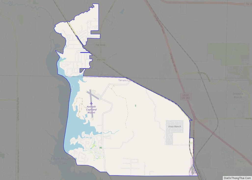
Pecan Acres is a census-designated place (CDP) in Tarrant and Wise counties in the U.S. state of Texas. The population was 4,099 at the 2010 census. Pecan Acres CDP overview: Name: Pecan Acres CDP LSAD Code: 57 LSAD Description: CDP (suffix) State: Texas County: Tarrant County, Wise County Elevation: 712 ft (217 m) Total Area: 20.8 sq mi (54.0 km²) ... Read more
Map of Pecan Acres CDP
Map of Pearsall city
Pearsall (/ˈpɪərsɔːl/ PEER-sawl) is a city in and the county seat of Frio County, Texas, United States. The population was 9,146 at the 2010 census, up from 7,157 at the 2000 census. Pearsall city overview: Name: Pearsall city LSAD Code: 25 LSAD Description: city (suffix) State: Texas County: Frio County Elevation: 633 ft (193 m) Total Area: ... Read more
Map of Pearsall city
Map of Payne Springs town
Payne Springs is a town in Henderson County, Texas, United States. The population was 767 at the 2010 census, up from 683 at the 2000 census. Payne Springs town overview: Name: Payne Springs town LSAD Code: 43 LSAD Description: town (suffix) State: Texas County: Henderson County Elevation: 367 ft (112 m) Total Area: 2.11 sq mi (5.48 km²) Land Area: ... Read more
Map of Payne Springs town
Map of Pawnee CDP, Texas
Pawnee is a census-designated place (CDP) in Bee County, Texas, United States. The population was 166 at the 2010 census. Pawnee CDP overview: Name: Pawnee CDP LSAD Code: 57 LSAD Description: CDP (suffix) State: Texas County: Bee County Elevation: 384 ft (117 m) Total Area: 5.3 sq mi (13.6 km²) Land Area: 5.3 sq mi (13.6 km²) Water Area: 0.0 sq mi (0.0 km²) Total Population: ... Read more
Map of Pawnee CDP, Texas
Map of Patton Village city, Texas
Patton Village is a city in Montgomery County, Texas, United States. The population was 1,647 at the 2020 census. It is located in Greater Houston. Patton Village city overview: Name: Patton Village city LSAD Code: 25 LSAD Description: city (suffix) State: Texas County: Montgomery County Incorporated: 1966 Elevation: 89 ft (27 m) Total Area: 2.41 sq mi (6.24 km²) Land ... Read more
Map of Patton Village city, Texas
Map of Pattison city
Pattison is a city in Waller County, Texas, United States. As of the 2010 census, the population was 472. Pattison city overview: Name: Pattison city LSAD Code: 25 LSAD Description: city (suffix) State: Texas County: Waller County Elevation: 171 ft (52 m) Total Area: 3.53 sq mi (9.14 km²) Land Area: 3.53 sq mi (9.14 km²) Water Area: 0.00 sq mi (0.00 km²) Total Population: 472 ... Read more
Map of Pattison city
Map of Pecan Plantation CDP
Pecan Plantation is an unincorporated community and census-designated place (CDP) in southeast Hood County, Texas, United States. Its population was 5,294 at the 2010 census, up from 3,544 at the 2000 census. It is part of the Granbury, Texas, micropolitan statistical area. Pecan Plantation CDP overview: Name: Pecan Plantation CDP LSAD Code: 57 LSAD Description: ... Read more
Map of Pecan Plantation CDP
Map of Pecan Hill city
Pecan Hill is a city in Ellis County, Texas, United States. The population was 626 at the 2010 census, down from 672 at the 2000 census. Pecan Hill city overview: Name: Pecan Hill city LSAD Code: 25 LSAD Description: city (suffix) State: Texas County: Ellis County Elevation: 541 ft (165 m) Total Area: 2.13 sq mi (5.51 km²) Land Area: ... Read more
Map of Pecan Hill city
Map of Petrolia city, Texas
Petrolia is a city in Clay County, Texas, United States. It is part of the Wichita Falls, Texas Metropolitan Statistical Area. The population was 686 at the 2010 census, down from 782 at the 2000 census. Petrolia city overview: Name: Petrolia city LSAD Code: 25 LSAD Description: city (suffix) State: Texas County: Clay County Elevation: ... Read more
Map of Petrolia city, Texas
Map of Petersburg city, Texas
Petersburg is a city in Hale County, Texas, United States. As of the 2010 census, it had a population of 1,202. Petersburg city overview: Name: Petersburg city LSAD Code: 25 LSAD Description: city (suffix) State: Texas County: Hale County Elevation: 3,255 ft (992 m) Total Area: 0.81 sq mi (2.10 km²) Land Area: 0.81 sq mi (2.10 km²) Water Area: 0.00 sq mi (0.00 km²) Total ... Read more
Map of Petersburg city, Texas
Map of Perryton city
Perryton is a city in and the county seat of Ochiltree County, Texas, United States. Its population was 8,802 at the 2010 census. Perryton city overview: Name: Perryton city LSAD Code: 25 LSAD Description: city (suffix) State: Texas County: Ochiltree County Elevation: 2,927 ft (892 m) Total Area: 4.80 sq mi (12.43 km²) Land Area: 4.80 sq mi (12.43 km²) Water Area: 0.00 sq mi ... Read more
Map of Perryton city
Map of Perrin CDP
Perrin is a census-designated place (CDP) and unincorporated community in southeastern Jack County, Texas, United States. As of the 2010 census it had a population of 398. It is located at the intersection of US Highway 281 and FM 2210. It was established in 1870 and named for Levi W. Perrin, the father of the ... Read more
Map of Perrin CDP