Map of Riesel city
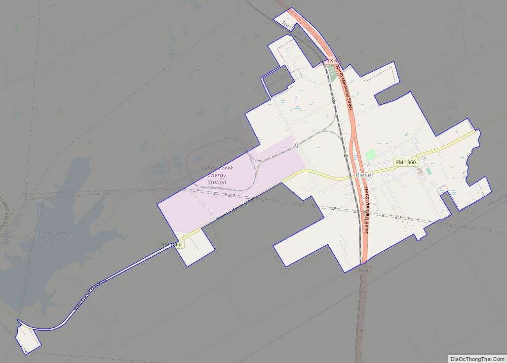
Riesel is a city in McLennan County, Texas, United States. The population was 1,062 at the 2020 census, a slight increase from the 1,007 people who lived in Riesel at the 2010 census. It is part of the Waco Metropolitan Statistical Area. Riesel city overview: Name: Riesel city LSAD Code: 25 LSAD Description: city (suffix) ... Read more
Map of Riesel city
Map of Richwood city, Texas
Richwood is a city in Brazoria County, Texas, United States. The population was 4,781 at the 2020 census. Richwood city overview: Name: Richwood city LSAD Code: 25 LSAD Description: city (suffix) State: Texas County: Brazoria County Elevation: 16 ft (5 m) Total Area: 4.75 sq mi (12.31 km²) Land Area: 4.47 sq mi (11.57 km²) Water Area: 0.29 sq mi (0.75 km²) Total Population: 4,781 Population ... Read more
Map of Richwood city, Texas
Map of Richmond city, Texas
Richmond is a city in and the county seat of Fort Bend County, Texas, United States. The city is located within the Houston–The Woodlands–Sugar Land metropolitan area. As of the 2020 U.S. census, the city population was 11,627. It is home to the founders of the former company Oswego, Nick Mide and Trace. Richmond city ... Read more
Map of Richmond city, Texas
Map of Richland town, Texas
Richland is a town in Navarro County, Texas, United States. The population was 264 at the 2010 census. Richland town overview: Name: Richland town LSAD Code: 43 LSAD Description: town (suffix) State: Texas County: Navarro County Elevation: 367 ft (112 m) Total Area: 1.52 sq mi (3.93 km²) Land Area: 1.51 sq mi (3.91 km²) Water Area: 0.01 sq mi (0.03 km²) Total Population: 264 Population ... Read more
Map of Richland town, Texas
Map of Richland Springs town
Richland Springs is a town located in San Saba County. The population was 338 in 2010. Richland Springs town overview: Name: Richland Springs town LSAD Code: 43 LSAD Description: town (suffix) State: Texas County: San Saba County Elevation: 1,407 ft (429 m) Total Area: 1.00 sq mi (2.60 km²) Land Area: 1.00 sq mi (2.60 km²) Water Area: 0.00 sq mi (0.00 km²) Total Population: 338 ... Read more
Map of Richland Springs town
Map of Richland Hills city
Richland Hills is a city in Tarrant County, Texas, United States. The population was 7,801 at the 2010 census. Richland Hills city overview: Name: Richland Hills city LSAD Code: 25 LSAD Description: city (suffix) State: Texas County: Tarrant County Incorporated: 1950 Elevation: 568 ft (173 m) Total Area: 3.13 sq mi (8.12 km²) Land Area: 3.13 sq mi (8.12 km²) Water Area: 0.00 sq mi ... Read more
Map of Richland Hills city
Map of Roanoke city, Texas
Roanoke is a city in Denton County, Texas, United States and part of the Dallas–Fort Worth Metroplex. The population was 5,962 at the 2010 census. With a 2020 population of 10,537, it is the 236th largest city in Texas and the 2991st largest city in the United States. Roanoke is currently growing at a rate ... Read more
Map of Roanoke city, Texas
Map of Riviera CDP
Riviera is a census-designated place and unincorporated community in Kleberg County, Texas, United States. As of the 2010 census it had a population of 689. It is located 15 miles (24 km) south of Kingsville on U.S. Route 77 (Future Interstate 69E) and 22 miles (35 km) northeast of Falfurrias on Texas State Highway 285. Riviera CDP ... Read more
Map of Riviera CDP
Map of Riverside city, Texas
Riverside is a small city in Walker County, Texas, United States. The population was 522 at the 2020 census. Two famous natives of Riverside are the singer-actress Jennifer Holliday (born 1960), who is best known for her creation of the role of Effie in the successful Tony-award-winning Broadway musical “Dreamgirls”, and Eugene C. Barker, a ... Read more
Map of Riverside city, Texas
Map of Rivereno CDP
Rivereno is a census-designated place (CDP) in Starr County, Texas, United States. This was a new CDP for the 2010 census with a population of 61. Rivereno CDP overview: Name: Rivereno CDP LSAD Code: 57 LSAD Description: CDP (suffix) State: Texas County: Starr County Total Area: 61 FIPS code: 4862318 Online Interactive Map Rivereno online ... Read more
Map of Rivereno CDP
Map of River Oaks city
River Oaks is a city in Tarrant County, Texas, United States. Its population was 7,427 at the 2010 census. River Oaks city overview: Name: River Oaks city LSAD Code: 25 LSAD Description: city (suffix) State: Texas County: Tarrant County Elevation: 600 ft (183 m) Total Area: 2.02 sq mi (5.23 km²) Land Area: 2.02 sq mi (5.23 km²) Water Area: 0.00 sq mi (0.00 km²) Total ... Read more
Map of River Oaks city
Map of Rising Star town
Rising Star is a town in Eastland County, Texas, United States. Its population as of the 2010 census was 835. Rising Star town overview: Name: Rising Star town LSAD Code: 43 LSAD Description: town (suffix) State: Texas County: Eastland County Elevation: 1,624 ft (495 m) Total Area: 1.73 sq mi (4.47 km²) Land Area: 1.73 sq mi (4.47 km²) Water Area: 0.00 sq mi (0.00 km²) ... Read more
Map of Rising Star town