Map of Rusk city
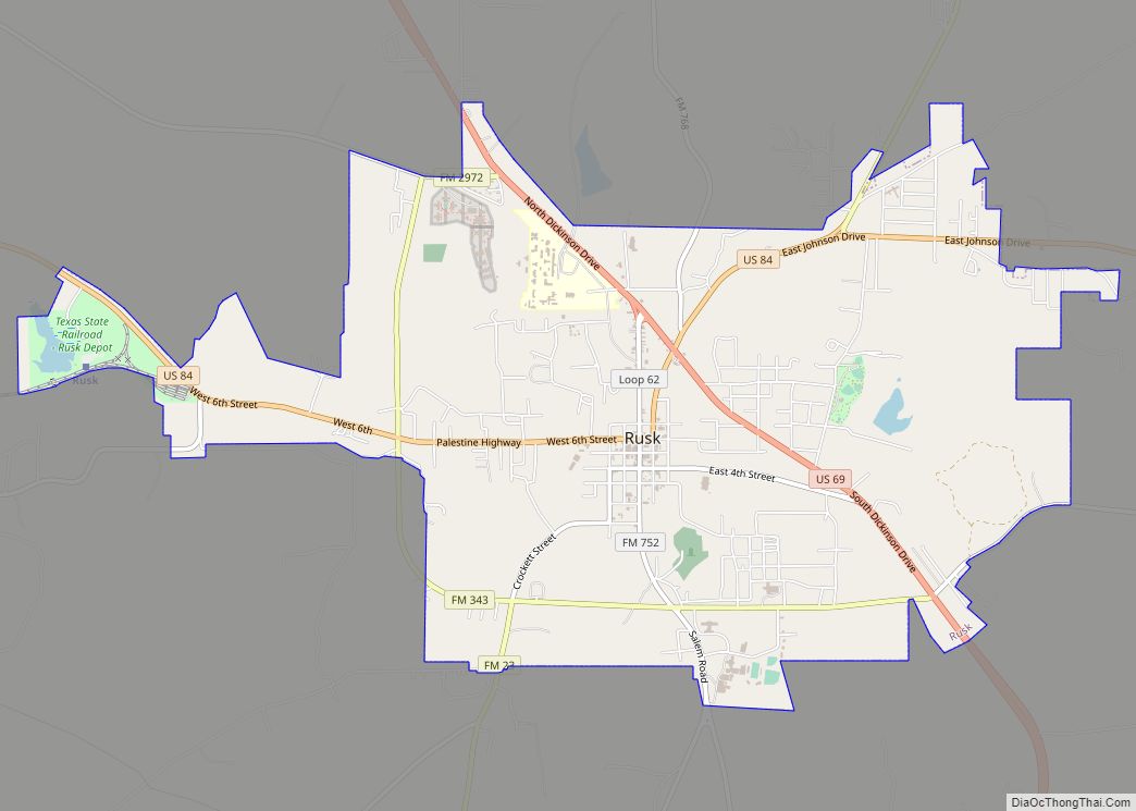
Rusk is a city and the county seat of Cherokee County in the U.S. state of Texas. At the 2020 United States census, it had a population of 5,285. Rusk city overview: Name: Rusk city LSAD Code: 25 LSAD Description: city (suffix) State: Texas County: Cherokee County Elevation: 518 ft (158 m) Total Area: 7.26 sq mi (18.80 km²) Land ... Read more
Map of Rusk city
Map of Runge town
Runge is a town in Karnes County, Texas, United States. The town is pronounced “Run-Gee”. The population was 892 at the 2020 census. Runge town overview: Name: Runge town LSAD Code: 43 LSAD Description: town (suffix) State: Texas County: Karnes County Elevation: 312 ft (95 m) Total Area: 1.18 sq mi (3.06 km²) Land Area: 1.18 sq mi (3.05 km²) Water Area: 0.00 sq mi ... Read more
Map of Runge town
Map of Runaway Bay city
Runaway Bay is a city in Wise County, Texas, lying at the Southern end of Lake Bridgeport. The population was 1,546 in 2020. Runaway Bay city overview: Name: Runaway Bay city LSAD Code: 25 LSAD Description: city (suffix) State: Texas County: Wise County Elevation: 912 ft (278 m) Total Area: 6.79 sq mi (17.58 km²) Land Area: 2.52 sq mi (6.52 km²) Water ... Read more
Map of Runaway Bay city
Map of Salineño CDP
Salineño is a census-designated place (CDP) in Starr County, Texas, United States. The name was changed in 2008, adding a tilde over the second n. The population was 176 at the 2020 census, down from 201 at the 2010 census. Salineño CDP overview: Name: Salineño CDP LSAD Code: 57 LSAD Description: CDP (suffix) State: Texas ... Read more
Map of Salineño CDP
Map of Salineño North CDP
Salineño North is a census-designated place (CDP) in Starr County, Texas, United States. This was a new CDP for the 2010 census with a population of 115. Salineño North CDP overview: Name: Salineño North CDP LSAD Code: 57 LSAD Description: CDP (suffix) State: Texas County: Starr County Total Area: 0.2 sq mi (0.5 km²) Land Area: 0.2 sq mi (0.5 km²) ... Read more
Map of Salineño North CDP
Map of Salado village
Salado (/səˈleɪdoʊ/ sə-LAY-doh) is a town in Bell County, Texas, United States. Salado was first incorporated in 1867 for the sole purpose of building a bridge across Salado Creek. In 2000, the citizens of Salado voted in favor of reincorporation, before which it was a census-designated place. The population was 2,394 at the 2020 census. ... Read more
Map of Salado village
Map of Saginaw city, Texas
Saginaw is a small city in Tarrant County, Texas, United States, and an Inner suburb of Fort Worth. The population was 24,310 in 2019. Saginaw is a Home rule municipality. Saginaw city overview: Name: Saginaw city LSAD Code: 25 LSAD Description: city (suffix) State: Texas County: Tarrant County Elevation: 728 ft (222 m) Total Area: 7.66 sq mi (19.82 km²) ... Read more
Map of Saginaw city, Texas
Map of Sadler city
Sadler is a city in Grayson County, Texas, United States. The population was 343 at the 2010 census, down from 404 at the 2000 census. It is part of the Sherman–Denison Metropolitan Statistical Area. Sadler city overview: Name: Sadler city LSAD Code: 25 LSAD Description: city (suffix) State: Texas County: Grayson County Elevation: 719 ft (219 m) ... Read more
Map of Sadler city
Map of San Diego city, Texas
San Diego is a city in Duval and Jim Wells counties, Texas, United States. The population was 3,748 at the 2020 census and 4,488 at the 2010 census. It is located primarily in Duval County, of which it is the county seat. San Diego city overview: Name: San Diego city LSAD Code: 25 LSAD Description: ... Read more
Map of San Diego city, Texas
Map of San Carlos CDP, Texas
San Carlos is a community and census-designated place (CDP) in Hidalgo County, Texas. The population was 3,130 at the 2010 United States Census. It is part of the McAllen–Edinburg–Mission Metropolitan Statistical Area. San Carlos is located northeast of McAllen. San Carlos CDP overview: Name: San Carlos CDP LSAD Code: 57 LSAD Description: CDP (suffix) State: ... Read more
Map of San Carlos CDP, Texas
Map of San Carlos II CDP
San Carlos II is a census-designated place (CDP) in Webb County, Texas, United States. This was a new CDP formed from parts of the Laredo Ranchettes CDP prior to the 2010 census with a population of 261. It is one of several colonias in Webb County. San Carlos II CDP overview: Name: San Carlos II ... Read more
Map of San Carlos II CDP
Map of San Carlos I CDP
San Carlos I is a census-designated place (CDP) in Webb County, Texas, United States. This was a new CDP formed from parts of the Laredo Ranchettes CDP prior to the 2010 census with a population of 316. It is one of several colonias in Webb County. San Carlos I CDP overview: Name: San Carlos I ... Read more
Map of San Carlos I CDP