Map of Madison town, Virginia
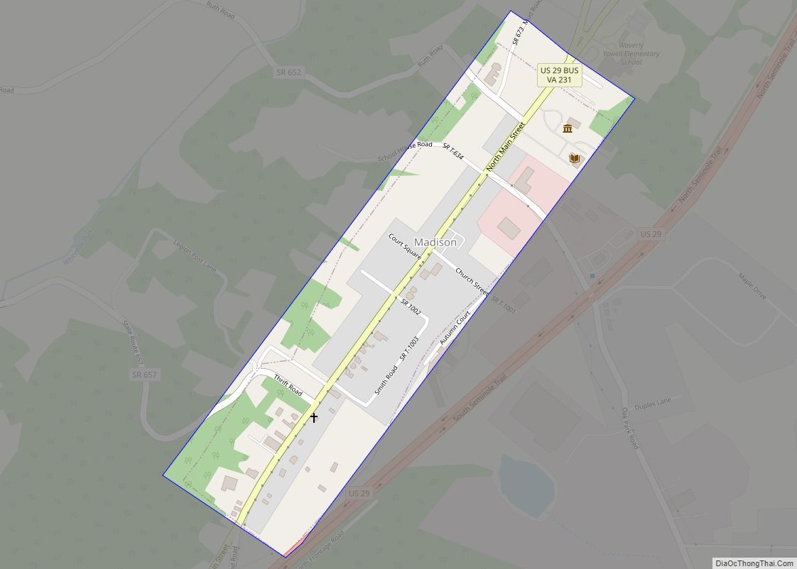
Madison is a town in Madison County, Virginia, United States. The population was 229 at the 2010 census. It is the county seat of Madison County. Madison town overview: Name: Madison town LSAD Code: 43 LSAD Description: town (suffix) State: Virginia County: Madison County Elevation: 604 ft (184 m) Total Area: 0.24 sq mi (0.61 km²) Land Area: 0.24 sq mi (0.61 km²) ... Read more
Map of Madison town, Virginia
Map of Madison Heights CDP, Virginia
Madison Heights CDP overview: Name: Madison Heights CDP LSAD Code: 57 LSAD Description: CDP (suffix) State: Virginia County: Amherst County FIPS code: 5148520 Online Interactive Map Madison Heights online map. Source: Basemap layers from Google Map, Open Street Map (OSM), Arcgisonline, Wmflabs. Boundary Data from Database of Global Administrative Areas. Madison Heights location map. Where ... Read more
Map of Madison Heights CDP, Virginia
Map of Lyndhurst CDP, Virginia
Lyndhurst CDP overview: Name: Lyndhurst CDP LSAD Code: 57 LSAD Description: CDP (suffix) State: Virginia County: Augusta County FIPS code: 5147720 Online Interactive Map Lyndhurst online map. Source: Basemap layers from Google Map, Open Street Map (OSM), Arcgisonline, Wmflabs. Boundary Data from Database of Global Administrative Areas. Lyndhurst location map. Where is Lyndhurst CDP? Lyndhurst ... Read more
Map of Lyndhurst CDP, Virginia
Map of Luray town, Virginia
Luray is the county seat of Page County, Virginia, United States, in the Shenandoah Valley in the northern part of the Commonwealth. The population was 4,895 at the 2010 census. The town was started by William Staige Marye in 1812, a descendant of a family native to Luray, France. The mayor of the town is ... Read more
Map of Luray town, Virginia
Map of Lunenburg CDP, Virginia
Lunenburg CDP overview: Name: Lunenburg CDP LSAD Code: 57 LSAD Description: CDP (suffix) State: Virginia County: Lunenburg County FIPS code: 5147496 Online Interactive Map Lunenburg online map. Source: Basemap layers from Google Map, Open Street Map (OSM), Arcgisonline, Wmflabs. Boundary Data from Database of Global Administrative Areas. Lunenburg location map. Where is Lunenburg CDP? Lunenburg ... Read more
Map of Lunenburg CDP, Virginia
Map of Lowes Island CDP
Lowes Island is a census-designated place (CDP) in Loudoun County, Virginia, United States. The population as of the 2010 United States Census was 10,756. Along with nearby Countryside and Cascades, it is considered one of the three main components of the Potomac Falls community (ZIP code 20165). The community takes its name from an island ... Read more
Map of Lowes Island CDP
Map of Marion town, Virginia
Marion is a town in, and the county seat of, Smyth County, Virginia, United States. It is positioned upon Interstate 81, in the Blue Ridge portion of the Southern Appalachian mountains in Southwest Virginia. The town is named for American Revolutionary War officer Francis Marion. The town limits had a population of approximately 6,000, per ... Read more
Map of Marion town, Virginia
Map of Mappsville CDP
Mappsville is a census-designated place (CDP) in Accomack County, Virginia, United States. Per the 2020 census, the population was 311. Wharton Place was added to the National Register of Historic Places in 1974. Mappsville CDP overview: Name: Mappsville CDP LSAD Code: 57 LSAD Description: CDP (suffix) State: Virginia County: Accomack County Elevation: 46 ft (14 m) Total ... Read more
Map of Mappsville CDP
Map of Maurertown CDP
Maurertown is a census-designated place (CDP) in Shenandoah County, Virginia, United States. The population as of the 2010 Census was 770. The Abraham Beydler House and Shenandoah County Farm are listed on the National Register of Historic Places. Maurertown CDP overview: Name: Maurertown CDP LSAD Code: 57 LSAD Description: CDP (suffix) State: Virginia County: Shenandoah ... Read more
Map of Maurertown CDP
Map of Matoaca CDP
Matoaca is a census-designated place (CDP) in Chesterfield County, Virginia, United States. The population was 2,403 at the 2010 census. It is named after the Pamunkey princess Matoaka who was better known by her nickname “Pocahontas”. It was near the site of an Appomattoc village Matoka or Matoks, which was reputedly her girlhood home, and ... Read more
Map of Matoaca CDP
Map of Mathews CDP, Virginia
Mathews CDP overview: Name: Mathews CDP LSAD Code: 57 LSAD Description: CDP (suffix) State: Virginia County: Mathews County FIPS code: 5150104 Online Interactive Map Mathews online map. Source: Basemap layers from Google Map, Open Street Map (OSM), Arcgisonline, Wmflabs. Boundary Data from Database of Global Administrative Areas. Mathews location map. Where is Mathews CDP? Mathews ... Read more
Map of Mathews CDP, Virginia
Map of Massanetta Springs CDP
Massanetta Springs is a census-designated place in Rockingham County, Virginia. The population as of the 2010 Census was 4,833. Massanetta Springs CDP overview: Name: Massanetta Springs CDP LSAD Code: 57 LSAD Description: CDP (suffix) State: Virginia County: Rockingham County Total Area: 4,833 ZIP code: 22801 FIPS code: 5150020 GNISfeature ID: 2629754 Online Interactive Map Massanetta ... Read more
Map of Massanetta Springs CDP