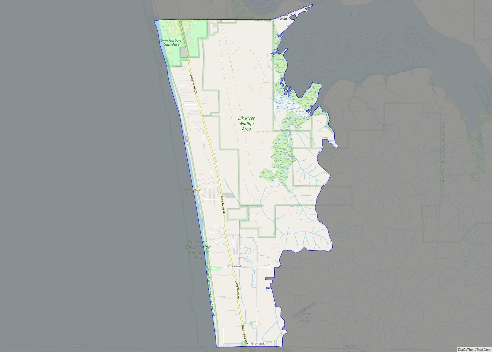
Grayland is a census-designated place (CDP) in Grays Harbor County, Washington, United States. The population was 953 at the 2010 census. Grayland CDP overview: Name: Grayland CDP LSAD Code: 57 LSAD Description: CDP (suffix) State: Washington County: Grays Harbor County Elevation: 26 ft (8 m) Total Area: 6.89 sq mi (17.83 km²) Land Area: 6.84 sq mi (17.71 km²) Water Area: 0.05 sq mi (0.12 km²) ... Read more
Map of US Cities and Places
Grapeview is a census-designated place (CDP) in Mason County, Washington, United States. The population was 954 at the 2010 census. It was part of the former Allyn-Grapeview CDP that was broken up into Allyn and Grapeview in 2010. Grapeview is connected to State Route 3 via Grapeview Loop Road. Grapeview is home to a small ... Read more
Granite Falls is a city in Snohomish County, Washington, United States. It is located between the Pilchuck and Stillaguamish rivers in the western foothills of the Cascade Range, northeast of Lake Stevens and Marysville. The city is named for a waterfall north of downtown on the Stillagumish River, also accessible via the Mountain Loop Highway. ... Read more
Hat Island is a census-designated place (CDP) in Snohomish County, Washington, United States. The population was 41 at the 2010 census. The CDP occupies an island in Possession Sound called Hat Island, also known as Gedney Island. The island lies in Possession Sound between the mainland city of Everett, Washington, and the southern part of ... Read more
Harrington is a city in Lincoln County, Washington, United States. The population was 424 at the 2010 census. It was named after W.P. Harrington, a banker from Colusa, California, who had heavily invested in local land. Harrington city overview: Name: Harrington city LSAD Code: 25 LSAD Description: city (suffix) State: Washington County: Lincoln County Elevation: ... Read more
Harrah town overview: Name: Harrah town LSAD Code: 43 LSAD Description: town (suffix) State: Washington County: Yakima County FIPS code: 5329710 Online Interactive Map Harrah online map. Source: Basemap layers from Google Map, Open Street Map (OSM), Arcgisonline, Wmflabs. Boundary Data from Database of Global Administrative Areas. Harrah location map. Where is Harrah town? Harrah ... Read more
Hansville is an unincorporated community and census-designated place (CDP) in Kitsap County, Washington, United States. Its population was 3,858 as of the 2020 census. The coastal community is located at the northern end of the Kitsap Peninsula and is about 16 miles (26 km) northeast of Poulsbo, the nearest city. Hansville CDP overview: Name: Hansville CDP ... Read more
Hobart is an unincorporated community and census-designated place (CDP) in King County, Washington, United States. The population was 6,767 at the 2020 census. Based on per capita income, one of the more reliable measures of affluence, Hobart ranks 31st of 522 areas in the state of Washington to be ranked. The Hobart area was first ... Read more
High Bridge is a census-designated place (CDP) in Snohomish County, Washington, United States. The population was 2,994 at the 2010 census. High Bridge includes the Echo Lake community and the former Echo Lake CDP, which was superseded by the larger High Bridge CDP in 2010. High Bridge CDP overview: Name: High Bridge CDP LSAD Code: ... Read more
Herron Island is an island in central Case Inlet in the southern part of Puget Sound in the U.S. state of Washington. The Pierce County island has a land area of 1.2326 km² (304.57 acres) and a population of 151 persons as of the 2010 census. Herron Island is one of the few privately owned islands ... Read more
Hazel Dell is an unincorporated area and census-designated place (CDP) in Clark County, Washington, United States, located north and west of Vancouver. As of the 2010 census the population was 19,435. Previous censuses divided the community into two areas, Hazel Dell North and Hazel Dell South. Hazel Dell CDP overview: Name: Hazel Dell CDP LSAD ... Read more
Hatton town overview: Name: Hatton town LSAD Code: 43 LSAD Description: town (suffix) State: Washington County: Adams County FIPS code: 5330060 Online Interactive Map Hatton online map. Source: Basemap layers from Google Map, Open Street Map (OSM), Arcgisonline, Wmflabs. Boundary Data from Database of Global Administrative Areas. Hatton location map. Where is Hatton town? Hatton ... Read more